International Mars Ice Mapper
NASA, CSA, JAXA and ASI, later joined by the Netherlands Space Office · Multinational · Orbiter · 2020 · Multipolar MarsCancelled
NASA terminated its financial support on 28 March 2022 and the other partners did not follow: Italy signed a 22 million euro Phase B1 contract on 8 March 2024. As of 24 August 2026 no agency has said whether it lives.
TL;DR· 14 min read
The International Mars Ice Mapper was a five-agency radar orbiter meant to map water ice in the top ten metres of Martian ground, at latitudes where a first human crew could land. Canada would build the radar, Japan the spacecraft, Italy the antenna, the Netherlands the solar arrays and the United States the launch, and no agency would lead. NASA's budget request of 28 March 2022 terminated its financial support. Italy carried on with a 22 million euro Phase B1 contract in March 2024, and nobody has said since whether the mission is alive.
The International Mars Ice Mapper was an unusual thing: a Mars mission with no lead agency. Canada would build the radar, Japan the spacecraft, Italy the antenna and communications, the Netherlands the solar arrays, and the United States would provide the launch and the management, with every decision taken by consensus. Its job was not science first but reconnaissance, mapping water ice in the top ten metres of Martian ground at latitudes where humans could plausibly land. Then NASA's budget for it was zeroed, and the partnership that had no leader discovered it also had no rocket.
- 5space agencies in the partnership: ASI, CSA, JAXA, NASA and the Netherlands Space Office
- 10 mdepth of Martian ground the radar was to map, at mid to low latitudes
- 28 Mar 2022date NASA's budget request terminated its financial support
Every plan for sending people to Mars runs into the same fact: you cannot carry the water. A crew needs it to drink, to breathe and, if the fuel is to be made on site rather than hauled from Earth, to turn into propellant, and the mass involved is far beyond anything a lander can bring. Mars has water, in enormous quantities, frozen into the ground, but the polar deposits are useless for a first crew because they are cold, dark and hard to land near, and the equatorial ground where landing is easy is the driest. So there is a band of mid to low latitudes where the two constraints might overlap, and nobody knew in any detail where within that band there is accessible ice under a few metres of loose material that a drill could reach. The International Mars Ice Mapper was the mission designed to answer exactly that, and it was scoped as reconnaissance rather than science: three objectives about where the ice is, whether you can get at it, and which particular patches of ground would also work for landing a heavy vehicle, launching one again, and building something. Science was in the charter too, as what the agencies called a supplemental value goal, but the driving requirements came from human exploration. That distinction turned out to matter more than anyone expected, because it determined which pot of money the mission lived in.
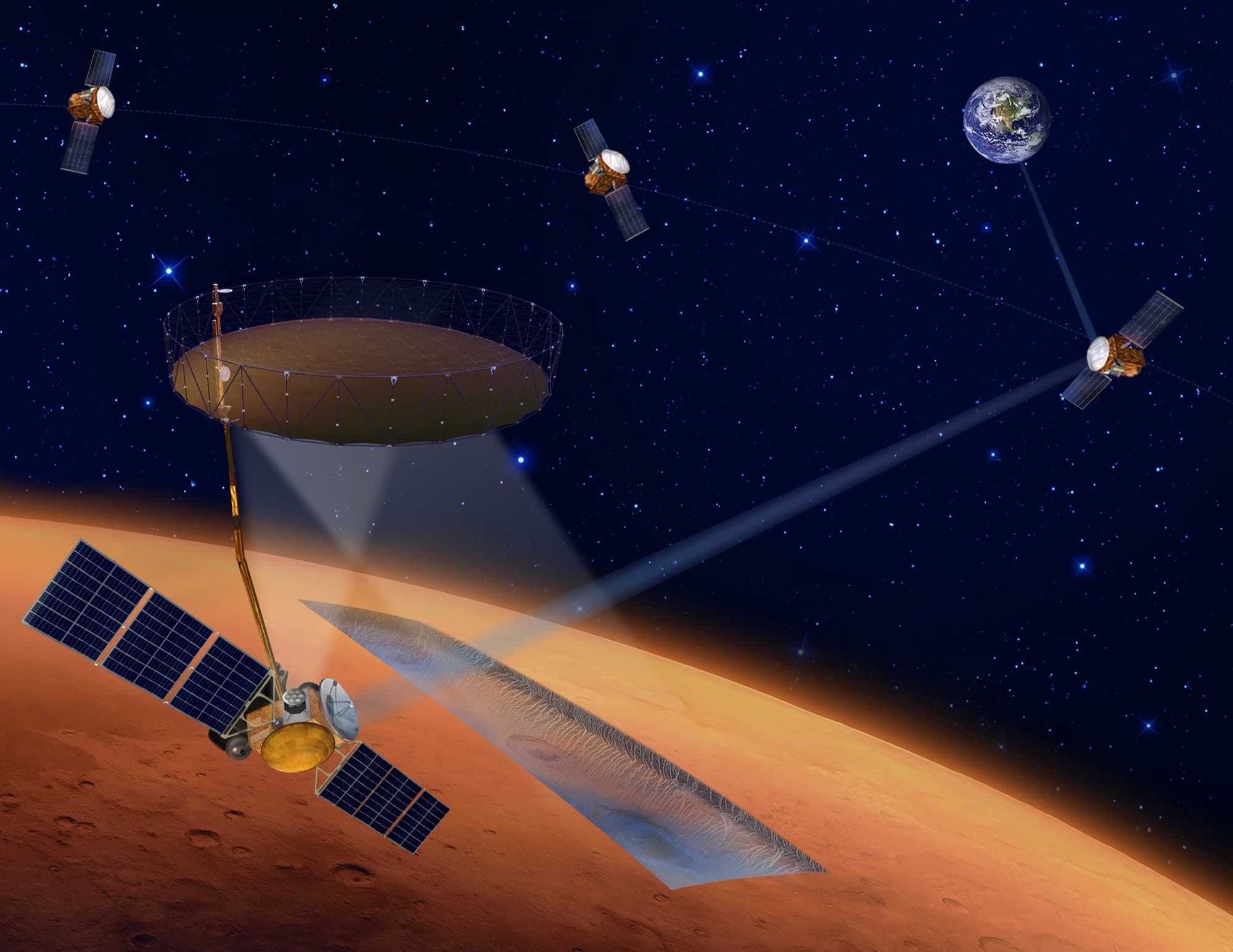
The partnership was the interesting part. Four agencies signed a statement of intent in January 2021, announced by NASA on 3 February, and a fifth joined later, and the division was almost perfectly complementary. Canada would build the anchor payload, an L-band polarimetric synthetic aperture radar at 930 MHz that could also work as a nadir sounder like MARSIS and SHARAD, drawing on Radarsat heritage and on radar work Canada had already funded for an earlier orbiter concept. Japan would build the spacecraft bus, arguing from its Earth-observation satellite experience. Italy would build the communications system and a six-metre deployable reflector that would serve both the high-rate Ka- and X-band links home and the radar itself. The Netherlands would build the solar arrays. The United States would provide the launch, the programme management and possibly a set of relay satellites, nicknamed COMbirds, parked at six to eight thousand kilometres to carry the very large data volume an L-band radar generates. And nobody would be in charge: the report states flatly that no single agency leads and that the concept team worked by consensus, with each partner's contribution traceable to its own national strategy document. The orbiter would sit at about 300 km and work for one Mars year.
It never got past the concept stage on the American side. Mars Sample Return was growing expensive, Europa Clipper had taken on 703 million dollars of cost growth, and NASA's planetary budget could not absorb both. The fiscal year 2023 budget request, released on 28 March 2022, put it in one sentence: due to the need to fund higher priorities, including to cover cost growth expected from Mars Sample Return, the budget terminates NASA financial support for the Mars Ice Mapper. As terminations go it was cheap. NASA had been projecting 40 million dollars a year in 2023 and 2024 and 30 million in 2025 and 2026, small sums precisely because NASA was contributing management and a launch rather than hardware, and Watzin had put the agency's total share at around 185 million dollars. There is an irony worth stating: a mission whose whole justification was preparing for human landings was killed to pay for a robotic sample return that was itself later restructured. The mission had also carried a quieter political problem from the start. Mars scientists had questioned prioritising ice mapping over other objectives, and Watzin's answer, that this was an exploration precursor with scientific benefits in the mould of Lunar Reconnaissance Orbiter, was an argument about which budget the mission belonged in as much as about its merits.
What happened next is the part that gets left out of the one-line version. The measurement team kept working. Fifty-odd scientists and engineers from ten countries, co-chaired by Michele Lavagna of the Politecnico di Milano and Jeffrey Plaut of JPL, finished a 239-page report in August 2022 that concluded the radar as scoped could do most of what was asked of it, that a VHF sounder and a high-resolution stereo imager would be the two additions most worth making, and that the partners should continue to pursue the mission. A footnote records the awkwardness of the moment: NASA's contribution was unclear pending agency and legislative processes, but all the partners, NASA included, had unanimously confirmed support for finishing the team's work. The report itself was not posted publicly until September 2024. Meanwhile Canada, according to that same report, retained the appropriations tied to an ice-mapping mission despite what the report calls NASA's discontinuation of it. And Italy carried on building: Thales Alenia Space completed ASI's Phase A study in 2022 and signed a Phase B1 contract worth about 22 million euros on 8 March 2024, a two-year phase covering the communications subsystem and ending with a six-metre demonstration model of the deployable reflector.
That two-year phase would have ended around March 2026, and here the record simply stops. We searched for any statement from ASI, CSA, JAXA, NSO or NASA dated 2025 or 2026 on the mission's status and found none, and we found no announcement that the four remaining partners have cancelled it. The launch date reported in secondary sources has drifted from as early as 2026 in the original announcement, through the measurement team's assumption of arrival at Mars by 2030, to a 2031 to 2033 window reported by the trade outlet SpaceVoyaging in March 2024, which we have not found confirmed by any of the five agencies. So the honest description as of 24 August 2026 is this: NASA withdrew on a specific, documented date, the multilateral concept survived that withdrawal on paper and in at least one funded industrial contract, and whether anything is still moving is not publicly established. The underlying problem has not gone away. Nobody has yet mapped shallow ice at the latitudes where a crew could land, and every architecture for human Mars missions still assumes that somebody will.
Mission facts
What it was for
The stated reconnaissance goal was "to map and characterize accessible, near-surface (within the uppermost 10 m) water ice and its overburden in mid-to-low latitudes to support planning for the first potential human surface missions to Mars." Three reconnaissance objectives followed: where the ice is and how deep, whether it can be got at, and which specific sites would work for landing, launch, construction and in-situ resource use.↗
Where it came from
NASA introduced the concept in its fiscal year 2021 budget proposal in early 2020, and Jim Watzin and Tim Haltigin presented it to the Mars Exploration Program Analysis Group on 15 April 2020 as Mars Exploration Ice Mapper, a presentation recorded by English Wikipedia rather than by SpaceNews. Watzin described it at a November 2020 decadal-survey meeting as "an essential precursor mission necessary to get that critical information so we could decide where to go for the first human mission."↗
The agreement
ASI, CSA, JAXA and NASA signed a joint statement of intent establishing a multilateral concept team. The Measurement Definition Team's final report dates the signature to January 2021; NASA announced it in a statement on 3 February 2021 and SpaceNews reported it on 6 February. The Netherlands Space Office joined the concept study later.↗
Who would build what
CSA the primary payload, a polarimetric L-band synthetic aperture radar and sounder. JAXA the spacecraft bus and possible supplemental payloads. ASI a Large Deployable Reflector antenna, the communications subsystems and possible supplemental payloads. NASA the launch vehicle, possible communications relay capability and possible supplemental payloads. NSO the solar arrays.↗
No one was in charge
The report is explicit that the concept team operated by consensus: "no single Agency leads, and each has national science communities with common, but not identical, priorities." Contributions were tied to each agency's own strategy documents, including Italy's Documento di Visione Strategica per lo Spazio 2020-2029, Canada's exploration priorities, JAXA's Strategic Mars Exploration Program and, for NASA, the 2022 planetary decadal survey and MEPAG's reports.↗
The radar
An L-band system at a 930 MHz centre frequency that could work two ways: as a side-looking synthetic aperture imager in two circular polarisations, and as a nadir sounder in the manner of MARSIS and SHARAD. English Wikipedia's specification table, drawn from the 2020 MEPAG presentation, gives a 900 MHz frequency, a 6 m deployed parabolic antenna, 500 to 1000 W, a 30 km SAR swath with 6 m penetration, and sounder resolutions of 1 m vertically and 30 m along track.↗
The orbit and the relays
The agencies gave the measurement team fixed assumptions: a SAR-carrying orbiter nicknamed SARbird at about 300 km, optional communications relay orbiters nicknamed COMbirds at about 6,000 to 8,000 km, arrival at Mars by 2030, and a baseline lifetime of one Mars year, about 690 Earth days. English Wikipedia's infobox gives an inclination of 74 degrees and a period of 110 minutes.↗
The Measurement Definition Team
Competitively selected by the partner agencies as a bridge from concept study toward a possible Phase A, with members from ten countries, co-chaired by Michele Lavagna of the Politecnico di Milano and Jeffrey Plaut of JPL, with Ali Bramson of Purdue as assistant co-chair, and shadowed by an Independent Assessment Team of senior experts. Its charter set three tasks: define the anchor payload's measurements, identify high-value augmentations, and write a model concept of operations.↗
What the team concluded
That most high-priority reconnaissance objectives could be met with the radar as scoped; that the combination of SAR, sounder and polarimetry at that frequency was unusually powerful for the job; that the mission could be done in one Mars year; that a VHF sounder near 100 MHz and a high-resolution stereo imager would be the two most valuable additions; and that "the Agency partners should continue to pursue development of the I-MIM mission as a key element in the future exploration of Mars."↗
What NASA's share cost
NASA had no formal cost estimate for its portion, but Watzin told a decadal-survey committee in November 2020 that the agency estimated its share at 185 million dollars. SpaceNews notes that the annual profile was modest precisely because NASA was providing management rather than hardware: 40 million dollars a year in 2023 and 2024 and 30 million a year in 2025 and 2026, as projected in the previous budget request.↗
The termination, in the budget's own words
"Due to the need to fund higher priorities, including to cover cost growth expected from the Mars Sample Return mission, the budget terminates NASA financial support for the Mars Ice Mapper." The fiscal year 2023 request was released on 28 March 2022, the same day NASA Administrator Bill Nelson gave his State of NASA speech at the Kennedy Space Center. The same document confirmed a 703 million dollar cost increase on Europa Clipper and a two-year delay to NEO Surveyor.↗
The partners did not immediately walk
A footnote in the measurement team's final report, written that summer, reads: "At the time of this writing, the potential NASA contribution is unclear pending results of Agency and legislative processes, but the multilateral partners (including NASA) unanimously confirmed support for completing the MDT's work for this and/or future mission concept studies." The report was completed in August 2022 and posted to NASA's technical reports server in September 2024, running 239 pages.↗
Canada kept its money
The same report records that CSA's top priority investigation is the development of radar and its deployment on missions to map planetary surfaces, that the development was tied to an earlier concept called the Next Mars Orbiter, and that "the CSA retained appropriations tied to an ice-mapping mission despite NASA's discontinuation of it."↗
Italy kept building
Thales Alenia Space signed a Phase B1 contract with ASI worth about 22 million euros on 8 March 2024, following a Phase A awarded in 2021 and completed in 2022. It covers the multi-user communications system and the Large Deployable Reflector, giving the orbiter high-rate Ka- and X-band links to Earth while also serving the L-band radar. A six-metre-aperture demonstration model of the reflector was to be built at the end of the two-year phase, and a complementary VHF sounding radar was to be studied.↗
What Japan said it was for
JAXA's own announcement framed MIM as its Mars step after MMX, arguing that the Japanese planetary community had been studying how to map ice distribution from orbit and that JAXA's Earth-observation satellite experience made the bus contribution natural. It also placed the mission in a wider frame: with Mars Sample Return and crewed exploration expected in the post-2020s, MIM was to develop Mars orbit insertion and data communications infrastructure for what came after.↗
Status as of August 2026
Unclear, and this entry does not claim otherwise. Reported launch dates have drifted from as early as 2026 in the 2021 announcement, to arrival by 2030 in the 2022 measurement-team assumptions, to a 2031 to 2033 window reported by the trade outlet SpaceVoyaging in March 2024, which we have not found confirmed by any of the five agencies. The Thales Phase B1 was a two-year phase beginning March 2024. We found no public statement from any of the five agencies dated 2025 or 2026 on whether the mission is proceeding, and no announcement that it has been formally cancelled by the remaining partners.↗
Mission timeline
- Feb 2020NASA introduces the ice-mapping concept in its fiscal year 2021 budget proposal, as an exploration precursor rather than a science mission.
- 15 Apr 2020Jim Watzin and Tim Haltigin present Mars Exploration Ice Mapper to the Mars Exploration Program Analysis Group, with the radar specification that later circulates widely.
- Nov 2020Watzin tells a committee supporting the planetary science decadal survey that NASA estimates its share at 185 million dollars, and defends the mission against Mars scientists sceptical of prioritising ice mapping by comparing it to Lunar Reconnaissance Orbiter, launched for exploration and later folded into planetary science.
- Jan 2021ASI, CSA, JAXA and NASA sign a joint statement of intent establishing a multilateral concept team to assess the mission and define roles.
- 27 Jan 2021At a MEPAG meeting Eric Ianson says NASA is preparing a pre-acquisition strategy meeting to pick a lead centre, and Watzin expects a formal memorandum of understanding among the agencies by late spring or early summer. That memorandum is not reported as having been signed.
- 3 Feb 2021NASA announces the statement of intent, quoting Watzin on cost sharing and Eric Ianson on the science value of mapping near-surface ice. JAXA issues its own announcement on 3 March. Thales Alenia Space is awarded ASI's Phase A study the same year.
- May 2022The Measurement Definition Team gives an interim presentation to MEPAG, built on the consensus outputs of its payload and augmentation subgroups.
- 28 Mar 2022The fiscal year 2023 budget request is released. It states that "the budget terminates NASA financial support for the Mars Ice Mapper" because of the need to fund higher priorities including expected cost growth on Mars Sample Return. NASA had been projecting 40 million dollars a year for it.
- Aug 2022The Measurement Definition Team completes its 239-page final report anyway, recommending that the partners continue to pursue the mission, and noting that NASA's contribution is unclear pending agency and legislative processes while all partners including NASA support finishing the work.
- 8 Mar 2024Thales Alenia Space signs a Phase B1 contract with ASI worth about 22 million euros for the communications system and the Large Deployable Reflector, a two-year phase ending with a six-metre demonstration model. Italy is now the partner carrying the mission forward.
- 23 Sep 2024The Measurement Definition Team's final report is posted to NASA's technical reports server, two years after it was written. It is the fullest public description of the mission that exists.
- 24 Aug 2026No public statement from any of the five agencies dated 2025 or 2026 confirms whether I-MIM is proceeding, and none announces its cancellation by the remaining partners. Reported launch dates have drifted from as early as 2026 to a 2031 to 2033 window reported by a trade outlet in March 2024.
A filled dot marks something that physically happened. A hollow one marks an announcement, a naming or a target.
In pictures
Tap a photo to enlarge.
Sources
- Final Report of the International Mars Ice Mapper Reconnaissance/Science Measurement Definition Team, completed August 2022, NASA Technical Reports Server 20240012177, 239 pages
- The same report as a PDF
- Jeff Foust, SpaceNews (28 March 2022): White House requests $26 billion for NASA for 2023
- Jeff Foust, SpaceNews (6 February 2021): NASA and international partners to study Mars Ice Mapper mission
- NASA (3 February 2021): NASA, International Partners Assess Mission to Map Ice on Mars, Guide Science Priorities
- JAXA/ISAS (3 March 2021): International collaboration for the next international Mars exploration mission, Mars Ice Mapper (MIM) Statement of Intent
- Thales Alenia Space press release (8 March 2024): contract with the Italian space agency to develop the communications system for I-MIM
- SpaceVoyaging (13 March 2024): Mars Ice Mapper, new agreement between Thales Alenia and ASI
- English Wikipedia: International Mars Ice Mapper Mission
Facts on this page were verified on 24 August 2026. Where sources disagree, the disagreement is stated rather than resolved silently.