Mariner 6 and 7
NASA · United States · Flyby · 1969 · Reaching MarsSuccess
Both flybys succeeded: Mariner 6 passed Mars on 31 July 1969 and Mariner 7 on 5 August 1969 UTC, returning 201 pictures between them. Both fell silent in the early 1970s and remain derelict in solar orbit.
TL;DR· 17 min read
Mariner 6 and 7 were NASA twins that flew past Mars five days apart in 1969 and returned 201 pictures between them, about nine times what Mariner 4 had managed. Mariner 7 fell silent for seven hours on 30 July, was recovered, and had its encounter rewritten in flight to take 33 near-encounter frames instead of 25. Both flew over the oldest, most heavily cratered ground and missed the giant volcanoes and the great canyon entirely, leaving science with a Mars that looked dead until Mariner 9 reached orbit in 1971.
Mariner 6 and 7 were twins, launched a month apart in 1969 and arriving at Mars five days apart, and between them they returned 201 pictures, about nine times what Mariner 4 had managed four years earlier. Mariner 7 nearly died on the way and was saved by seven hours of frantic ground work. What the pair sent back was accurate and, taken as a whole, misleading: they flew over the oldest, most heavily cratered ground on the planet, missed the giant volcanoes and the great canyon entirely, and left science with a Mars that looked dead.
- 201pictures of Mars returned by the pair, against 22 from Mariner 4
- 20%of the surface covered by the near-encounter close-ups
- 7 hMariner 7 was silent after an in-flight anomaly on 30 July, six days before its own flyby
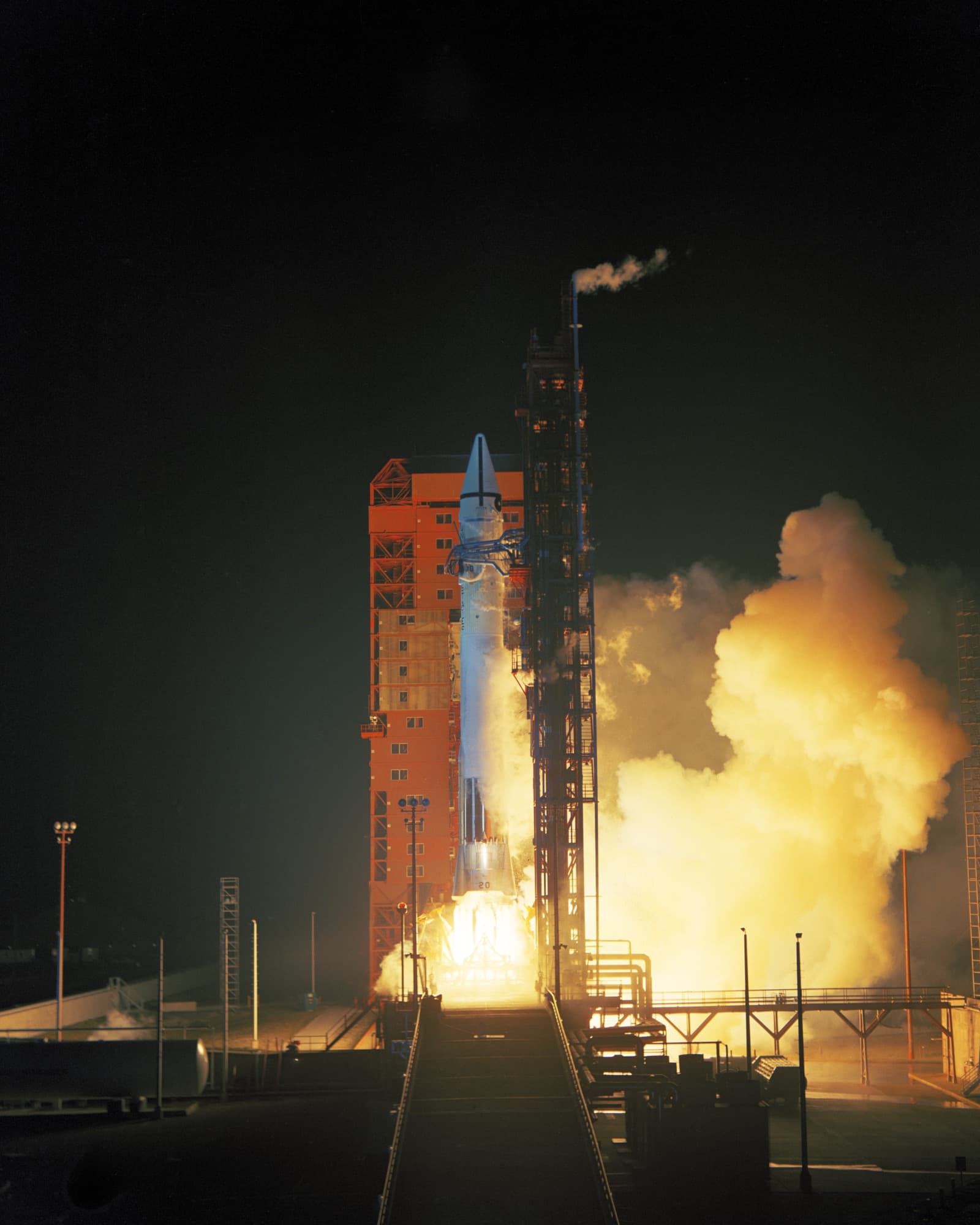
By 1969 humanity had seen Mars close up exactly once. Mariner 4 had flown past in July 1965 and sent home 22 television frames at eight and a third bits per second, a trickle so slow that the pictures took four days to arrive. Those frames covered about one percent of the planet and showed craters, which almost nobody had expected, and very little else. Mariner 6 and 7 were the answer to that: two identical spacecraft launched into the same window, aimed at flying roughly three times closer than Mariner 4 with an instrument suite more than twice as heavy. The enabling change was the rocket. Both flew on Atlas-Centaur, the first time that vehicle carried a mission to another planet, and the extra performance let each spacecraft grow to 411.8 kg against Mariner 4's 261 kg. Ten days before Mariner 6 was due to fly, on 14 February 1969, a faulty electrical relay opened the pneumatic valves on its Atlas during a simulated countdown. An Atlas is held rigid by internal pressure rather than by structure, so the unfuelled booster began to crumple with the spacecraft on top of it. Two General Dynamics technicians, Bill McClure and Jack Beverlin, ran in under twelve storeys of collapsing rocket and repressurised it by hand. They became the first recipients of the NASA Medal of Exceptional Bravery. Mariner 6 was moved to a different Atlas-Centaur and launched on schedule at 01:29:02 UTC on 25 February.
Mariner 7 followed on 27 March at 22:22:01 UTC, thirty days behind but on a faster trajectory that would bring it to Mars only five days after its twin. That five-day gap was the point of the whole design: Mariner 6 would fly first, its pictures would be analysed on the ground, and Mariner 7's encounter sequence would be rewritten in flight to chase whatever looked interesting. Each spacecraft carried an 11.8 kg Central Computer and Sequencer holding both a standard mission and a conservative backup, and both could be reprogrammed from Earth. It very nearly did not happen. On 30 July 1969, about seven hours before Mariner 6 reached Mars, the Deep Space Network station at Johannesburg lost Mariner 7's high-gain signal entirely. Seven hours of silence followed. A station at Goldstone that had been tracking Pioneer 8 picked up a faint carrier, controllers commanded the spacecraft onto its low-gain antenna, and telemetry came back, minus fifteen channels that never returned. Worse, the scan platform had lost its pointing reference, which meant the cameras could not be aimed. Engineers recalibrated by hand and had Mars back in frame on 1 August. The cause was never proven. The first guess was a micrometeoroid strike; the theory that stuck is that the silver-zinc backup battery, which failed outright a few days later, ruptured and vented electrolyte hard enough to act as a small thruster.
Mariner 6 crossed the Martian equator at 05:19:07 UTC on 31 July 1969, 3,431 km above the surface, imaging a band across Sinus Meridiani where the rover Opportunity would land in 2004. Mariner 7, its sequence rewritten to run further south and take 33 frames instead of 25, passed 3,430 km above the planet at 05:00:49 UTC on 5 August, its track running from Sinus Meridiani southeast towards Hellas and then across the south polar cap. Between them the two spacecraft returned 201 pictures and about 800 million bits of data, the close-ups covering roughly 20 percent of the surface at resolutions down to about 300 m per pixel. Each then passed behind Mars, and the way its radio signal bent going in and coming out gave the atmosphere's density profile. Kliore and colleagues measured surface pressures of 6 to 7 millibars at three of the four occultation points and 3.8 at the fourth, in Hellespontus, which they read as ground standing 5 to 6 km high. The infrared instruments confirmed that the south polar cap is mostly frozen carbon dioxide at about minus 125 C, while equatorial ground in daylight reached about plus 17 C. At least three Mariner 7 frames caught Phobos: no surface detail, but an unmistakably lumpy outline. Years later the missions paid out again, when ranging data taken as both spacecraft passed behind the Sun measured the Shapiro delay and matched general relativity to three percent or better.
Two days after the Mariner 7 flyby, the infrared spectrometer team announced that it had found methane and ammonia at the edge of the south polar cap. Walter Sullivan put it on the front page of the New York Times on 8 August 1969: two gases associated with life, found on Mars. The team retracted it within weeks. The strong absorption near 3,020 reciprocal centimetres sits almost exactly on methane's nu-3 vibration and the weaker one near 3,300 looks like ammonia, but both turned out to be previously unreported features of solid carbon dioxide more than a millimetre thick, and Kenneth Herr and George Pimentel published the correction in Science that October. The pictures misled in a quieter and more consequential way. Both spacecraft, like Mariner 4 before them, happened to fly over the ancient cratered highlands of the southern hemisphere and the equatorial belt. They did not photograph the Tharsis volcanoes and they did not photograph Valles Marineris, because neither lay in the swath. Nix Olympica, the classical bright spot that is Olympus Mons, does appear in Mariner 7's approach frames, but as an albedo marking rather than a mountain. The 1969 team was more careful than the caricature suggests: Leighton and colleagues reported in October that craters dominate but that two terrain types with no lunar counterpart were present, later named chaotic and featureless terrain. What propagated outward, into textbooks and the public mind, was the headline version: Mars is cratered, ancient and dead.
Mariner 9 settled it. Arriving in Mars orbit on 14 November 1971 into a planet-wide dust storm, it waited the storm out and then mapped nearly the whole surface, finding shield volcanoes, a canyon system thousands of kilometres long, layered polar deposits and channels that looked cut by running water. The Mariner 9 geology team wrote the epitaph for the flyby view plainly: the moonlike cratered terrain identified as the dominant surface unit from the Mariner 6 and 7 data had proven less typical of Mars than previously believed, though still extensive across the southern hemisphere's middle and high latitudes. None of which makes 1969 a failure. Mariner 6 and 7 pinned down the atmospheric pressure and composition that every later lander had to survive, confirmed that the polar caps are carbon dioxide, took what appear to be the first spacecraft images of a moon other than our own, and proved that a crippled spacecraft could be reprogrammed in flight to chase a discovery its twin had just made. They also flew a week after Apollo 11 splashed down, which is most of the reason almost nobody remembers them. Their most visible memorial is on Mars itself: the McClure-Beverlin Escarpment on the western rim of Endeavour crater, named in 2014 for the two men who kept a rocket from folding up on a February afternoon in 1969.
Mission facts
Launch (Mariner 6)
25 February 1969, 01:29:02 UTC (24 February, 20:29:02 EST), on an Atlas SLV-3C/Centaur (vehicle AC-20) from Launch Complex 36B, Cape Kennedy, Florida. The Cape carried the name Cape Kennedy from 1963 to 1973.↗
Launch (Mariner 7)
27 March 1969, 22:22:01 UTC, on an Atlas SLV-3C/Centaur (vehicle AC-19) from Launch Complex 36A, Cape Kennedy, 30 days and about 21 hours after Mariner 6. Wikipedia's infobox calls both rockets Atlas SLV-3D; NSSDCA and NASA say SLV-3C.↗
Launch mass
411.8 kg (908 lb) each. The lower figure of 381 kg (840 lb) is widely published, including in NASA's Beyond Earth chronicle, NASA's own current Mariner 6 and Mariner 7 mission pages and Wikipedia. Against it, NSSDCA gives 411.8 kg, NASA's history office gives 908 pounds, JPL's own January 1969 fact sheet says 'approximately 900 pounds' and Encyclopedia Astronautica gives 412 kg (908 lb), so 411.8 kg is used here. For comparison Mariner 4 was 261 kg.↗
Spacecraft
3.35 m tall, built on an octagonal magnesium frame 138.4 cm across the diagonal and 45.7 cm deep; solar panels spanning 5.79 m tip to tip with 17,472 cells over 7.7 square metres, giving 800 W near Earth and 449 W at Mars; a 1,200 watt-hour rechargeable silver-zinc battery for backup; a 223 N hydrazine motor for course corrections.↗
Instruments
Wide-angle and narrow-angle vidicon TV cameras (R. B. Leighton, Caltech), infrared spectrometer (G. C. Pimentel, UC Berkeley), infrared radiometer (G. Neugebauer, Caltech), ultraviolet spectrometer (C. A. Barth, Colorado), plus an S-band radio occultation experiment (A. J. Kliore, JPL) and a celestial mechanics experiment (J. D. Anderson, JPL). Those are the six listed on JPL's pre-flight fact sheet; NASA's current mission pages count seven by adding a conical radiometer, and NASA's history office counts eight by adding a thermal control flux monitor and a general relativity experiment. Science payload about 57.6 kg per NSSDCA, though the same JPL fact sheet gives 141.18 lb (64.0 kg) for the science instruments, so the figure is not settled. NSSDCA's mission-profile text calls the occultation data X-band twice; that appears to be an error, since the spacecraft carried only S-band transmitters.↗
Downlink and imaging
16,200 bit/s on the high-rate science channel, exactly 1,944 times Mariner 4's 8 1/3 bit/s. Each camera scanned a raster of 945 picture elements per line by 704 lines, read out every 42 seconds. The full raster was digitised to 6 bits per element for the composite-analogue-video version recorded on tape, which is 3,991,680 bits per picture, the figure JPL's pre-flight fact sheet quotes; a sparser digital-video version sampled every seventh element at 8 bits but had its two most significant bits truncated before transmission. Mariner 4, for comparison, sent 200 lines of 200 pixels at 6 bits. An analogue tape recorder held 195 million bits. Total data return for the pair was about 800 million bits.↗
Launch-pad accident
14 February 1969, ten days before the scheduled launch: a faulty electrical relay opened the pneumatic valves on the Atlas carrying Mariner 6 during a simulated countdown, releasing the internal pressure that gives an Atlas its rigidity. The unfuelled booster began to crumple. General Dynamics technicians Bill McClure and Jack Beverlin repressurised it by hand at the risk of what NSSDCA calls the 12-storey rocket collapsing on them, and became the first recipients of the NASA Medal of Exceptional Bravery. Mariner 6 was moved to another Atlas-Centaur and launched on time.↗
Mariner 6 encounter
31 July 1969, closest approach at 05:19:07 UTC (22:19 on 30 July at JPL in Pasadena), 3,431 km above the surface, crossing the equatorial belt over Sinus Meridiani. NASA's mission page gives 3,429 km; NSSDCA and Wikipedia give 3,431 km. Near-encounter imaging began at 05:03 UTC, and the spacecraft passed behind Mars eleven minutes after closest approach, reappearing 25 minutes later.↗
Mariner 7 encounter
5 August 1969, closest approach at 05:00:49 UTC (22:00 on 4 August in Pasadena), 3,430 km above the surface. Its more inclined track ran from Sinus Meridiani southeast towards Hellas and then across the south polar cap. Mariner 7 found the floor of Hellas devoid of craters at about 300 m resolution, a result nobody could explain until Mariner 9.↗
Pictures returned
201 in total, with the near-encounter close-ups covering roughly 20 percent of the surface at resolutions down to about 300 m per pixel. All sources agree on 126 frames for Mariner 7 (93 far-encounter and 33 near-encounter), but the Mariner 6 split is reported inconsistently: NSSDCA says 49 far-encounter and 26 near-encounter frames (plus a 50th partial far-encounter image), and NASA's history office says 50 far and 25 near, both totalling 75. NASA's own Mariner 6 mission page, however, gives 50 preliminary far-encounter photos and 24 near-encounter photos, which totals 74 and cannot be reconciled with the 201 pair total.↗
Mariner 7 in-flight anomaly
Contact was lost on 30 July 1969, about seven hours before Mariner 6's closest approach, when the Deep Space Network station at Johannesburg lost the high-gain signal. After roughly seven hours of silence a station at Goldstone that had been tracking Pioneer 8 found a faint carrier; controllers commanded the spacecraft onto its low-gain antenna. Fifteen telemetry channels never came back. The cause was never proven: a micrometeoroid strike was the first guess, a ruptured silver-zinc battery venting electrolyte like a small thruster the later favourite. The battery itself failed outright a few days before encounter.↗
Recovery and in-flight replan
The anomaly cost the scan platform its pointing reference, so the cameras could not be aimed. Ground teams recalibrated by hand and had Mars back in frame on 1 August; far-encounter imaging began on 2 August at 09:32:33 UTC and ran 57 hours by NSSDCA's account, though NSSDCA also says the sequence ended about five hours before closest approach, which those numbers do not quite give. On the strength of Mariner 6's results the near-encounter sequence was rewritten in flight to run further south and to take 33 frames instead of the planned 25, a change NASA's Mariner 7 mission page states directly and JPL's pre-flight fact sheet corroborates by budgeting twenty-five near-encounter pictures per spacecraft. The damaged spacecraft therefore returned more pictures than its healthy twin.↗
Atmosphere
Radio occultation at four points gave surface pressures of 6 to 7 millibars at three of them and 3.8 millibars at the fourth, in Hellespontus, read as ground standing 5 to 6 km above the mean (Kliore, Fjeldbo, Seidel and Rasool, Science 166, 1393, 1969). The atmosphere is predominantly carbon dioxide, about 98 percent by NASA's summary. NASA's mission page quotes 3.5 millibars and about 6 km for the fourth point; the published paper says 3.8 millibars and 5 to 6 km, which is the figure used here.↗
Polar cap and temperatures
The infrared instruments showed the south polar cap to be predominantly solid carbon dioxide, at about minus 125 C, consistent with the Leighton and Murray model of a CO2 cap in equilibrium with the atmosphere. NASA's Mariner 6 mission page gives the range as minus 73 C at night to minus 125 C at the south polar cap; the plus 17 C peak for equatorial ground in daylight comes from SpaceFlight Insider's project summary rather than from a NASA page.↗
Phobos
At least three Mariner 7 frames caught Phobos. No surface detail was visible, but the moon was clearly not round. We have found no earlier spacecraft image of a natural satellite other than Earth's own Moon, though NASA's own phrasing for this ('the first photograph of a planetary satellite taken by a spacecraft') overstates it, since spacecraft had been photographing the Moon since 1959.↗
End of mission
Both spacecraft were left in heliocentric orbit, Mariner 6 at 1.14 x 1.75 AU and Mariner 7 at 1.11 x 1.70 AU, figures given on NASA's own Mariner 6 and Mariner 7 mission pages. Sources disagree on the end: Wikipedia gives deactivation on 23 December 1970 (Mariner 6) and 28 December 1970 (Mariner 7), a pair of dates we could not trace to any NASA or NSSDCA source, while the same NASA mission pages say data were received until mid-1971. Ranging data taken as both passed behind the Sun at their conjunctions in the spring of 1970 were used to measure the Shapiro time delay, about 200 microseconds, verified 'with an uncertainty of 3 percent or less' (Anderson, Esposito, Martin, Thornton and Muhleman, Astrophysical Journal 200, 221, 1975).↗
Mission timeline
- 14 Feb 1969A faulty relay opens the pneumatic valves on the Atlas beneath Mariner 6 during a simulated countdown at Cape Kennedy. The unfuelled booster, held rigid only by internal pressure, starts to crumple. Technicians Bill McClure and Jack Beverlin run in and repressurise it by hand.
- 25 Feb 196901:29:02 UTC: Mariner 6 launches on Atlas-Centaur AC-20 from Launch Complex 36B, the first time Atlas-Centaur carries a mission to another planet. In Florida the clock still reads 24 February.
- 27 Mar 196922:22:01 UTC: Mariner 7 launches on AC-19 from Launch Complex 36A, 30 days behind its twin but on a faster trajectory that will bring it to Mars only five days later.
- 27 Mar to 2 Apr 1969The Soviet Union loses both of its M-69 Mars orbiters, the first Lavochkin Mars probes designed for the Proton rocket, in successive launch failures. The 1969 window is left entirely to NASA.
- 30 Jul 1969About seven hours before Mariner 6's flyby, the Johannesburg station loses Mariner 7's high-gain signal. Seven hours of silence follow before Goldstone finds a faint carrier and controllers switch the spacecraft to its low-gain antenna. Fifteen telemetry channels are gone for good, and the scan platform has lost its pointing reference.
- 31 Jul 196905:19:07 UTC: Mariner 6 passes 3,431 km above the Martian equator after 41 hours of approach imaging, takes 26 near-encounter frames across Sinus Meridiani, then slips behind the planet for a radio occultation.
- 1 Aug 1969Hand calibration puts Mars back into Mariner 7's camera field, four days before encounter.
- 2 Aug 196909:32:33 UTC: Mariner 7 begins 57 hours of far-encounter imaging, its near-encounter sequence rewritten in flight on the strength of what Mariner 6 has just seen. The plan now runs further south and takes 33 frames instead of 25.
- 5 Aug 196905:00:49 UTC: Mariner 7 passes 3,430 km above Mars on a more southerly track, imaging Hellas and the south polar cap. In Pasadena it is still the evening of 4 August, which is why many accounts date this flyby a day early.
- 7 Aug 1969Two days after the flyby, the infrared spectrometer team announces methane and ammonia at the edge of the south polar cap. The New York Times runs Walter Sullivan's story on page one on 8 August. Both bands turn out to belong to solid carbon dioxide. No source gives the conference an explicit date; 7 August follows from 'two days after' a 5 August UTC flyby and from the next-morning newspaper.
- 3 Oct 1969Leighton and colleagues publish the first full picture analysis in Science: craters dominate, but two terrain types with no lunar counterpart are present, later named chaotic and featureless terrain.
- 14 Nov 1971Mariner 9 enters Mars orbit. Once the global dust storm clears it finds the Tharsis volcanoes, Valles Marineris and the outflow channels, none of which the 1969 flybys had crossed, and the moonlike Mars of 1969 is retired.
A filled dot marks something that physically happened. A hollow one marks an announcement, a naming or a target.
In pictures
Tap a photo to enlarge.
Sources
- NSSDCA Master Catalog: Mariner 6 (1969-014A), archived 6 Aug 2025
- NSSDCA Master Catalog: Mariner 7 (1969-030A), archived 12 Aug 2025
- NASA Science: Mariner 7 mission page
- NASA Science: Mariner 6 mission page
- Rindfleisch, Dunne, Frieden, Stromberg and Ruiz (1971), JGR 76, 394: Digital processing of the Mariner 6 and 7 pictures
- NASA History, John Uri (31 Jul 2019): 50 Years Ago: Mariner 6 and 7 Explore Mars
- JPL: Mariner '69 Fact Sheet, 1 January 1969 (archived)
- Kliore, Fjeldbo, Seidel and Rasool (1969), Science 166, 1393-1397, 12 Dec 1969: radio occultation measurements of the atmosphere of Mars
- Herr and Pimentel (1969), Science 166, 496: Infrared Absorptions near Three Microns Recorded over the Polar Cap of Mars
- Zahnle, Freedman and Catling (2011), Icarus 212, 493: Is there methane on Mars?
- Sharp, Soderblom, Murray and Cutts (1971), JGR 76, 331: The surface of Mars 2. Uncratered terrains
- McCauley et al. (1972), Icarus 17, 289: Preliminary Mariner 9 report on the geology of Mars
- NASA Science image record: Mars full-disk approach view from Mariner 7
- Andrew LePage, Drew Ex Machina (8 Aug 2020): Meridiani Planum in 1969
Facts on this page were verified on 23 August 2026. Where sources disagree, the disagreement is stated rather than resolved silently.