Mars Global Surveyor
NASA · United States · Orbiter · 1996 · The losing decadeEnded
Mapped Mars for nine years, more than four times its planned mission. Last contact 2 November 2006, after a memory write sent in June drove a solar array into its hard stop and left the antenna pointing away from Earth.
TL;DR· 13 min read
Mars Global Surveyor was Mars Observer rebuilt at roughly a quarter of the cost, and it worked in Mars orbit for nine years. Its camera returned more than 240,000 images, its magnetometer found the fossil magnetism of a dynamo that died about four billion years ago, and MOLA measured the shape of the planet to roughly a metre. It fell silent on 2 November 2006 after a memory write sent to the wrong addresses in June disabled the solar array limits and left the antenna pointing away from Earth.
Mars Global Surveyor was Mars Observer rebuilt, at roughly a quarter of the cost, and it worked for nine years in Mars orbit. Its camera returned more than 240,000 images, its magnetometer found the fossil magnetism of a dynamo that died four billion years ago, and its laser altimeter measured the shape of the entire planet to about a metre. That height model is the terrain the Mars globe on this site is built from. It died on 2 November 2006, not of dust or cold but of a memory write sent to the wrong address the previous June.
- 9 yearsoperating in Mars orbit, over four times the planned mission
- 240,000images returned by the Mars Orbiter Camera, over 4.8 Martian years
- 463 mper pixel: the MOLA height map this site's Mars globe is displaced from
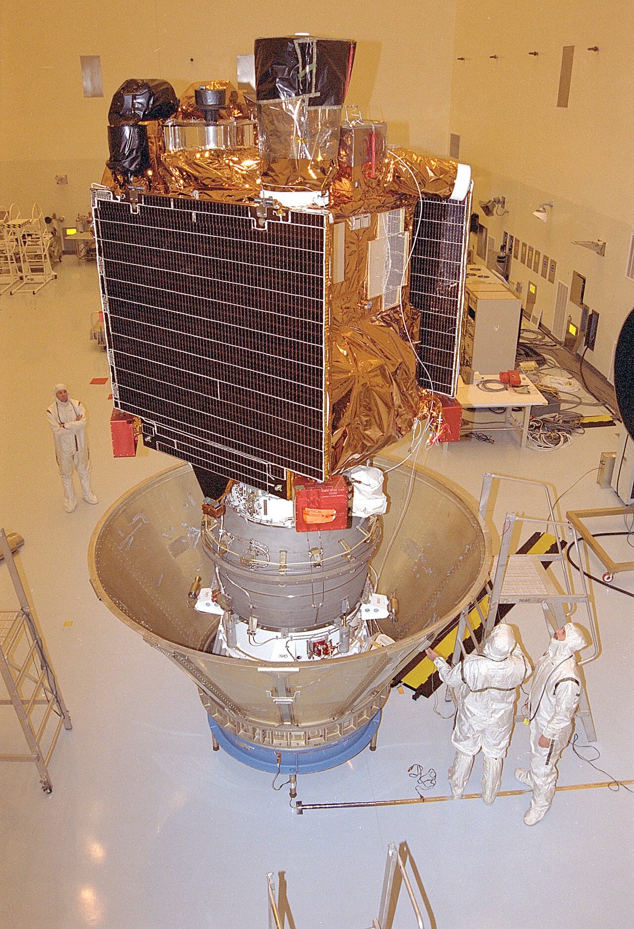
Mars Global Surveyor is the rare second attempt that came in cheaper and worked better. After Mars Observer vanished in 1993, NASA formulated the Mars Surveyor Program: one industrial partner, one spacecraft every 26-month launch window, and a hard ceiling on ambition. Global Surveyor was the first of them, and it was Mars Observer rebuilt. Its camera was the actual flight spare that Malin Space Science Systems had made for Mars Observer. Its laser altimeter, thermal emission spectrometer and magnetometer were rebuilds by the same principal investigators. Where Mars Observer had cost $813 million and flown on a Titan III, Global Surveyor cost about $154 million to build and $65 million to launch, and rode a Delta II. That choice had a consequence written into the mission design: the smaller rocket could not lift enough propellant to brake directly into a low mapping orbit, so the spacecraft would have to aerobrake, using the Martian upper atmosphere as a free brake over hundreds of passes. Magellan had demonstrated aerobraking at Venus in 1993 as an end-of-mission experiment. Global Surveyor would be the first spacecraft whose primary mission depended on it. It launched on 7 November 1996 at 17:00:49 UTC. Nine days later Russia's Mars 96, the mission that Global Surveyor's French-built relay antenna had been designed to talk to, launched, failed to leave Earth orbit, and came back down the following day.
The engine burned for 22 minutes 17 seconds on 12 September 1997, shed 973 m/s, and dropped the spacecraft into a 261 by 54,024 km capture orbit with a period of nearly 45 hours. Aerobraking started five days later. Then the mission nearly ended. One solar panel had failed to latch when it deployed after launch, and on the fifteenth aerobraking pass, on 6 October, the atmospheric density doubled without warning; the panel swung past its fully deployed position and began flexing instead of holding rigid. The cause was later traced to a fractured damper arm. Since the panels were the brakes, this was not a cosmetic problem. On 12 October the team raised periapsis from 121 to 170 km with a 2.3 m/s burn and stopped aerobraking altogether while they modelled what was happening. The eventual answer was to aerobrake far more gently, which meant far longer: a first phase to April 1998, a five-month pause in an 11.6 hour science phasing orbit, a resumption on 23 September 1998, and a finish in February 1999. Four months of planned aerobraking became seventeen. It also forced a change of orbit geometry, so that mapping ran on the 2 p.m. south-to-north crossing rather than north-to-south. Mapping formally began on 9 March 1999.
What it then found reshaped Mars. The magnetometer, working during the low aerobraking passes at 100 to 200 km, discovered that Mars has no global magnetic field now but that its ancient southern highlands are magnetised in strong, banded patterns, with no such magnetism around the Hellas and Argyre basins. That absence dates the death of the Martian dynamo to roughly four billion years ago, in the early Noachian. The camera returned more than 240,000 images across 4.8 Martian years, at 1.5 to 12 m per pixel from the narrow angle telescope, and in 2000 Malin and Edgett published gullies in crater walls and polar pits so young and so uncratered that the best explanation was liquid water seeping out and running downhill. In 2006 the same team reported twenty fresh impact craters formed between May 1999 and March 2006, and bright new deposits inside gullies that had not been there in 1999. The thermal emission spectrometer detected crystalline hematite, a mineral that usually needs water to form, and NASA credits that identification with steering the choice of a rover landing site. Global Surveyor also scouted landing sites for Spirit, Opportunity, Curiosity and Phoenix, and relayed telemetry from rovers on the ground.
The instrument that matters most to this site is MOLA. It worked by an idea simple enough to explain in a sentence: fire an infrared laser pulse straight down ten times a second, time how long the reflection takes to come back, and if you know exactly where the spacecraft was, you know exactly how high the ground is. The laser was a diode-pumped Nd:YAG putting out 40 to 45 mJ at 1064 nm, the receiver a half-metre telescope feeding a silicon avalanche photodiode, and each shot lit a patch of Mars about 160 m across. It ranged from 15 September 1997 until its timing oscillator failed on 30 June 2001, and NASA Goddard's planetary geodesy group counts almost 700 million individual footprints. Reprocessed against precision orbit solutions and crossover corrections, those points are good to roughly a metre in radius and a hundred metres in position, which for a while made Mars better surveyed than large parts of Earth. USGS assembles them into a global mosaic at about 463 m per pixel, 46,080 by 23,040 pixels, running from -8,201 m on the floor of Hellas to +21,241 m at the summit of Olympus Mons: 29,442 m of total relief. That file is the terrain this site's Mars globe is displaced from. Every ridge and basin you see is a MOLA measurement.
It died on 2 November 2006, and the way it died is worth reading carefully, because nothing broke. In September 2005 the parameter controlling where the high gain antenna should point in contingency mode was updated on the two redundant control computers at two different times, with slightly different operator-entered precision. The values were numerically equivalent for all practical purposes but not identical, and a later memory readout flagged the mismatch. The correction, uploaded in June 2006, went to the wrong memory addresses. It quietly corrupted two unrelated parameters: it disabled the solar array positioning limits, and it corrupted the contingency antenna pointing. Nothing happened for five months. Then a routine command to swing the arrays off the Sun line for thermal control drove one array into its hard stop; the fault protection concluded the gimbal was jammed and entered contingency mode; the attitude it chose put one battery in direct sunlight; the battery overheated; the power software misread the over-temperature as an overcharge and stopped charging it; and the antenna, thanks to the second corrupted parameter, was aimed away from Earth so nobody could see any of this happening. Both batteries were flat within about twelve hours. The Operations Review Board found the team had followed its procedures exactly, and that the procedures were not good enough.
Mission facts
Launch
7 November 1996 at 17:00:49 UTC (12:00:49 p.m. EST) on a Delta II 7925 (vehicle D239) from Launch Complex 17A, Cape Canaveral Air Station. NSSDCA's launch record logs 17:00:50 UTC, one second later. The launch had slipped a day because of cloud and upper level winds.↗
Why it existed
The first spacecraft of NASA's Mars Surveyor Program, formulated in 1994 to fly a Mars mission every 26 months with a single industrial partner. It carried five instruments similar to those lost with Mars Observer in 1993, and its camera was literally the Mars Observer Camera's flight spare.↗
Mass
1,030.5 kg at launch, including 216.5 kg of hydrazine and 144 kg of nitrogen tetroxide (NSSDCA). The arrival press kit separately quotes 767 kg as 'spacecraft mass at Mars arrival'. The two are not reconciled in either document. Note that some secondary sources call 1,030.5 kg a dry mass, which it is not.↗
Spacecraft
A box roughly 1.17 by 1.17 by 1.7 m in two modules, equipment and propulsion, 12 m across with the solar panels out. Two panels, each about 3.5 by 1.9 m, of gallium arsenide and silicon cells, 980 W. Two 20 amp-hour nickel-hydrogen batteries at 28 V. A 1.5 m high gain dish on a 2 m boom. Main engine thrust is given as 596 N by NSSDCA and 660 N by the arrival press kit.↗
Instruments
Mars Orbiter Camera (Michael Malin, 21 kg), Mars Orbiter Laser Altimeter (David E. Smith, 25.9 kg), Thermal Emission Spectrometer (Philip Christensen), Magnetometer/Electron Reflectometer (one sensor on the end of each solar array), a radio science investigation using an ultra-stable oscillator, and a French-supplied Mars Relay antenna built to serve future landers including Russia's Mars 96. Mars 96 launched nine days after Global Surveyor and fell back to Earth the following day.↗
MOLA
A diode-pumped, Q-switched Nd:YAG laser firing 1064 nm pulses at 10 per second, 40 to 45 mJ each, with a 0.5 m parabolic receiver and a silicon avalanche photodiode. Beam divergence 0.45 mrad, horizontal resolution about 160 m, design vertical resolution 2 m local and 30 m global. Reprocessed data are good to roughly 1 m radially and 100 m in position.↗
Mars orbit insertion
The main engine burned from 01:17:16 to 01:39:33 UTC on 12 September 1997, which is 6:17 to 6:39 p.m. PDT on 11 September. Duration 22 minutes 17 seconds, velocity change 973 m/s, from 5.09 to 4.40 km/s relative to Mars. One-way light time that day was 14 minutes 6 seconds. The capture orbit was 261 by 54,024.5 km, period 44.99 hours, inclination 93.26 degrees.↗
The broken wing
One solar panel (the -Y panel) never latched after launch. On the fifteenth aerobraking pass, 6 October 1997, atmospheric density unexpectedly doubled and the panel moved past its fully deployed position and then flexed rather than staying rigid, later attributed to a fractured damper arm and structural damage. On 12 October a 2.3 m/s burn raised periapsis from 121 to 170 km and aerobraking was suspended while the flight team modelled the panel.↗
Aerobraking
Chosen because the cheaper Delta II could not lift enough propellant to reach a low mapping orbit directly. Aerobraking began 17 September 1997 and, after the panel problem forced a slower schedule, reached an 11.6 hour science phasing orbit with a 171 km periapsis by April 1998, paused for five months, resumed 23 September 1998 and ended in February 1999. NASA's own key dates give 17 September 1997 to 19 February 1999. It took about 17 months instead of the planned four.↗
Mapping orbit
Near-circular and near-polar, 117 to 118 minute period, mean altitude 378 km, inclination about 93 degrees, Sun-synchronous with 2 a.m. and 2 p.m. equator crossings, mapping on the 2 p.m. south-to-north pass rather than north-to-south as originally planned. A seven-day near-repeat cycle produced full coverage every 26 days.↗
Mission phases
Mapping formally began 9 March 1999 (NASA) or mid-March 1999 (NSSDCA). The primary mission ran one Martian year, 687 days, and ended 1 February 2001, by which time 83,000 images had been returned, which NASA describes as more than all previous Mars missions combined. Four extensions followed; the fourth, for two more years, was granted on 1 October 2006, a month before the spacecraft died.↗
Cost
About $154 million to develop and build and $65 million to launch, with operations and data analysis running about $20 million a year (NSSDCA). The pre-launch press kit quoted $148 million development, $52.6 million launch and $46.4 million operations, and a 26-month development.↗
How it died
In June 2006 a direct memory command meant to update the high gain antenna's contingency pointing direction was written to the wrong memory address. It corrupted two independent parameters: it disabled the solar array positioning limits and it corrupted the contingency antenna pointing. On 2 November 2006 a routine command to move the arrays off the Sun line for thermal control drove one array against its hard stop; fault protection read that as a stuck gimbal and entered contingency mode; the resulting attitude put one battery in direct sunlight; the power software read the over-temperature as an overcharge and cut charging. Both batteries were depleted, probably within 12 hours, and the antenna was pointing away from Earth the whole time.↗
The root cause behind the root cause
The chain started in September 2005. The antenna's contingency positioning angle was updated on the two redundant control computers at two different times, with slightly different operator-entered precision. The difference was numerically trivial but left the two memories inconsistent. A later full memory readout exposed the mismatch, and the effort to correct it in June 2006 specified the wrong addresses. The board found the team followed existing procedures and that the procedures were inadequate to catch it.↗
End of mission
Last contact 2 November 2006. A spacecraft emergency was declared on 4 November. Deep Space Network radio science equipment running a pre-programmed schedule turned out to have recorded MGS signals a few hours after the anomaly, below the main receivers' detection threshold. From 14 November, Mars Reconnaissance Orbiter and ESA's Mars Express tried and failed to image it. NASA announced the mission was over on 21 November 2006, and formal recovery efforts were terminated on 28 January 2007.↗
The height map
MOLA ranged from 15 September 1997 until its timing oscillator failed, dated 30 June 2001 by most sources and 1 July 2001 by NASA Goddard's planetary geodesy group, which counts almost 700 million individual laser footprints. USGS builds those into the Mars MGS MOLA DEM global mosaic, 46,080 by 23,040 pixels. The USGS product page states 463.0835744 m per pixel; the downloaded file's own georeferencing works out to 463.0935 m. It spans -8,201 m in Hellas to +21,241 m on Olympus Mons, a total relief of 29,442 m. That file is the terrain this site's Mars globe is displaced from.↗
Mission timeline
- 7 Nov 199617:00:49 UTC: Launch on a Delta II 7925 from Launch Complex 17A, Cape Canaveral, after a one-day slip for weather.
- 12 Sep 199701:17:16 to 01:39:33 UTC: a 22 minute 17 second main engine burn worth 973 m/s puts the spacecraft into a 261 by 54,024 km capture orbit. Nine minutes in, Mars occults the spacecraft and the signal drops for 14 minutes.
- 6 Oct 1997On the fifteenth aerobraking pass the atmospheric density doubles unexpectedly and the unlatched solar panel bends past its fully deployed position. On 12 October a 2.3 m/s burn raises periapsis from 121 to 170 km and aerobraking is suspended.
- 23 Sep 1998Aerobraking resumes after a five-month hiatus in an 11.6 hour science phasing orbit, on a gentler schedule that spares the damaged panel.
- 19 Feb 1999Aerobraking ends and a final burn circularises the mapping orbit, 17 months after it began instead of the planned four.
- 9 Mar 1999The mapping mission formally begins from a 378 km Sun-synchronous polar orbit.
- 22 Jun 2000NASA announces the gully discovery: Malin and Edgett report young gullies in crater walls and polar pits that are best explained by groundwater seepage and surface runoff.
- 1 Feb 2001The primary mission ends after one Martian year with 83,000 images returned, and the first of four extensions begins.
- 30 Jun 2001MOLA stops ranging when its timing oscillator fails, after almost 700 million laser footprints. NASA Goddard's planetary geodesy group dates the failure to 1 July 2001; most other sources say 30 June. The rest of the spacecraft carries on for another five years.
- 1 Oct 2006On a Senior Review Board recommendation, NASA extends the mission a fourth time, for two more years.
- 2 Nov 2006A routine command to move the solar arrays off the Sun line drives one array into its hard stop. The spacecraft reports alarms, says it has stabilised, and is never heard from again. Both batteries are probably flat within 12 hours.
- 28 Jan 2007Formal recovery operations end. The Operations Review Board's preliminary report follows on 13 April 2007.
A filled dot marks something that physically happened. A hollow one marks an announcement, a naming or a target.
In pictures
Tap a photo to enlarge.
Sources
- NSSDCA Master Catalog: Mars Global Surveyor (1996-062A)
- NSSDCA: launch and trajectory information for Mars Global Surveyor
- NASA/JPL: Mars Global Surveyor Arrival press kit, September 1997
- Mars Global Surveyor Operations Review Board: 'Mars Global Surveyor (MGS) Spacecraft Loss of Contact', 13 April 2007
- NASA Release 07-88 (13 April 2007): Report Reveals Likely Causes of Mars Spacecraft Loss
- NASA Release 97-232 (14 October 1997): Global Surveyor's Orbit Raised While Solar Panel Is Analyzed
- NASA Solar System Exploration: Mars Global Surveyor, in depth
- NSSDCA Experiment: Mars Orbiter Laser Altimeter (1996-062A-03)
- NASA GSFC Planetary Geodesy and Geophysics: The Whole MOLA Catalog
- USGS Astrogeology: Mars MGS MOLA DEM global mosaic, 463 m
- Malin Space Science Systems: MGS Mars Orbiter Camera
- Smith et al. (1999), 'The global topography of Mars and implications for surface evolution', Science 284, 1495-1503
- Malin and Edgett (2000), 'Evidence for recent groundwater seepage and surface runoff on Mars', Science 288, 2330-2335
- Acuna et al. (1999), 'Global distribution of crustal magnetization discovered by the Mars Global Surveyor MAG/ER experiment', Science 284, 790-793
- Malin et al. (2006), 'Present-day impact cratering rate and contemporary gully activity on Mars', Science 314, 1573-1577
Facts on this page were verified on 23 August 2026. Where sources disagree, the disagreement is stated rather than resolved silently.