Chandrayaan-1
ISRO (India) · Orbiter · 2008Success
Mission ended Aug 29, 2009 (IST) when contact was lost 312 days in, with about 95% of objectives met; JPL ground radar located the derelict orbiter still circling at about 200 km in 2016-17.
TL;DR· 8 min read
Chandrayaan-1 was India's first Moon mission, launched October 22, 2008 and silenced after 312 days in lunar orbit, with NASA crediting it with at least 95% of its objectives. Its NASA-built M3 spectrometer found water and hydroxyl bound in sunlit lunar soil, Mini-SAR reported ice signatures in more than 40 shadowed north polar craters, and its Moon Impact Probe struck the south polar highlands beside Shackleton crater. In 2016 ground radar caught the dead orbiter still circling at about 200 km.
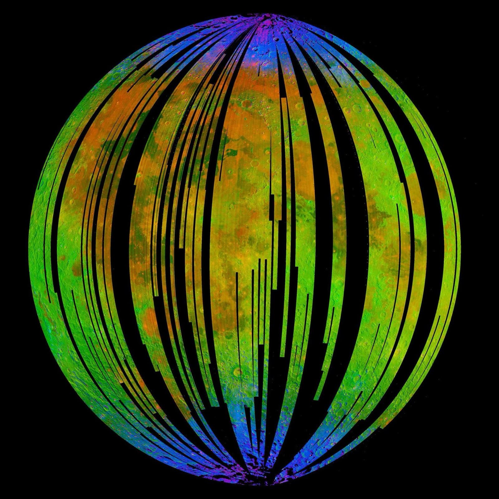
Chandrayaan-1 was India's first mission to the Moon, and it delivered discovery far out of proportion to its roughly $78 million price: the NASA-built M3 spectrometer aboard found water and hydroxyl bound in sunlit lunar soil, its Moon Impact Probe struck the south polar highlands beside Shackleton crater, and its radar sniffed out polar ice. And no, NASA did not "find the lost Chandrayaan-1 alive" in 2017: ground radar proved the dead orbiter was still circling the Moon. A derelict was located; nothing was recovered.
Facts as of July 20, 2026, from the sources listed below.
1st
Indian mission to the Moon
11
instruments from India, the US, the UK, Germany, Sweden and Bulgaria
312days
in lunar orbit, of a planned two years
$78M
approximate mission cost (about Rs 3.8 billion)
Commonly wrong. Four persistent errors in English coverage. (1) The 2017 story gets inflated: headlines like "NASA finds India's lost Moon mission" slide into implications that Chandrayaan-1 was recovered, recontacted or found operating. It was a ground-radar technique demonstration: the spacecraft has been dead since August 2009, the detection actually happened on July 2, 2016 (announced March 9, 2017), and nothing was or could be reactivated. (2) Water attribution flattens in both directions: "India discovered water on the Moon" and "NASA discovered water on the Moon" are both half-right. The headline discovery came from NASA's M3 instrument flying on India's spacecraft, published alongside corroborating Cassini and Deep Impact data, and it found hydroxyl and water molecules bound in sunlit soil: no liquid water, no ice sheets. Separately, ISRO's CHACE instrument measured water vapor during the impact probe's descent, announced only after the M3 result and peer-reviewed in 2010. (3) The impact coordinates are quoted as if settled: most pages carry 89.76 S, 39.40 W (the UN registration value), ISRO's own 2015 atlas says 89.54 S, 44.71 W, and the 2021 image-matching analysis puts Jawahar Point at about 89.55 S, 122.93 W on the Connecting Ridge; near the pole those longitudes are closer on the ground than they look, but mixing the estimates without dates is wrong, and the crater has never been found in LROC images. (4) "India's first Moon landing": the Moon Impact Probe was a deliberate hard impact and was never meant to land; India's first soft landing was Chandrayaan-3 in 2023, and India was the fifth space agency to reach the lunar surface (fourth nation to place its flag), after the USSR, the US, Japan and ESA.
01Mission facts
Launch
October 22, 2008, 00:52 UT, on PSLV-XL (flight C11) from the Satish Dhawan Space Centre, Sriharikota↗
Spacecraft
1,380 kg at launch, 700 W of power, designed for two years in a 100 km circular polar orbit↗
Mission cost
About Rs 3.8 billion (roughly $78 million at launch), which BBC noted was considerably less than Japan's and China's 2007 lunar orbiters↗
Instruments
11 from six countries: five Indian (TMC, HySI, LLRI, HEX and the Moon Impact Probe) plus NASA's M3 and Mini-SAR, the UK-led C1XS, Germany's SIR-2, Sweden's SARA and Bulgaria's RADOM↗
Moon Impact Probe
A 35 kg box carrying a descent camera, a radar altimeter and the CHACE mass spectrometer, with the Indian flag painted on its side panels; released November 14, 2008, it struck near Shackleton crater at 15:01 UT↗
Impact site (refined 2021)
About 89.55 S, 122.93 W, on the Earth-facing slope of the Connecting Ridge between Shackleton and De Gerlache craters; earlier published estimates (89.76 S, 39.40 W in the UN registration; 89.54 S, 44.71 W in ISRO's 2015 atlas) differ, and the crater itself has never been found in LROC images↗
M3 water discovery
OH and H2O absorption near 3 micrometers detected across sunlit soils, strongest toward the poles; published in Science online September 24, 2009 (Pieters et al.), alongside corroborating Cassini VIMS and Deep Impact observations↗
CHACE water vapor
The Moon Impact Probe's mass spectrometer measured water vapor in the thin sunlit lunar ambience during its 25-minute descent on November 14, 2008; the peer-reviewed result appeared in Planetary and Space Science in 2010 (Sridharan et al.)↗
Mini-SAR polar ice
Radar signatures consistent with water ice found in more than 40 small permanently shadowed craters (2 to 15 km) near the north pole, announced March 2010; NASA's estimate was at least 600 million metric tons↗
Mission end
Last contact at 20:00 UT on August 28, 2009 (01:30 IST August 29, the date ISRO uses); NASA credits the mission with at least 95% of its objectives↗
On-orbit tally
312 days in lunar orbit, more than 3,400 orbits of the Moon and over 70,000 images returned↗
Found again (2017)
JPL beamed microwaves at the Moon from the 70 m Goldstone dish and caught echoes at Green Bank: the derelict crossed the beam on July 2, 2016, still in a roughly 200 km polar orbit circling every 2 hours 8 minutes; announced March 9, 2017↗
Site: 89.5500°S, 122.9300°W · Jawahar Point (Jawahar Sthal), Earth-facing slope of the Connecting Ridge between Shackleton and De Gerlache craters (source)
02Mission timeline
22 Oct 2008
Launched at 00:52 UT on PSLV-C11 from Sriharikota, the first flight of the uprated PSLV-XL
8 Nov 2008
Enters lunar orbit: India's first spacecraft at the Moon
12 Nov 2008
Reaches its 100 km circular polar mapping orbit
14 Nov 2008
Moon Impact Probe strikes near Shackleton crater at 15:01 UT after a roughly 25-minute descent, imaging and sampling the exosphere all the way down
26 Apr 2009
Star tracker fails; ISRO flies on with gyroscopes plus antenna-pointing data and landmark imaging
19 May 2009
Orbit raised from 100 km to 200 km for wider-swath imaging and lunar gravity studies
28 to 29 Aug 2009
Contact lost abruptly (20:00 UT Aug 28; 01:30 IST Aug 29); the mission ends after 312 days
24 Sep 2009
The M3 water and hydroxyl result is published online in Science and announced by NASA
Mar 2010
Mini-SAR results announced: ice signatures in 40-plus shadowed north polar craters
2010
CHACE's in-descent water vapor measurement is published in Planetary and Space Science
2 Jul 2016
The derelict physically crosses a Goldstone-Green Bank radar beam above the lunar north pole, proving it is still in orbit (announced 9 Mar 2017)
Aug 2018
M3 data yields the first direct evidence of exposed water ice inside polar cold traps (Li et al., PNAS)
Mar 2021
LPSC analysis relocates the Moon Impact Probe's impact point to the Connecting Ridge slope at about 89.55 S, 122.93 W
Teal dots: events that physically happened in flight or on the Moon. Grey: announcements, namings, contracts, and targets.
03The mission
Chandrayaan-1 ('Moon craft' in Sanskrit) was India's first mission to the Moon, launched on October 22, 2008 at 00:52 UT from Sriharikota on PSLV-C11, the first flight of the uprated PSLV-XL that would later carry India's Mars Orbiter Mission. It arrived in lunar orbit on November 8 and settled into a 100 km circular polar orbit by November 12, joining the international return-to-the-Moon wave of the late 2000s alongside Japan's Kaguya and China's Chang'e 1. What set the 1,380 kg spacecraft apart was its manifest: 11 instruments from six countries, including NASA's Moon Mineralogy Mapper (M3) and Mini-SAR radar, European payloads from the UK, Germany and Sweden, and a Bulgarian radiation monitor, all flown for about Rs 3.8 billion, roughly $78 million.
Two days after reaching its mapping orbit, on November 14, 2008 (the birthday of Jawaharlal Nehru, India's first prime minister), the spacecraft released its 35 kg Moon Impact Probe. Over a roughly 25-minute descent the probe took more than 3,000 images, measured its altitude by radar and sampled the wisp-thin lunar exosphere with its CHACE mass spectrometer before striking the south polar highlands beside Shackleton crater at 15:01 UT. The Indian flag was painted on its side panels, and Indian coverage marks the moment India became the fourth country to place its flag on the Moon; counting agencies whose hardware had reached the surface, it was the fifth, after the USSR, the US, Japan (Hiten, 1993) and ESA (SMART-1, 2006). The impact site is named Jawahar Point (Jawahar Sthal). Exactly where it lies took 13 years to pin down: the UN registration says 89.76 S, 39.40 W, ISRO's 2015 science atlas says 89.54 S, 44.71 W, and a 2021 analysis that matched the final probe images against LROC mosaics moved the point to about 89.55 S, 122.93 W on the Earth-facing slope of the Connecting Ridge between Shackleton and De Gerlache, terrain later studied for Artemis landings. The impact crater itself has never been identified in orbital imagery.
The science that made the mission famous arrived after the spacecraft died. On September 24, 2009, Science published the M3 team's detection of hydroxyl and water molecules bound in sunlit lunar soil, strongest toward the poles, corroborated in the same issue by re-examined Cassini and Deep Impact flyby data. ISRO could add a twist: CHACE had directly measured water vapor in the lunar ambience during the Moon Impact Probe's descent ten months earlier, a result announced only after NASA's and peer-reviewed in Planetary and Space Science in 2010. In March 2010, the Mini-SAR team reported radar signatures consistent with water ice in more than 40 permanently shadowed craters near the north pole, with a NASA estimate of at least 600 million metric tons. The thread kept running long afterward: in 2018, researchers using M3 data published the first direct evidence of exposed water ice inside polar cold traps, and Chandrayaan-1's Mini-SAR and M3 maps were among the datasets NASA weighed in aiming the LCROSS impact that excavated water from Cabeus in October 2009.
The flight itself was a fight. The star tracker failed on April 26, 2009, forcing ISRO to steer by gyroscopes, antenna-pointing data and landmark imaging. On May 19, 2009 the orbit was raised to 200 km, giving wider imaging swaths and cleaner gravity measurements. Then, abruptly, radio contact dropped at 20:00 UT on August 28, 2009 (01:30 IST on August 29, the date ISRO cites), and the mission was declared over: 312 days in lunar orbit instead of the planned two years, more than 3,400 orbits, over 70,000 images, and, by NASA's accounting, at least 95% of the mission objectives already met.
The strangest chapter came seven years later. In 2016, JPL tested whether ground radar could find small derelicts in lunar orbit, a hard problem because the Moon's lumpy gravity slowly scrambles old orbits and Chandrayaan-1 is a cube barely 1.5 meters across. The team transmitted microwaves from the 70 m Goldstone antenna and listened with the Green Bank Telescope, pointing just above the lunar north pole; on July 2, 2016 something crossed the beam on schedule, and repeated passes over three months confirmed it was Chandrayaan-1, still in a roughly 200 km polar orbit, circling every 2 hours and 8 minutes. The result, announced on March 9, 2017, was a technique demonstration for future mission planning. Nothing was rescued: the spacecraft has been silent since 2009, and as of 2026 those radar echoes remain the last direct evidence of it. Its real afterlife is the program it started, which continued through Chandrayaan-2's orbiter and the Chandrayaan-3 landing of 2023, and the water story every south polar mission since has been chasing.
04In pictures
Tap a photo to enlarge.
05Sources
- NASA Science: Chandrayaan-1 / Moon Impact Probe mission page (launch, orbit dates, MIP impact time, last contact, 95% of objectives)
- ISRO: Chandrayaan-1 mission page (1,380 kg, 11 instruments, 100 to 200 km orbit, 3,400 orbits, contact lost Aug 29, 2009)
- ISRO: Chandrayaan-1 science results (MIP 35 kg and instruments, CHACE water evidence, TMC and SARA findings)
- ISRO: PSLV-C11 mission page (XL configuration with six 12-tonne PSOM-XL strap-ons)
- Gunter's Space Page: PSLV-XL launch record (C11 as the first PSLV-XL flight)
- BBC News, Oct 22, 2008: India launches first Moon mission (cost 3.8 billion rupees / $78M)
- eoPortal: Chandrayaan-1 (312 days, star tracker failure Apr 26, 2009, orbit raise May 19, 2009, 70,000+ images)
- Pieters et al. 2009, Science: Character and Spatial Distribution of OH/H2O on the Surface of the Moon Seen by M3 on Chandrayaan-1 (published online Sep 24, 2009)
- NASA/JPL news, Sep 24, 2009: NASA Instruments Reveal Water Molecules on Lunar Surface
- Sridharan et al. 2010, Planetary and Space Science: 'Direct' evidence for water in the sunlit lunar ambience from CHACE on MIP
- NASA Science / Mini-RF: NASA Radar Finds Ice Deposits at Moon's North Pole (Mar 2010, 40+ craters, 600 million metric tons)
- Spudis et al. 2010, GRL: Initial results for the north pole of the Moon from Mini-SAR, Chandrayaan-1 mission
- NASA/JPL news, Mar 9, 2017: New NASA Radar Technique Finds Lost Lunar Spacecraft (Jul 2, 2016 detection, 200 km orbit)
- Li et al. 2018, PNAS: Direct evidence of surface exposed water ice in the lunar polar regions (from M3 data)
- NASA/JPL news, Aug 2018: Ice Confirmed at the Moon's Poles
- Stooke et al., LPSC 2021 abstract 1013: Chandrayaan-1 Moon Impact Probe impact location refined (89.55 S, 122.93 W)
- For All Moonkind Moon Registry: Chandrayaan-1 (MIP 35 kg, instruments, flag on side panels)
- The Planetary Society: Chandrayaan-1, India's first Moon mission
azmth is independent and is not affiliated with or endorsed by NASA, CNSA, Roscosmos, ISRO, JAXA, or any other space agency or company named on this page.