Chang'e 1
CNSA (China) · Orbiter · 2007Success

Controlled impact in Mare Fecunditatis Mar 1, 2009, 08:13 UTC, after 16 months in orbit; the impact scar was later identified in LROC images at 1.66 S, 52.27 E (Icarus, 2019).
TL;DR· 7 min read
Chang'e 1 was China's first Moon mission and its first spacecraft to leave Earth orbit. Launched October 24, 2007, it mapped the entire Moon at 120 m per pixel and carried the first microwave radiometer flown to lunar orbit, returning 1.37 TB of raw science data. The March 1, 2009 crash into Mare Fecunditatis was a planned, ground-commanded rehearsal for the landings that followed, and the impact scar was later identified in LROC images at 1.66 S, 52.27 E.
Chang'e 1 was China's first Moon mission and its first spacecraft ever to leave Earth orbit, the opening move of the Chang'e program arc that runs through this catalog to far-side landings and sample returns. It mapped the entire Moon with a 120 m stereo camera and, in a world first, a microwave radiometer that took the whole surface's temperature at four frequencies. And its March 1, 2009 crash was no failure: the impact was a deliberate, ground-commanded rehearsal for the landings that followed, and the scar was later found in LROC images 5 to 6 km from the announced spot.
Facts as of July 20, 2026, from the sources listed below.
16months
in lunar orbit, four beyond the one-year design life
120m/px
resolution of China's first full-Moon image map
1.37TB
raw science data returned from eight instruments
1.4Byuan
mission cost, about 180 million dollars in 2007
Commonly wrong. Three recurring errors in English coverage. (1) The impact coordinates: most pages still quote the announced 1.50 S, 52.36 E; the actual scar, a fan of bright ejecta beside a small, probably pre-existing crater, was identified in LROC images at 1.66 S, 52.27 E (Stooke, Icarus 2019), 5 to 6 km to the southwest and about 4.4 km from the trajectory-based prediction. (2) 'Crashed' read as failure: the March 1, 2009 impact was a planned, ground-commanded deorbit carried out 16 months into a 12-month design life, explicitly to bank experience for the program's landing phase. (3) The fake-photo flap: when the first image was unveiled in November 2007, bloggers accused China of copying 'a 2005 NASA image'; the comparison image was actually 1994 Clementine data, and independent analysis showed the Chinese mosaic was genuine. The 'suspicious extra crater' is a seam artifact of cosmetic mosaicking, and no forgery was involved. A gentler fourth: 'first complete map of the Moon' needs its qualifier, since the November 2008 product was China's first full-Moon image map and the microwave map was a world first, but global imaging itself had been done before, by Clementine among others.
01Mission facts
Launch
October 24, 2007, 10:05 UTC, Long March 3A from Launch Complex 3, Xichang Satellite Launch Center↗
Spacecraft
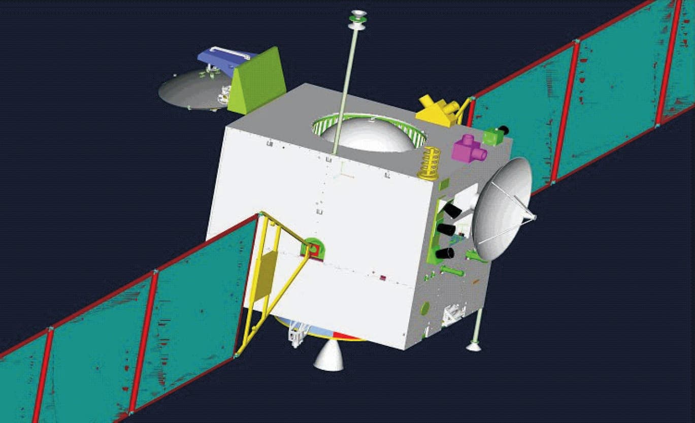
Built on the DFH-3 communications-satellite bus; 2,350 kg at launch, 1,150 kg dry↗
Working orbit
200 km circular polar orbit, 127-minute period; captured November 5, 2007, final circularization November 7↗
First for China
China's first spacecraft to depart Earth orbit; only the USSR/Russia, the US, ESA and Japan had flown lunar missions before↗
Science payload
Eight instruments, about 140 kg: CCD stereo camera (120 m, 60 km swath), laser altimeter, imaging interferometer spectrometer, gamma-ray and X-ray spectrometers, microwave radiometer, high-energy particle detector, two solar wind ion detectors↗
Microwave first
First microwave radiometer flown to lunar orbit (channels at 3.0, 7.8, 19.35 and 37 GHz); produced the first microwave map covering the entire lunar surface↗
Full-Moon map
China's first map of the entire lunar surface, published November 12, 2008, from stereo camera coverage acquired November 2007 to July 2008↗
ESA tracking support
ESA's ESTRACK stations at Maspalomas, Kourou and New Norcia tracked Chang'e 1 from November 1, 2007, through translunar flight and the orbit-insertion burns, covering stretches when China's own stations could not see the spacecraft↗
Mission cost
1.4 billion yuan, about 180 million dollars at the time↗
Data returned
1.37 TB of raw science data, processed into about 4 TB of standard data products↗
Controlled impact
March 1, 2009, 08:13 UTC, in Mare Fecunditatis; braking began at 07:36 UTC on commands from the Qingdao and Kashi stations; announced coordinates 1.50 S, 52.36 E; described by China's space administration as planned and controlled, to bank experience for the landing phase↗
Impact site identified
A fan of bright ejecta at 1.66 S, 52.27 E, spraying past a 15 m crater that is probably pre-existing, found by Phil Stooke by comparing a 1972 Apollo 16 panoramic-camera frame with LROC images; about 4.4 km from the trajectory-based prediction (published in Icarus, 2019)↗
Site: 1.6600°S, 52.2700°E · Chang'e 1 impact site, northern Mare Fecunditatis (source)
02Mission timeline
Jan 2004
First phase of the Chang'e program, the lunar orbiter, is formally approved, opening China's lunar exploration effort
24 Oct 2007
Launch at 10:05 UTC on a Long March 3A from Xichang Satellite Launch Center
31 Oct 2007
Trans-lunar injection after a week of phasing-orbit burns around Earth
5 Nov 2007
Lunar orbit insertion: China's first spacecraft in orbit around another world
7 Nov 2007
Third braking burn settles the orbiter into its 200 km, 127-minute circular polar working orbit
20 to 21 Nov 2007
CCD stereo camera shoots the 19 frames of China's first lunar image, highlands near Mare Australe
26 Nov 2007
Premier Wen Jiabao unveils the first image at the Beijing Aerospace Control Center
12 Nov 2008
China publishes its first map of the entire lunar surface, built from a year of stereo camera coverage
6 Dec 2008
Orbit lowered from 200 km to 100 km
19 Dec 2008
Perilune dropped to 15 km, rehearsing the low passes later landing missions would need
1 Mar 2009
Controlled impact in Mare Fecunditatis at 08:13 UTC, commanded through the Qingdao and Kashi stations
1 Oct 2010
Chang'e 2, built from Chang'e 1's backup spacecraft with technical improvements, launches from Xichang
Feb 2017
Phil Stooke identifies the impact scar in LROC images, an ejecta fan at 1.66 S, 52.27 E; the identification is published in Icarus in 2019
Teal dots: events that physically happened in flight or on the Moon. Grey: announcements, namings, contracts, and targets.
03The mission
Chang'e 1 carries more program weight than any single dataset it returned. Approved in January 2004 as phase one of a deliberately incremental orbit-land-return roadmap, it was built on the DFH-3 communications-satellite bus, cost about 1.4 billion yuan (roughly 180 million dollars), and launched on a Long March 3A from Xichang on October 24, 2007, a month after Japan's Kaguya and a year before India's Chandrayaan-1 in that decade's Asian return to the Moon. The spacecraft spent a week raising its apogee through phasing orbits, left Earth orbit on October 31, was captured by the Moon on November 5, and settled into its 200 km circular polar working orbit, 127 minutes per revolution, on November 7. No Chinese spacecraft had operated beyond Earth orbit before, and the mission leaned on ESA's ESTRACK network, with Maspalomas, Kourou and New Norcia tracking the flight from November 1 through the stretches when China's own tracking stations could not see the spacecraft.
The roughly 140 kg payload packed eight instruments. A three-line CCD stereo camera mapped the Moon at 120 m per pixel across a 60 km swath, a laser altimeter built the companion topographic model, an imaging interferometer spectrometer and gamma-ray and X-ray spectrometers worked on surface composition, and particle detectors sampled the near-Moon radiation and solar wind environment. The signature instrument was the four-channel microwave radiometer, the first ever flown to lunar orbit: by reading the regolith's microwave brightness temperature at 3.0, 7.8, 19.35 and 37 GHz it sensed heat from below the optical surface and produced the first microwave map covering the entire Moon, a dataset used to estimate regolith thickness globally. The first image, a 19-frame mosaic of highlands near Mare Australe shot on November 20 and 21, 2007, was unveiled by Premier Wen Jiabao five days later, and the spacecraft beamed back recordings of 30 Chinese songs from lunar orbit for good measure.
By its first anniversary in orbit Chang'e 1 had met its science and engineering goals, and China published the full-Moon image map on November 12, 2008. Then the mission turned into a flight school. On December 6, 2008 controllers dropped the orbit from 200 to 100 km, and on December 19 they pushed the perilune down to 15 km, flying the kind of low pass a landing descent would one day begin from. The ending was written the same way: at 07:36 UTC on March 1, 2009 the spacecraft began braking on commands relayed through the Qingdao and Kashi tracking stations, and at 08:13 UTC it struck northern Mare Fecunditatis, with the announced coordinates 1.50 S, 52.36 E. China's space administration described the impact as planned and controlled, banked as experience for the soft landing to come; 1.37 TB of raw science data were already home.
The impact scar took eight years to find. Trajectory reconstruction by Liu Jianjun and colleagues pointed near 1.80 S, 52.23 E, and planetary cartographer Phil Stooke finally spotted the site by blinking a 1972 Apollo 16 panoramic-camera frame against modern LROC images and looking for anything new. What appeared was a fan of bright rays at 1.66 S, 52.27 E, spraying past a 15 m crater that was probably already there: the fan itself is the smeared signature of a low, grazing impact that struck the old crater or the ground just beside it; it dug no neat new bowl. The site lies about 4.4 km from the predicted point and 5 to 6 km southwest of the announced coordinates. The identification, published in Icarus in 2019, puts it about 120 km west of where Luna 16 drilled its 1970 sample, which is why the two pins sit close together on this site's globe.
As the opening move of the Chinese Lunar Exploration Program, Chang'e 1 is the ancestor of every CLEP entry in this catalog. Its backup spacecraft flew as the improved Chang'e 2 in October 2010 and scouted the landing zone for Chang'e 3, which in 2013 made the first lunar soft landing anywhere in 37 years; the program then landed on the far side, returned samples from both hemispheres, and points next at the lunar south pole and an eventual crewed landing. The 2007 orbiter's own products read modestly beside all that, a 120 m global map in an era when Kaguya and LRO soon mapped far finer, but the microwave survey was a world first, and the mission proved out the deep-space tracking, navigation and control that everything since has stood on. Wu Weiren, then the lunar program's chief designer, framed impact day plainly: the second phase aimed at a soft landing, and the preparation was already in progress.
04In pictures
Tap a photo to enlarge.
05Sources
- CNSA English (Xinhua): China's lunar probe Chang'e-1 impacts moon (impact time, coordinates, Qingdao/Kashi control, purpose, Wu Weiren quote)
- CNSA English (China Daily): Milestones mark the way to moon exploration (January 2004 approval, first full-surface map, Chang'e 2 as backup)
- eoPortal: Chang'e-1 (bus, masses, orbit, instrument suite, orbit lowering, 1.37 TB, first whole-Moon microwave map)
- ESA: Chang'e 1, new mission to Moon lifts off (launch-day report: rocket and launch site)
- ESA: ESA tracking support essential to Chinese mission (Maspalomas/Kourou/New Norcia, support from November 1, 2007)
- Planetary Society / Lakdawalla: Chang'e 1 returns its first image from the Moon (Nov 20-21 capture, Nov 26 unveiling, first Chinese craft beyond Earth orbit)
- Planetary Society / Lakdawalla: No, the Chang'e image isn't fake! (December 2007 debunk of the copied-image accusation)
- Planetary Society / Lakdawalla: The Chang'e 1 mission is over (impact context, 120 km west of Luna 16)
- Planetary Society / Stooke: Finding spacecraft impacts on the Moon (identification method, 1.66 S 52.27 E, Liu prediction 1.80 S 52.23 E, Apollo 16 pan-camera comparison)
- Stooke 2019, Icarus 319, pp. 334-336: Identification of the Chang'E 1 spacecraft impact site on the Moon (ejecta fan, pre-existing 15 m crater, offset from prediction)
- Space.com: China's First Moon Probe Crashes to Lunar Surface (1.4 billion yuan / ~$180M cost, mission recap)
- Wikipedia: Chang'e 1 (launch time and complex, trans-lunar injection, full-map date, songs, mass)
- Li et al. 2010, Science China Earth Sciences: The global image of the Moon obtained by Chang'E-1 (map data coverage November 2007 to July 2008)
azmth is independent and is not affiliated with or endorsed by NASA, CNSA, Roscosmos, ISRO, JAXA, or any other space agency or company named on this page.