Mapping Mars, and the Canals
Schiaparelli's 1877 canali meant channels. English made them canals, Lowell made them a civilisation, and Mariner 4 ended it in 1965.
TL;DR· 30 min read
There are no canals on Mars and nobody ever saw one. Nearly all the straight lines drawn between 1877 and the 1960s were the eye assembling detail below what the telescopes could resolve, which Maunder and Evans demonstrated on about two hundred schoolboys in 1902 and 1903, and Mariner 4 ended the argument in public on 15 July 1965. The names survived: 613 of the 2,052 Martian names the IAU had approved as of 24 August 2026 descend from the telescopic map.
Nobody built canals on Mars, and nobody ever saw one. Nearly all the straight lines that hundreds of astronomers drew between 1877 and the 1960s were manufactured by the human eye assembling detail that sat just below what their telescopes could resolve, a mechanism demonstrated experimentally on schoolboys in 1902 and 1903, and confirmed by every spacecraft since. The place names are the opposite case. They are real, they are older than most people think, and most of them were invented by the same man who drew the canals: Schiaparelli's 1877 map gave Mars Syrtis Major, Hellas, Elysium, Chryse and Solis Lacus, and those are still the official names of those places. This page is about how the map got made, how one Italian noun became a seventy-year mistake, and who decides where zero is.
- 0canals ever found on Mars, by any spacecraft, in sixty years of looking
- 613 of 2,052official Mars names descended from the telescopic map, as of 24 August 2026
- 0.5 or 0.8 kmAiry-0, the crater that fixes zero longitude; the IAU publishes both sizes
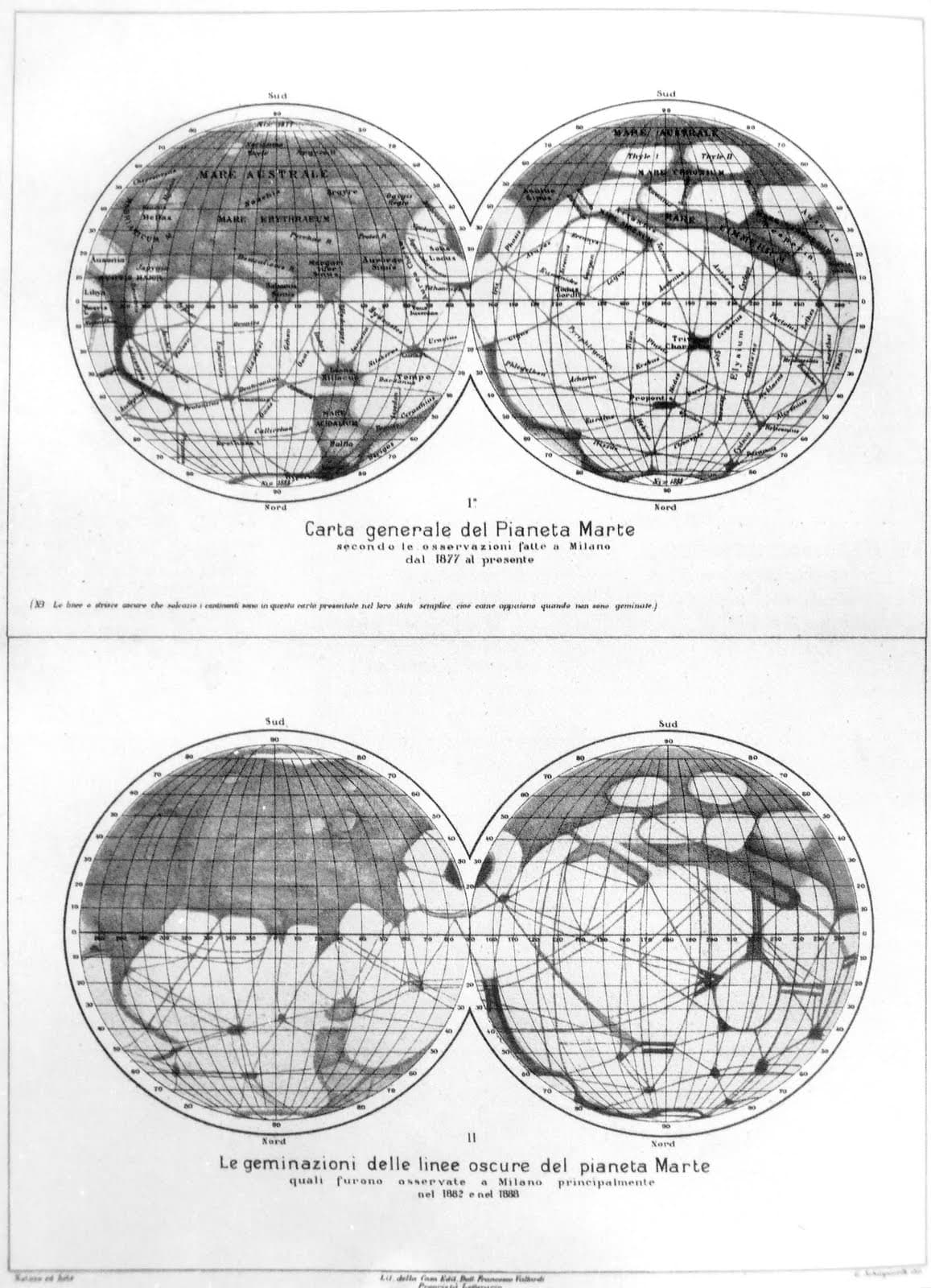
Mars was mapped for two centuries before anyone drew a canal on it. Christiaan Huygens pointed a telescope at the planet on the evening of 28 November 1659, saw a dark V-shaped patch and sketched it. The patch was Syrtis Major, and it is still there and still called that. Three days later it had come back to almost the same place, and Huygens noted that the rotation of Mars ought to take about a day, 24 of our hours, just as the Earth's does. Cassini, at the 1666 opposition and unaware of Huygens's unpublished result, tracked spots for thirty-six days and got 24 hours 40 minutes, within three minutes of the truth. Herschel read a paper to the Royal Society on 11 March 1784 deriving the Martian axial tilt as 28 degrees 42 minutes, against the modern 25.19, explaining the polar caps as seasonal ice, and closing with the sentence that set the tone for the next 180 years: Mars "has a considerable but moderate atmosphere, so that its inhabitants probably enjoy a situation in many respects similar to ours". None of them named anything. Beer and Madler published the first real map in 1840 and pointedly used letters rather than names; their feature "a" is why zero longitude on Mars is where it is, and everything on this globe is still counted from a hole in the ground inside it. Proctor put the first names on a Mars map in 1867, all astronomers, and they lasted ten years. Then on 12 September 1877, a week after a perihelic opposition, Giovanni Virginio Schiaparelli set out with an 8.6-inch Merz refractor on the roof of the Brera Palace in Milan, fixing sixty-two points micrometrically rather than by eye.
He threw out Proctor's names, because under a better instrument the features had shifted, shrunk and multiplied, and replaced them with a nomenclature drawn from classical Mediterranean geography and myth: Syrtis Major, Sinus Sabaeus, Solis Lacus, Mare Sirenum, Hellas, Ausonia, Libya, Aeria, Arabia, Chryse, Tharsis, Elysium. Names went on being added at the oppositions that followed, Nix Olympica among them on 10 November 1879. Most of the large-scale map of Mars still carries those words. In the same memoir he recorded a network of fine dark linear markings, and for those he borrowed a term Angelo Secchi had used since 7 May 1858, when Secchi called Syrtis Major the Atlantic Canale. Canali is Italian for channels or grooves as readily as for canals, and Schiaparelli meant natural ones; he used fiume, river, as a synonym. Eighteen years later he set it out plainly: the streaks were called canali not without some reason, though the name must be understood in a very broad sense, and rather than true canals of the sort familiar to us we should imagine shallow depressions of the ground, running straight for thousands of kilometres, over widths of 100 or 200 km or even more. Those widths should have killed the argument on arrival. His own figures run from under 30 km for the faintest lines to 200 or 300 km for the Nilosyrtis, on a planet 6,792 km across. A 300 km ditch is not something a civilisation digs; it is something a continent does. English took the word as canals anyway. Nor was Schiaparelli a pure bystander to the myth that followed. In 1895 he published a long speculation about a Martian population managing the annual meltwater flood, but flagged it himself: what follows, he wrote, will not have the value of a scientific result, and will indeed border in part on fiction.
Percival Lowell drew no such line. He was given Camille Flammarion's La Planete Mars as a Christmas present in December 1893, read it at speed and scrawled "Hurry" across a page. By January 1894 he had recruited William Pickering and A. E. Douglass from Harvard and was paying their salaries; Douglass went west in March with a 6-inch refractor to test the seeing across Arizona; Lowell settled on Flagstaff on 16 April; and on 22 May 1894 he told the Boston Scientific Society that his object was an investigation into the habitability of other worlds and that "there is strong reason to believe that we are on the eve of pretty definite discovery in the matter". He arrived at Flagstaff on 28 May and looked at Mars for the first time on 31 May. He announced the conclusion and then went to collect the observations. Over the next twenty-two years he built the case out across three books, Mars in 1895, Mars and Its Canals in December 1906, dedicated to Schiaparelli as "the Columbus of a new planetary world", and Mars as the Abode of Life in 1908. The core argument is elegant and checkable. A rotating planet's surface is in fluid equilibrium, so there is no downhill; yet the seasonal darkening moves from latitude 72 north to the equator in fifty-two days and then crosses into the other hemisphere; therefore, he wrote, the water is "artificially helped to its end". His physics was where it broke. He computed a mean Martian temperature of 48 degrees Fahrenheit, almost exactly that of southern England, and a surface pressure of 2.5 inches of mercury, about 85 millibars. The real figure is 6.36.
Everything needed to refute him was already in print, most of it published in the season he started. Between 29 June and 10 August 1894, on ten nights, W. W. Campbell put a spectroscope on the Lick 36-inch and compared Mars against the Moon at matched altitudes and matched humidity. The two spectra seemed identical in every respect, and the observations furnished no evidence whatever of a Martian atmosphere containing water vapour. Campbell was careful: that set an upper limit, roughly a quarter of Earth's atmosphere, rather than proving an absence, and he still thought the polar caps proved water was there. In the same months Edward Emerson Barnard, on the same telescope, confided to Simon Newcomb that to save his soul he could not believe in the canals as Schiaparelli drew them, and that they would be proved a fallacy within a few oppositions. In the same year Maunder published the summation hypothesis: that the canals were the eye's assembly of a complexity of detail too fine to be separately discerned. On 4 January 1897 Vincenzo Cerulli, in a moment of perfect definition, watched the canal Lethes lose its form of a line and break into a system of minute patches. Then in 1902 and 1903 Maunder and J. E. Evans, headmaster of the Greenwich Hospital School, ran the experiment. They hung up diagrams of Mars, most with no canals on them, only dots and irregular smudges, and had classes of about twenty boys who knew nothing about astronomy, some two hundred in all, draw them from various distances. The boys at the front drew the smudges. The boys at the back drew only the broad dark markings. The boys in the middle drew a network of straight lines with dots at the junctions, in the right places. Lowell called it the small boy theory.
The canals should have ended in 1909, when Antoniadi looked at Mars through the 83 cm Meudon refractor during a seven-hour temperature inversion over Paris and found detail from which "geometry was conspicuous by its complete absence". Among astronomers they largely did. In public they did not. Lowell died on 12 November 1916 still convinced, and at his observatory Earl C. Slipher went on photographing Mars until 1964, more than 100,000 images across twenty-seven oppositions, certain to the last that his plates proved the canals real. His late-1950s map, canal network and all, was adopted by the United States Air Force as its official Mars chart for spacecraft missions. That is the map the space age began with. Mariner 4 flew past on 15 July 1965 and sent home 21 complete frames plus part of a 22nd, about one per cent of the surface: a densely cratered landscape and nothing else. NASA still describes the result as having "incontrovertibly quash[ed] any expectations of lost civilizations on the planet". Two years later the IAU approved its first three spacecraft-derived Martian names, all craters in that strip: Ejriksson, Mariner and Nansen. Then Mariner 9 mapped the whole planet and in 1973 the IAU adopted 272 names in one sitting, among them Olympus Mons, Valles Marineris and craters for nearly everyone in this story. As of 24 August 2026 the gazetteer holds 2,052 approved Martian names and 613 of them descend from the telescopic map. For how names are approved now, see the place names of Mars.
The honest summary is that the map was right and the lines on it were not. The classical layer survived because it was never a claim about anything: Syrtis Major is a dark region, and calling it the Libyan Gulf commits you to nothing. The canali were a claim, and claims can be wrong. What is worth holding onto is how the mistake worked, because it was not stupidity and it was not really a translation error either. Schiaparelli was the most careful areographer of his generation and his names are still in force. Green, Denning, Barnard and Antoniadi looked at the same regions in the same decades and drew soft irregular shading, and the profession spent thirty years unable to decide which of them was seeing correctly, because before planetary photography there was no way to arbitrate between two skilled observers except by argument. The eye at the threshold of resolution really does manufacture straight lines, which is exactly what the Greenwich schoolboys demonstrated. Add a charismatic amateur with a private observatory, a fortune, three popular books and a conclusion published before he had ever looked, and you get seventy years of a dying civilisation irrigating a drying world. Three Martian valles are still officially named after Lowell's canals, Nia, Pallacopas and Surius, all adopted in 1991 with the gazetteer's origin field opening "Lowell canal name". They are the only canals on Mars, and they are canals in name only.
What we know
The first drawing of a place on Mars
Christiaan Huygens, on the evening of 28 November 1659 at 7 p.m., with Mars near opposition showing a disk 17.3 arcseconds across (the circumstances are Sheehan's; the words are Huygens's). His manuscript records "Mars observatus cum hujusmodi maculis", Mars observed with spots of this kind, alongside a sketch of a dark V-shaped marking that is unmistakably Syrtis Major. On 1 December the same marking was back in nearly the same place, and he concluded "deberet igitur Martis conversio fieri spatio circiter diurno sive 24 horarum nostrarum quem admodum et telluris": the rotation of Mars ought therefore to take about a day, or 24 of our hours, just as the Earth's does. The first thing humans ever learned about the surface of Mars was that it turns like ours.↗
Cassini in 1666, Herschel in 1784
Giovanni Domenico Cassini observed the aphelic opposition of 19 March 1666 with a Campani telescope of 5.2 m focal length, tracked spots for thirty-six or thirty-seven days until they returned to the same positions at the same hour of night, and got a rotation period of 24 hours 40 minutes, within three minutes of the truth and entirely independent of Huygens, whose result was unpublished. William Herschel read a paper to the Royal Society on 11 March 1784 (Philosophical Transactions vol. 74, pp. 233 to 273) deriving "the obliquity of the ecliptic on the globe of Mars" as 28 degrees 42 minutes, against the modern 25.19, explaining the polar caps as seasonal ice, and closing: "And that planet has a considerable but moderate atmosphere, so that its inhabitants probably enjoy a situation in many respects similar to ours." Dated Datchet, 1 December 1783.↗
The first map, the first names, and where zero longitude came from
Wilhelm Beer, a Berlin banker, and Johann Heinrich Madler, working from the 1830 opposition with a 95 mm Fraunhofer refractor, established that most Martian markings are permanent and in 1840 published the first true map of the planet. They deliberately refused to name anything, designating features with letters: Syrtis Major was efh, and a small round patch 8 degrees south of the equator was "a". They used "a" as their reference point for timing the rotation. Schiaparelli adopted it as his zero of longitude in 1877, Camille Flammarion named the region Sinus Meridiani, and it has defined zero on Mars ever since. Names proper arrived in 1867, when Richard Anthony Proctor drew a map from William Rutter Dawes's 1864 sketches and christened the features after the observers who had studied the planet: "I have applied to the different features the names of those observers who have studied the physical peculiarities presented by Mars." It was heavily English and heavily repetitive. Dawes alone received an ocean, a continent, a sea, a strait, an isle and a forked bay; Syrtis Major was the Kaiser Sea and Hellas was Lockyer Land. The scheme lasted ten years and left nothing on the modern map.↗
Schiaparelli's 1877 campaign
Mars came to a perihelic opposition on 5 September 1877, about 56 million km away. Schiaparelli had an 8.6-inch (22 cm) Merz refractor installed on the roof of the Brera Palace in Milan in 1874, and had intended only to test whether it was good enough for planetary work. On 12 September 1877 he decided instead to make a new map. He worked at 322x, and rather than estimating positions by eye he measured the longitudes and latitudes of sixty-two recognisable points micrometrically, which is why his map beat everything before it. He discarded Proctor's names because the features had shifted, shrunk and multiplied under the better instrument, and built a nomenclature out of classical Mediterranean geography and myth. The 1877 memoir gave Mars Syrtis Major, Sinus Sabaeus, Margaritifer Sinus, Aurorae Sinus, Solis Lacus, Mare Sirenum, Mare Cimmerium, Mare Tyrrhenum, Hellas, Ausonia, Libya, Aeria, Arabia, Eden, Chryse, Tharsis and Elysium. The rest of the classical map came at the oppositions that followed. Nix Olympica, for one, he named on 10 November 1879, for a whitish patch half an arcsecond across in what we now call Tharsis, and we could not establish 1877 dates for Utopia, Amazonis or Arcadia.↗
What Schiaparelli meant by canali, and how wide he said they were
Writing in Italian for the magazine Natura ed Arte in 1893 and 1895 he was explicit. The dark streaks, he says in 1895, "non senza un po' di ragione furon chiamate canali, quantunque tal nome si debba intendere in senso assai largo. Piuttosto che veri canali della forma a noi più familiare, dobbiamo immaginarci depressioni del suolo non molto profonde, estese in direzione rettilinea per migliaia di chilometri, sopra larghezza di 100, 200 chilometri od anche più": they were called canali not without some reason, though the name must be taken in a very broad sense; rather than true canals of the kind most familiar to us we must imagine shallow depressions of the ground running straight for thousands of kilometres, across widths of 100 or 200 km or even more. His stated widths run from under 30 km for the faintest to 200 or 300 km for the Nilosyrtis, on a planet 6,792 km across. He also used fiume, river, as a synonym, and by 1895 had settled on the view that what we see is not water at all but "zone di vegetazione", zones of vegetation flanking real channels too narrow to resolve from Earth. The strangest part of his record is gemination, a canal splitting along its whole length into two parallel tracks running "con tracciamento geometricamente tanto esatto, quanto suole esser presso di noi quello di due rotaje di ferrovia", as geometrically exact as a pair of railway rails. His published separations between the two tracks run from 600 km and more down to under 50 km, and the width of each line from about 30 km to more than 100. He noted that geminations appeared mainly in the months around the equinoxes, so they could not be permanent geography. The dating of the episode is in the timeline.↗
The word was not his, and neither was the translation
The Jesuit astronomer Angelo Secchi, observing from the Collegio Romano with a 24 cm refractor at the 1858 opposition, described "a large triangular patch, blue in color" on 7 May 1858 and named it the "Atlantic Canale", saying it "seems to play the role of the Atlantic which, on Earth, separates the Old Continent from the New". That is the first use of the term for a Martian feature, applied to what we now call Syrtis Major, and it caused no trouble at all. Schiaparelli borrowed it nineteen years later for his fine lines. Italian canale covers channel, groove, duct and canal alike; English took the one reading that implies an excavation, and the connotation of artificial waterways travelled with it.↗
Schiaparelli speculated about Martians too, and said so
The tidy version of this story has Schiaparelli as an innocent bystander to a mistranslation. He was not quite. In the 1895 Natura ed Arte article he sets out at length how an intelligent population might manage the single annual flood from the melting northern cap, and whether "i fenomeni dei cosi detti canali e delle loro geminazioni possano rappresentare il lavoro di una simil popolazione", whether the canali and their geminations could represent the work of such a population. What separates him from Lowell is the sentence immediately after: "Cio che diremo non avra il valore di un risultato scientifico, ed anzi confinera in parte col romanzo." What we are about to say will not have the value of a scientific result, and will indeed border in part on fiction. He labelled his own speculation. Lowell published his as a conclusion.↗
Lowell announced his conclusion before he looked
Percival Lowell received Flammarion's La Planete Mars as a Christmas gift in December 1893, read it at speed and scrawled "Hurry" across a page. In January 1894 he recruited William Pickering and Andrew Ellicott Douglass from Harvard on one-year leaves he paid for himself. Douglass went west in early March with a 6-inch refractor to test the seeing at Tombstone, Tucson, Tempe, Phoenix, Prescott, Ash Fork and finally Flagstaff; Lowell chose Flagstaff on 16 April. On 22 May 1894 he told the Boston Scientific Society that his object was "an investigation into the condition of life on other worlds, including last but not least their habitability by beings like [or] unlike man", adding that "there is strong reason to believe that we are on the eve of pretty definite discovery in the matter". He arrived at Flagstaff on 28 May and saw Mars through a telescope for the first time on 31 May, with a 12-inch borrowed from Harvard. The order of those two dates is the whole of Lowell.↗
What Lowell actually argued, and the numbers he used
Three books: Mars (1895), Mars and Its Canals (Macmillan, published December 1906, dedicated to "G. V. SCHIAPARELLI, THE COLUMBUS OF A NEW PLANETARY WORLD"), and Mars as the Abode of Life (1908). The core argument is geometric. A rotating planet's surface is in fluid equilibrium, so there is no downhill; yet the canal-quickening "occupies fifty-two days, as evidenced by the successive vegetal darkenings to descend from latitude 72 degrees north to latitude 0, a journey of 2650 miles", a speed of fifty-one miles a day; therefore the water "is artificially helped to its end". In the 1906 book he analyses 109 canals statistically, about 100 drawings each, 10,900 separate determinations. His physical numbers were the weak point. It is Wallace, auditing him in 1907, who records that Lowell "brings down the mean temperature of Mars to 48 degrees F., which is almost exactly the same as that of the southern half of England" and "reduced the probable density of the atmosphere of Mars to 2-1/2 inches of mercury, or only one-twelfth of that of the Earth". Two and a half inches of mercury is about 85 millibars, against the 6.36 millibars at mean radius on NASA's fact sheet today. Lowell's conclusion: "That Mars is inhabited by beings of some sort or other we may consider as certain as it is uncertain what those beings may be."↗
The counter-evidence, and most of it dates from 1894
In the very season Lowell began, three independent lines of evidence went against him. W. W. Campbell observed the spectrum of Mars on ten nights between 29 June and 10 August 1894 with the Lick 36-inch, comparing it against the Moon at matched altitudes and at humidities from 15 to 55 per cent, and reported that "the spectra of Mars and our Moon, observed under favorable and identical circumstances, seem to be identical in every respect" and that the observations "furnish no evidence whatever of a Martian atmosphere containing aqueous vapor". He was careful about what that did not show. His second numbered result states that the observations "do not prove that Mars has no atmosphere similar to our own; but they set a superior limit", roughly a quarter of Earth's, and he added that he still believed the polar caps were "conclusive evidence of an atmosphere and aqueous vapour", merely not in quantities a spectroscope could reach. Edward Emerson Barnard, on the same telescope, confided to Simon Newcomb: "To save my soul I can't believe in the canals as Schiaparelli draws them. I see details where some of his canals are, but they are not straight lines at all." And Edward Walter Maunder published the argument that the canals were, in the wording he used for it himself in 1913, "simply the summation of a complexity of detail too minute to be separately discerned"; he dates that conclusion to 1894. On 4 January 1897 Vincenzo Cerulli, at his own observatory near Teramo, watched the canal Lethes in a moment of perfect definition as it "lost its form of a line and altered itself into a complex and indecipherable system of minute patches".↗
The schoolboy experiment, 1902 and 1903
Maunder and J. E. Evans, headmaster of the Greenwich Hospital School, tested the summation hypothesis directly. Maunder's own account: they hung up a diagram based on a drawing by Schiaparelli or Lowell "but the canals were not inserted; only a few dots or irregular markings were put in here and there", and about two hundred boys, chosen because they were "keen-sighted, well drilled; accustomed to do what they were told without asking questions; and they knew nothing whatsoever of astronomy", were placed at different distances and told to draw exactly what they saw. Those at the front detected the little irregular markings and drew them in their true forms. Those at the back of the room saw nothing of them and drew only the broadest features, the continents and seas. Those in the middle were too far off to define the minute markings but near enough for them to make an impression, and that impression "always was of a network of straight lines, sometimes with dots at the points of meeting", falling in the proper places. The paper is Evans and Maunder, "Experiments as to the actuality of the 'canals' observed on Mars", MNRAS vol. 63, p. 488, June 1903, and it is less tidy than the retelling: thirteen experiments between 1 July 1902 and 22 May 1903, most of them in the spring of 1903, each with a class of usually twenty boys aged mostly twelve to fourteen, drawing one of several different diagrams. A few diagrams carried faint canals, drawn canals or short wavy lines so the results could be compared, and the authors report that whenever a boy drew a canal, something on the original had given rise to it. Sheehan records Lowell's response: he was unimpressed by the "small boy theory" and argued the question should be decided not by experiments but by "actual observation directed to that end".↗
1907 and 1909: the two blows that finished it among astronomers
Alfred Russel Wallace, co-discoverer of natural selection, published Is Mars Habitable? in 1907 as a point-by-point demolition of Lowell's thermal arithmetic. His verdict, in the book's last line: "Mars, therefore, is not only uninhabited by intelligent beings such as Mr. Lowell postulates, but is absolutely UNINHABITABLE." Then observation caught up. On 20 September 1909, with a seven-hour temperature inversion sitting over Paris, Eugene Antoniadi turned the 83 cm Henry refractor at Meudon, the largest in Europe, on Mars for the first time. "The first glance cast at the planet on September 20 was a revelation," he wrote. "The planet appeared covered with a vast and incredible amount of detail held steadily, all natural and logical, irregular and chequered, from which geometry was conspicuous by its complete absence." Lowell's reply was that a large aperture blurs continuous detail into apparent patches, and that Antoniadi should stop down the telescope.↗
Why the canals outlived the evidence by fifty years
Lowell died on 12 November 1916 of an intracerebral haemorrhage, still convinced. His observatory kept going. Earl C. Slipher, Flagstaff's Mars photographer, obtained more than 100,000 images covering twenty-seven oppositions between 1905 and his death in 1964, and remained a firm believer in the canals, whose existence he was convinced his photographs proved. Sheehan records the consequence plainly: his map from the late 1950s "was adopted by the U.S. Air Force as its official chart for use with its Mars spacecraft missions", and it is covered with a Lowellian canal network. That is the map the space age started with, and it is why so many people alive in 1965 still expected canals. The persistence of the idea in the press, rather than in observatories, has itself become a research subject: Richard de Grijs's 2026 studies of Australian newspapers trace a shift from an early emphasis on disciplined observation and measurement to later contested interpretation around the canals, and, in a companion paper on humour, argue that newspapers used jokes to "entertain speculative ideas while marking the limits of scientific credibility".↗
Mariner 4, and the three names it left behind
Mariner 4 passed 9,846 km above Mars on 15 July 1965 and returned 21 complete frames plus part of a 22nd, covering roughly one per cent of the surface. NASA's own sources do not agree with each other on the details: the mission page counts "21 images (plus 22 lines of a 22nd image)" where the NSSDCA catalogue says 21 lines, and the same sentence times closest approach as "08:00:57 p.m. EDT on July 14, 1965 [01:00:57 UT July 15]", two values an hour apart, since 8 p.m. EDT is 00:00:57 UT. NSSDCA prints the same clock time as EST, which is consistent with 01:00:57 UT, so the UT figure is the one we use; the line count is the part the two sources genuinely do not settle. The Mariner 4 page sets both discrepancies out. What the strip showed was craters and no canals; Leighton, Murray, Sharp, Allen and Sloan reported in Science on 6 August 1965 (Mariner IV Photography of Mars: Initial Results, vol. 149 no. 3684, pp. 627 to 630) that the surface is densely cratered, with craters up to at least 120 km across. NASA's summary is still blunt: the pictures showed "Mars to be an ancient Moon-like body with widespread cratering, thus incontrovertibly quashing any expectations of lost civilizations on the planet." In 1967 the IAU approved exactly three new Martian names, the first ever taken from spacecraft data, and all three are craters inside the strip Mariner 4 photographed: Ejriksson (46.6 km), Mariner (156.6 km, "Named for Mariner IV spacecraft") and Nansen (74.6 km).↗
What the telescope left on the map
In 1958 an ad hoc IAU committee chaired by Audouin Dollfus "recommended for adoption the names of 128 albedo features (bright, dark, or colored) observed through ground-based telescopes", based on "a system of nomenclature developed in the late 19th century by the Italian astronomer G.V. Schiaparelli (1879) and expanded in the early 20th century by E. M. Antoniadi (1929)". The gazetteer's dataset today holds 126 albedo features rather than 128, 125 of them dated 1958 and Tharsis added in 1973; three of the 1958 names have left the list since, and the gazetteer does not say which or why. There are also 487 other features whose stated origin refers back to a classical albedo name. That is 613 of the 2,052 approved Martian names as of 24 August 2026, just under a third of the map. Three valles carry Lowell canal names outright, all adopted in 1991: the gazetteer's origin field reads "Lowell canal name; also classical river name" for Nia Vallis and Pallacopas Vallis, and "Lowell canal name" for Surius Vallis.↗
Airy-0, and how well zero is actually known
When Mariner 9 mapped Mars at about 1 km resolution in 1972, Merton Davies of the RAND Corporation computed the control network and picked a small crater on the floor of the crater Airy, in Sinus Meridiani, to be the zero of longitude. Airy itself, 43.05 km across, was named in 1973 for George Biddell Airy, who built the Greenwich transit circle in 1850 that defines zero on Earth. The little one was formalised as Airy-0 in 2003. Its size is not agreed, and the disagreement is inside the IAU's own gazetteer: the Airy-0 feature page lists a diameter of 0.50 km against its point geometry and 0.79 km against its mapped outline, while the downloadable nomenclature dataset gives 0.78573 km. The smaller figure is the original: Malin Space Science Systems, describing Davies's choice, calls it "a 0.5-kilometer-wide crater (0.3 miles wide)". It was imaged once by Mariner 9 (frame 533B03), once by Viking 1 in 1978 (746A46), and then took Mars Global Surveyor nine attempts, the ninth on orbit 8280, 13 January 2001, when the spacecraft finally passed directly over it. From that image and from Viking mosaics, W0, the angle that fixes the prime meridian in space, was set at 176.630 degrees at J2000, the simple average of two determinations, 176.634 and 176.627. The stated uncertainty is 0.003 to 0.004 degrees, "or about 250 m on the Martian surface", and the authors write that they believe it unlikely to be improved upon "until a radio transmitter (lander) can be placed in the vicinity of Airy-0, presumably at some point in the distant future".↗
What happened, and when
- 28 Nov 1659Christiaan Huygens sketches a dark V-shaped marking on Mars, the feature now called Syrtis Major. Francesco Fontana had drawn the disk two decades earlier, but nothing on it is identifiable; this is the first drawing of a recognisable feature on another planet's surface. Three days later he concludes from its return that Mars turns in about 24 hours, like the Earth.
- 11 Mar 1784William Herschel reads his Mars paper to the Royal Society, deriving an axial tilt of 28 degrees 42 minutes, explaining the polar caps as seasonal ice, and stating that the planet's "inhabitants probably enjoy a situation in many respects similar to ours". The Earth-like reading of Mars is now the default, and stays the default for 180 years.
- 1830 to 1840Wilhelm Beer and Johann Heinrich Madler, using a 95 mm Fraunhofer refractor, establish that the markings are permanent and publish the first map of Mars. They refuse to name anything, using letters instead. Their small round patch "a" becomes the zero of longitude and is later named Sinus Meridiani by Flammarion.
- 7 May 1858Angelo Secchi, at the Collegio Romano in Rome, calls Syrtis Major the "Atlantic Canale" because it "seems to play the role of the Atlantic which, on Earth, separates the Old Continent from the New". The first canale on Mars is a broad dark region and nobody objects. Nine years later Richard Proctor puts the first real names on a Mars map, all of them astronomers.
- 12 Sep 1877One week after a perihelic opposition, Schiaparelli decides to map Mars with the 8.6-inch Merz refractor on the roof of the Brera Palace. He fixes sixty-two points micrometrically, invents the classical nomenclature the planet still uses, and records a network of fine dark lines he calls canali.
- 19 Jan to 19 Feb 1882Schiaparelli records the gemination of no fewer than twenty canali in a single month, beginning on 19 January when the Jamuna appears as two straight parallel lines. The first instance he had seen was the Nilus, between Lunae Lacus and Ceraunius, at the 1879 opposition: "To see it as two tracks regular, uniform in appearance, and exactly parallel, came as a great shock." He writes that he has taken all possible precautions to avoid any chance of illusion and is "absolutely certain" of what he has observed. Other observers with bigger telescopes cannot agree on it: at Lick in 1890 only Schaeberle sees a few canals double, while Keeler and Holden, on the same 36-inch, see broad, diffuse bands.
- 22 May 1894Percival Lowell tells the Boston Scientific Society what he expects to find on Mars, six days before arriving at his new observatory in Flagstaff and nine days before first looking at the planet. In the same year W. W. Campbell finds the spectrum of Mars identical to the Moon's, E. E. Barnard sees nothing artificial on it with the largest refractor on Earth, and E. W. Maunder publishes the argument that the canals are the eye summing unresolved detail.
- 1902 to 1903Maunder and J. E. Evans put diagrams of Mars, most with the canals left out and only dots or small irregular markings in their place, in front of classes of about twenty Greenwich Hospital School boys at varying distances, some two hundred boys in all. The boys in the middle of the room draw a network of straight lines that is not there. The result is published in MNRAS vol. 63, p. 488. Lowell calls it "the small boy theory".
- 20 Sep 1909Eugene Antoniadi turns the 83 cm Meudon refractor on Mars during a rare seven-hour atmospheric inversion over Paris and reports detail "all natural and logical, irregular and chequered, from which geometry was conspicuous by its complete absence". Two years earlier Alfred Russel Wallace had published a book concluding that Mars is "absolutely UNINHABITABLE". Among astronomers the canals are finished.
- 1958An ad hoc IAU committee under Audouin Dollfus adopts 128 albedo names taken from Schiaparelli's 1879 system as extended by Antoniadi in 1929. Utopia, Elysium, Hellas, Chryse, Amazonis, Arcadia and Nix Olympica become official. Meanwhile at Flagstaff, E. C. Slipher's canal-covered map of Mars is being adopted by the US Air Force as its official chart.
- 15 Jul 1965Mariner 4 flies 9,846 km above Mars and returns 21 complete frames plus part of a 22nd, about one per cent of the surface. They show a densely cratered landscape and nothing else. NASA's own description of the result is that it "incontrovertibly quash[ed] any expectations of lost civilizations on the planet". Two years later the IAU approves three crater names from the strip: Ejriksson, Mariner and Nansen.
- 1972 to 2003Mariner 9 maps the whole planet at about 1 km resolution. Merton Davies builds the control network and designates a small crater inside Airy as the zero of longitude. In 1973 the IAU adopts 272 Martian names at once, including Olympus Mons, Valles Marineris and craters for nearly everyone in this story. The zero-point crater is formally named Airy-0 in 2003.
In pictures
Tap a photo to enlarge.
Sources
- G. V. Schiaparelli, La vita sul pianeta Marte, collecting Il pianeta Marte (Natura ed Arte, 1893) and La vita sul pianeta Marte (Natura ed Arte, 1895)
- Percival Lowell, Mars and Its Canals (Macmillan, December 1906)
- Alfred Russel Wallace, Is Mars Habitable? (Macmillan, 1907)
- E. Walter Maunder, Are the Planets Inhabited? (Harper, 1913)
- W. W. Campbell, The Spectrum of Mars, Publications of the Astronomical Society of the Pacific vol. 6 no. 37 (August 1894)
- William Herschel, On the remarkable Appearances at the Polar Regions of the Planet Mars, the Inclination of its Axis, the Position of its Poles, and its spheroidical Figure, Philosophical Transactions vol. 74 (1784), read 11 March 1784, in The Scientific Papers of Sir William Herschel vol. I
- Christiaan Huygens, Oeuvres completes tome XV, Manuscript K, astronomical observations 1657-1659
- William Sheehan, The Planet Mars: A History of Observation and Discovery (University of Arizona Press, 1996), archived online edition
- William Sheehan, The Planet Mars, chapter 8, archived online edition
- Richard de Grijs, Mars in the Australian Press, 1875-1899, Paper 1 (arXiv 2603.23563), Journal of Astronomical History and Heritage 29(1):160-189 (2026)
- Gazetteer of Planetary Nomenclature: History of Planetary Nomenclature
- Gazetteer of Planetary Nomenclature: MARS_nomenclature_center_pts
- T. C. Duxbury, R. L. Kirk, B. A. Archinal and G. A. Neumann, Mars Geodesy/Cartography Working Group Recommendations on Mars Cartographic Constants and Coordinate Systems, ISPRS Commission IV (2002)
- Malin Space Science Systems, MGS MOC release MOC2-273, The Martian Prime Meridian: Longitude Zero (31 January 2001), archived
- R. B. Leighton, B. C. Murray, R. P. Sharp, J. D. Allen and R. K. Sloan, Mariner IV Photography of Mars: Initial Results, Science 149(3684):627-630, 6 August 1965
- NASA Science: Mariner 4 mission page
- J. E. Evans and E. Walter Maunder, 'Experiments as to the Actuality of the Canals observed on Mars', Monthly Notices of the Royal Astronomical Society 63(8):488-499, 12 June 1903 (doi:10.1093/mnras/63.8.488), scanned issue
- Carl Sagan and Paul Fox, 'The Canals of Mars: An Assessment after Mariner 9', Icarus 25:602-612, August 1975 (NTRS abstract)
- Edward Clinton Ezell and Linda Neuman Ezell, On Mars: Exploration of the Red Planet 1958-1978, NASA SP-4212 (1984), archived PDF
- NASA NSSDCA Master Catalog: Mariner 4 (1964-077A), archived copy
- Richard de Grijs, Mars excitement in Australian newspapers, 1877-1899: Humour and the public negotiation of astronomical knowledge, Journal of Astronomy in Culture 4(1) (2026) (arXiv 2603.22906)
Checked on 24 September 2026. Where the science is unsettled this page says so rather than picking a winner.