Phoenix
NASA · United States · Lander · 2008 · The long occupationEnded
Landed 25 May 2008 at 68.22 N in the Martian arctic, touched and analysed water ice and measured 0.4 to 0.6 percent perchlorate in the soil. Last signal 2 November 2008; NASA formally ended the mission on 24 May 2010.
TL;DR· 18 min read
Phoenix landed in the Martian arctic at 68.22 N on 25 May 2008, flying the airframe of the cancelled Mars Surveyor 2001 lander, and touched and analysed water ice directly, confirming what Mars Odyssey had inferred from orbit in 2002. It also found 0.4 to 0.6 percent perchlorate in the soil, a result nobody had asked for, which reopened the argument about what the Viking landers detected in 1976. Its last signal came on 2 November 2008 and NASA formally ended the mission on 24 May 2010.
Phoenix is the mission NASA assembled out of its own wreckage. Its airframe was built for Mars Surveyor 2001, cancelled after the twin disasters of 1999 and left bagged in a storage container at Lockheed Martin; three of its instruments came from that cancelled lander and three more were rebuilds of designs lost with Mars Polar Lander. It came down in the arctic plains on 25 May 2008, farther north than any spacecraft had landed on Mars, dug through a few centimetres of soil to a sheet of water ice, melted a sample and confirmed by mass spectrometry what Mars Odyssey had only inferred from orbit in 2002. It also found perchlorate, a result nobody had asked for, which forced a reopening of the argument about what the Viking landers detected in 1976. Five months later the sun went away and it died where it stood.
- 1sttime Martian water was touched and tasted, in JPL's phrase
- 0.4 to 0.6%perchlorate by mass in the soil, the result that reopened the Viking argument
- 68.2 Nlanding latitude, farther north than any spacecraft had landed on Mars
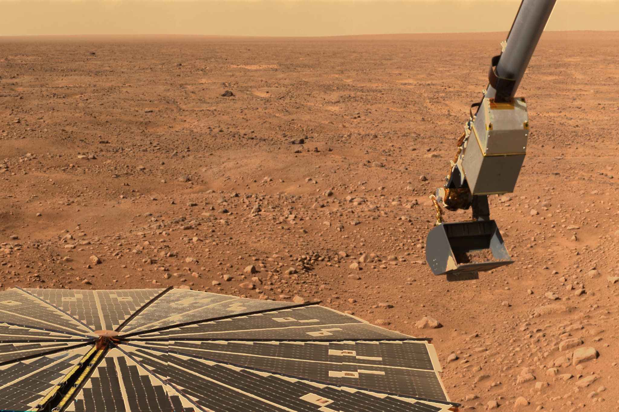
Phoenix began as a spacecraft that had already been cancelled. When Mars Climate Orbiter and Mars Polar Lander were lost within three months of each other in 1999, NASA tore up its Mars plan, and the Mars Surveyor 2001 lander, by then substantially built at Lockheed Martin near Denver, was cancelled in 2000. Rather than scrap it, the project bagged the vehicle to preserve its planetary protection cleanliness and put the whole unit into a storage container to wait for a customer. In 2001 NASA announced the Mars Scouts, competitively proposed and cost-capped missions to sit alongside the big strategic ones, and offered the stored lander to proposers as government-furnished property. Twenty-five teams bid in August 2002, four were funded for concept studies that December, and in August 2003 NASA chose Phoenix, a stationary polar lander led by Peter Smith of the University of Arizona, over a spacecraft that would have skimmed the atmosphere and brought dust home, a winged aircraft, and an orbiter hunting gaseous signs of life. It launched almost exactly four years after selection, on 4 August 2007. The name was not subtle, and it was not only about the airframe. MECA, the descent camera and the robotic arm were Mars Surveyor 2001 instruments; TEGA, the stereo imager and the arm camera were rebuilds of designs that had gone into the ground with Mars Polar Lander. Phoenix flew the hardware of one cancelled mission and the science of a failed one, for $420 million of US money plus $37 million from the Canadian Space Agency for the weather station.
That inheritance made the landing uncomfortable. Phoenix used Mars Polar Lander's approach, pulse-fired descent thrusters and three legs, rather than the airbags that had worked for Pathfinder and both Mars Exploration Rovers, because for a payload this size airbags would have been too heavy. JPL's press kit said so directly, and said that engineers had remedied all the vulnerabilities identified in reviews of Mars Polar Lander plus dozens of other potential issues. The site changed late. Through mid-2006 the favourite was a region between 120 and 140 degrees east, but Mars Reconnaissance Orbiter arrived, looked properly, and found boulder fields with rocks taller than the lander's 35 to 45 cm ground clearance, so in October 2006 the whole region was abandoned for one between 230 and 250 degrees east. On 25 May 2008 Phoenix met the atmosphere at 125 km and about 5.6 km/s, opened its parachute at 12.6 km, cut loose from the backshell just under a kilometre up at 56 m/s, and flew the last 40 seconds on thrusters to a touchdown of roughly 2.4 m/s. NASA's mission page times it at 23:38:38 UTC; the 23:53:44 UTC figure that appears everywhere is when the signal arrived on Earth, 15.3 light-minutes away. HiRISE photographed the lander hanging under its parachute on the way down. JPL's release of 10 November 2008 records that it came down farther north than any previous spacecraft to land on the Martian surface.
The thrusters that put it down also did its first experiment. Blowing the loose soil aside, they exposed the ice table itself under the lander, which the arm camera photographed on sol 5 while checking the footpads; a strut's curved shadow put the ice 5 cm below the surface. The proof came from a trench. On sol 20 the arm dislodged several chunks of bright material 1.5 to 2 cm across in the Dodo-Goldilocks trench, and by sol 24 they had vanished with no obvious residue: salt would have remained, and carbon dioxide ice would have gone much faster, so the behaviour fitted water. Confirming it chemically was harder than anyone expected: attempts to collect ice-cemented material and deliver it into TEGA's ovens were not successful. On sol 63 the team fell back on sublimated till scraped from the bottom of the Snow White trench. TEGA's calorimeter recorded a melting endotherm beginning at -2 C and peaking near 6 C while the mass spectrometer registered water between -20 C and +35 C, about a milligram of ice in the oven. NASA announced it on 31 July 2008, and William Boynton, who led TEGA, said the three words the mission is remembered for: "We have water." Mars Odyssey had inferred the ice from orbit in 2002. Phoenix melted it.
The result nobody planned for was perchlorate. MECA's wet chemistry laboratory dissolved soil in water carried from Earth and found roughly 10 millimolar of dissolved salts, the perchlorate amounting to 0.4 to 0.6 percent of the soil by mass, in a moderately alkaline solution at pH 7.7 plus or minus 0.5, with magnesium and sodium dominating the cations. The team held the result while they checked that it was not their own contamination, speculative news reports claimed they were sitting on a major finding about habitability, and on 5 August 2008 NASA held a briefing to explain an unfinished result in public. The reason it mattered reaches back thirty-two years. Viking's gas chromatograph mass spectrometer had heated Martian soil and found no organics it would attribute to Mars, only traces of chloromethane and dichloromethane written off as terrestrial contamination, and that absence effectively closed the argument about the Viking biology results. Perchlorate decomposes on heating and releases reactive oxygen. In 2010 Navarro-Gonzalez, McKay and colleagues showed in the laboratory that Atacama soils spiked with magnesium perchlorate and heated produce exactly those chlorohydrocarbons, and argued the Viking data are consistent with 1.5 to 6.5 ppm of organic carbon at Viking 1 and 0.7 to 2.6 ppm at Viking 2. Klaus Biemann, first author of the Viking instrument's results, and Jeffrey Bada filed a formal comment against the reanalysis; the authors replied; a correction followed. It is not settled, and our Viking biology entry follows it further.
Phoenix died the way a solar-powered spacecraft at 68 degrees north was always going to. It had been given 90 sols and an extension of operational funding through 30 September, and it kept working into November, but by late October the sun was low, the nights were long, and a dust storm over the site took what was left. On sol 152, 28 October 2008, it dropped into safe mode, switched to its backup electronics and shut down a battery. It came back intermittently, and then on 2 November, sol 157, it sent its last signal. NASA closed the surface mission on 10 November, recording science on 149 of 152 Martian days and more than 25,000 images, and left the door open in case the spring brought it back. It did not. Four listening campaigns and more than 200 Mars Odyssey overflights in 2010 heard nothing, and on 24 May 2010 NASA compared HiRISE images from 2008 and 2010, found the lander smaller and dust-covered and missing the shadow of its western solar panel, and ended the mission. The perchlorate has outlived the spacecraft as a working number. NASA's July 2026 assessment of Martian dust exposure limits for crews treats perchlorate as a low inhalation risk provided the overall dust limit is applied: a 24-hour time-weighted average of 0.1 mg per cubic metre of particles under 10 micrometres, for exposures lasting up to 30 days. It is a judgement about a salt whose abundance in Martian soil Phoenix measured in a teacup in 2008.
Mission facts
Launch
4 August 2007 at 09:26:34 UT (5:26 a.m. EDT) on a Delta II 7925 from Cape Canaveral Air Force Station; JPL's press kit names the pad as SLC-17A and gives the time only to the minute, 5:26 a.m. EDT, which agrees to that precision. The heliocentric cruise to Mars covered about 679 million km by the press kit's reckoning and took about ten months on a long Type II trajectory.↗
How it was selected
NASA announced the Mars Scouts, competitively proposed and cost-capped, in 2001. Twenty-five teams submitted proposals in August 2002, four were funded for concept studies in December 2002, and Phoenix won in August 2003. The three finalists it beat were an atmospheric sample return, a winged aircraft that would fly while descending, and an orbiter hunting gaseous signs of life. Principal investigator Peter Smith of the University of Arizona; project management at JPL; spacecraft by Lockheed Martin Space Systems, Denver.↗
Inherited hardware
The lander's main structure was built for the Mars Surveyor 2001 programme and kept in a protective, controlled environment after that lander was cancelled in 2000. MECA, the Mars Descent Imager and the Robotic Arm Camera came from the 2001 payload: the press kit says MECA is based on the 2001 instrument and inherited many of its original electronic and structural components, and that the arm camera was built originally for the 2001 lander, similar to Polar Lander's arm camera but with an improved illumination system. Three more trace to Mars Polar Lander designs: TEGA is adapted from an instrument of the same name flown in 1999, the Surface Stereo Imager closely resembles Polar Lander's stereo imager, which in turn borrowed from Pathfinder's, and the robotic arm uses a design based on Polar Lander's arm with refinements for collecting an icy sample.↗
Mass and size
664 kg at launch, made up of an 82 kg cruise stage, a 110 kg back shell, a 62 kg heat shield and a 410 kg lander, the lander figure including 59 kg of science payload and 67 kg of fuel. On the ground, after the descent propellant is spent, NASA's history page describes a 770 pound (349 kg) lander. The lander stands 2.2 m to the top of the meteorology mast, its deck is 1.5 m across, its solar arrays span 5.52 m deployed, its arm is 2.35 m long and its ground clearance is 35 to 45 cm.↗
Cost
The press kit states a US investment of $420 million covering development, science instruments, launch and operations, plus a Canadian Space Agency investment of $37 million for the meteorological station. NSSDCA gives a single figure of $417 million. These are not the same accounting, and the $420 million commonly quoted as the cost of Phoenix excludes the Canadian contribution rather than including it.↗
Science payload
Robotic Arm and Robotic Arm Camera; Surface Stereo Imager; Thermal and Evolved-Gas Analyzer (TEGA), a scanning calorimeter feeding a mass spectrometer; Microscopy, Electrochemistry and Conductivity Analyzer (MECA), comprising a four-beaker wet chemistry laboratory, an optical microscope, an atomic force microscope and a four-spike thermal and electrical conductivity probe; the Mars Descent Imager; and a Canadian meteorological station carrying a lidar. Payload mass is 59 kg in the press kit and 55 kg in NSSDCA.↗
Landing time
25 May 2008. NASA's mission page gives touchdown at 23:38:38 UT. NSSDCA and most press accounts give 23:53:44 UT, which is when the signal reached Earth: Mars was 275 to 276 million km away and the one-way light time was 15.3 minutes. Subtracting that light time from the Earth-received time gives 23:38:26, so the exact second of touchdown is not consistently published even within NASA. All times in this entry are UTC.↗
Landing site
68.22 N, 234.25 E areocentric, in Vastitas Borealis, the arctic plains, in the area NASA calls Green Valley, at a latitude comparable to northern Alaska. JPL's release of 10 November 2008 records that this is farther north than any previous spacecraft to land on the Martian surface. NSSDCA instead gives a nominal 68.15 N, 125.9 W, which is 234.1 E, and puts the landing altitude about 3.5 km below the planetary reference level.↗
How the site was chosen
A working group evaluated candidates between 65 and 72 degrees north. Through mid-2006 the front-runner was Region B, between 120 and 140 degrees east. Mars Reconnaissance Orbiter, newly arrived, imaged it in October 2006 and found clustered boulder fields with many rocks larger than the lander's 35 to 45 cm clearance, an unacceptable risk, so the search moved to Region D between 230 and 250 degrees east. The selected area was centred on 68.16 degrees north, 233.35 degrees east, in a broad shallow valley about 50 km wide and only 250 m deep, with the polygonal ground cracking seen widely at Martian high latitudes and in terrestrial permafrost.↗
Entry, descent and landing
Cruise stage jettisoned seven minutes before entry; atmosphere met at 125 km altitude at 5.6 km/s by the press kit's own diagram or 5.7 km/s by its text; peak heat shield temperature about 1,420 C at 41 km; parachute at 12.6 km and about Mach 1.7; heat shield off 15 seconds later; radar on 142 seconds before landing; lander separation at 0.98 km and 56 m/s; then about 40 seconds on descent thrusters to roughly 2.4 m/s at touchdown, with a deliberate sideways shove to keep the backshell from draping the lander. The press kit and the mission's own Science paper both count 12 descent thrusters; NSSDCA says 8.↗
The camera that never ran
The Mars Descent Imager, inherited from Mars Surveyor 2001, was to shoot the last three minutes of descent for geological context. Tests of the spacecraft turned up a potential problem in the way the camera's data would be handled at the most critical moments of the descent. The fault was not in the camera but in the risk it posed to a safe landing, and the instrument flew to Mars and was never used.↗
Ice under the lander
Early in the mission the robotic arm pointed its camera beneath the spacecraft to check the footpads and captured an image of the ice table, excavated by the 12 descent thrusters. The curved shadow of a landing strut let the team put the ice 5 cm below the surface. The same image shows blobs on a strut that have been interpreted as liquid brine splashed up during the last few seconds of landing. The mission's Science paper carries that reading as an interpretation, crediting a conference abstract by Renno and colleagues, rather than as a result of its own.↗
Water ice confirmed
On sol 20 the arm dislodged several chunks of bright material 1.5 to 2 cm across in the Dodo-Goldilocks trench, and by sol 24 they had gone with no obvious residue, which is what water ice does and salt does not. Attempts to collect and deliver ice-cemented material to the TEGA ovens were not successful, so on sol 63 the team analysed what the Science paper calls sublimated till, the residue left at the bottom of the Snow White trench. TEGA saw a melting endotherm with an onset at -2 C peaking near 6 C, water evolving between -20 C and +35 C, and an enthalpy of 0.35 J corresponding to 1.0 mg of ice, which, if the oven was full, is about 2 percent ice by mass. Because the sample was that sublimation residue, that is not the ice concentration in the layer below.↗
Perchlorate
MECA's wet chemistry laboratory dissolved soil in water carried from Earth and found roughly 10 mM of dissolved salts leached from each sample, the perchlorate amounting to 0.4 to 0.6 percent of the soil by mass, with small concentrations of chloride, bicarbonate and possibly sulfate, cations dominated by magnesium and sodium, and a moderately alkaline pH of 7.7 plus or minus 0.5. NASA's release names the samples as one from the Dodo-Goldilocks trench on 25 June (sol 30) and one from Snow White on 6 July (sol 41); the Science papers call the first Rosy Red. Surface and ice-table samples showed no significant difference.↗
Carbonate, snow and weather
TEGA found an endothermic transition beginning around 725 C accompanied by carbon dioxide release, indicating about 3 to 5 weight percent calcium carbonate in a sample called Wicked Witch, most consistent with formation by atmospheric carbon dioxide reacting with liquid water films on grain surfaces. The Canadian lidar detected water-ice clouds near the top of the boundary layer around 4 km with fall streaks of ice crystals precipitating toward the ground, and ground fogs in the lowest 700 m of the atmosphere.↗
End of mission, and status in 2026
Phoenix entered safe mode on 28 October 2008 (sol 152) on low power after an October dust storm, sent its last signal on 2 November 2008 (sol 157), and NASA declared the surface work finished on 10 November 2008. Listening campaigns in 2010 covered more than 200 Mars Odyssey overflights with no response, and the mission was formally ended on 24 May 2010, when HiRISE images showed no shadow where the western solar panel had been. It has been silent for 17 years and 9 months as of 23 August 2026, and nothing consulted for this entry suggests any change: NASA's Phoenix mission page, last updated in November 2024, still gives end of mission as 2 November 2008.↗
Mission timeline
- May 2000 to Aug 2003The Mars Surveyor 2001 lander is cancelled after the 1999 losses, bagged to preserve its planetary protection cleanliness and put into a storage container at Lockheed Martin. NASA opens the Mars Scout competition and offers the stored lander to proposers. Twenty-five teams bid in August 2002, four go to concept study that December, and in August 2003 NASA selects Phoenix.
- Oct 2006Mars Reconnaissance Orbiter, newly arrived, images the front-running landing region between 120 and 140 degrees east and finds clustered boulder fields with many rocks taller than the lander's ground clearance. The region is abandoned and the search moves to 230 to 250 degrees east, where nighttime infrared imaging and high-resolution cameras show the rock counts are low enough.
- 4 Aug 2007Launch at 5:26 a.m. EDT (09:26 UT) on a Delta II 7925 from Pad SLC-17A at Cape Canaveral, four years after Phoenix was picked as the first Mars Scout. The first available date had been 3 August, but rainstorms at the pad delayed fuelling. The cruise is a long Type II arc; a cosmic-ray strike on a memory chip on 6 October 2007 puts the spacecraft into precautionary standby and delays the second course correction by a week.
- 25 May 2008Touchdown in the arctic plains at 68.22 N, 234.25 E, in the area the team informally calls Green Valley. Mars Reconnaissance Orbiter's HiRISE camera catches Phoenix hanging under its parachute on the way down, which NASA describes as the first time one spacecraft imaged another descending to the surface of a planet.
- May 2008Sol 5: the robotic arm camera looks under the lander, to check the footpads, and finds the ice table itself, excavated by the descent thrusters. The curved shadow of a landing strut puts it 5 cm below the surface.
- 15 to 19 Jun 2008Sols 20 to 24: chunks of bright material 1.5 to 2 cm across, dug out of the Dodo-Goldilocks trench, disappear over four days leaving no obvious residue. Salt would have stayed, and carbon dioxide ice would have gone far faster. The behaviour fits water ice, observed from the ground rather than inferred from orbit.
- 25 Jun and 6 Jul 2008Sols 30 and 41: MECA's wet chemistry laboratory analyses two soil samples and finds perchlorate in both. The result is held back while the team works to rule out the possibility that it came from the spacecraft rather than from Mars.
- 31 Jul 2008Sol 65: NASA announces that TEGA has identified water in a soil sample. "We have water," says William Boynton of the University of Arizona, lead scientist for TEGA; the release says this is the first time Martian water has been touched and tasted. NASA adds five weeks to the 90-day prime mission, extending operational funding through 30 September.
- 5 Aug 2008After what NASA's release calls speculative news reports claiming the team was holding back a major finding regarding habitability on Mars, the mission holds an unusual briefing on a result still in progress. It confirms the perchlorate detection in samples from sols 30 and 41, and Michael Hecht, MECA's lead scientist, says finding perchlorates is neither good nor bad for life but does make us reassess how we think about life on Mars.
- 29 Sep 2008NASA issues a press release headed "NASA Mars Lander Sees Falling Snow, Soil Data Suggest Liquid Past": the Canadian lidar has watched water ice fall from clouds about 4 km above the lander, and the soil results point to calcium carbonate and to particles that could be clay. The same release warns that before the end of October there will not be enough energy to keep using the robotic arm.
- 28 Oct to 10 Nov 2008Sol 152: a dust storm over the site cuts the sunlight, Phoenix drops into safe mode, switches to its backup electronics and shuts down one battery. It works intermittently for a few more sols and sends its last signal on 2 November, sol 157. NASA declares the surface mission finished on 10 November, noting that science was accomplished on 149 of 152 Martian days and that more than 25,000 pictures came home.
- 24 May 2010After more than 200 Mars Odyssey overflights across four listening campaigns produce nothing, NASA formally ends the mission. A HiRISE comparison of 2008 and 2010 images shows the lander looking smaller and dust-covered, with no shadow where the western solar panel used to be, damage attributed to a winter's loading of frozen carbon dioxide.
A filled dot marks something that physically happened. A hollow one marks an announcement, a naming or a target.
In pictures
Tap a photo to enlarge.
Sources
- JPL, Phoenix Landing: Mission to the Martian Polar North, press kit, May 2008 (PDF)
- NSSDCA Master Catalog: Phoenix Mars Lander (2007-034A), archived 20 Aug 2025
- NASA Science, Mars Phoenix mission page (last updated 2 November 2024)
- NASA History, 15 Years Ago: Phoenix Mars Lander Launches to the Red Planet
- JPL, NASA Spacecraft Confirms Martian Water, Mission Extended, 31 July 2008
- JPL, Phoenix Mars Team Opens Window on Scientific Process, 5 August 2008
- JPL, NASA Mars Lander Sees Falling Snow, Soil Data Suggest Liquid Past, 29 September 2008
- JPL, Mars Phoenix Lander Finishes Successful Work on Red Planet, 10 November 2008
- JPL, Phoenix Mars Lander is Silent, New Image Shows Damage, 24 May 2010
- Hecht et al., Detection of Perchlorate and the Soluble Chemistry of Martian Soil at the Phoenix Lander Site, Science 325:64-67 (2009), doi 10.1126/science.1172466
- Smith et al., H2O at the Phoenix Landing Site, Science 325:58-61, and Boynton et al., Evidence for Calcium Carbonate at the Mars Phoenix Landing Site, Science 325:61-64 (2009)
- Navarro-Gonzalez, Vargas, de la Rosa, Raga and McKay, Reanalysis of the Viking results suggests perchlorate and organics at midlatitudes on Mars, JGR 115:E12010 (2010), doi 10.1029/2010JE003599
- NASA/SP-20260005907, Martian Dust Exposure Limits, published 21 July 2026
Facts on this page were verified on 23 August 2026. Where sources disagree, the disagreement is stated rather than resolved silently.
-125.7500 E, 68.2200 N · Green Valley, Vastitas Borealis · position confirmed from orbit