Venera 15 and Venera 16
NPO Lavochkin · Soviet Union · Orbiter · 1983 · The surface years Success
Ended. Venera 15 fell silent in January 1985 after it ran out of the nitrogen it used to point itself, and Venera 16 in June 1985 after it obeyed a command meant for Vega 1. Both remain listed in orbit around Venus in Jonathan McDowell's GCAT catalogue (checked 26 September 2026).
TL;DR· 21 min read
Venera 15 and Venera 16 were Soviet radar orbiters that reached Venus in October 1983 and spent eight months mapping the northern quarter of the planet, from the pole to about 30 N, through its clouds. Their maps showed the mountains around Maxwell Montes and two kinds of terrain now called tessera and coronae. Venera 16 did most of the mapping, while Venera 15 filled the gaps and ran most sessions of an East German infrared spectrometer. Both fell silent in 1985 and remain listed in orbit around Venus in Jonathan McDowell's catalogue (September 2026).
What did Venera 15 and 16 discover?
Venera 15 and Venera 16 were twin Soviet orbiters that mapped the northern quarter of Venus by radar, through its unbroken clouds, between November 1983 and July 1984. Their images showed the ridged mountains around Maxwell Montes, tile-like terrain now called tessera and great ring structures now called coronae. Launched five days apart in June 1983, the pair entered orbit on 10 and 14 October and imaged 115 million square kilometres, from the north pole down to about 30 N, at 0.9 to 2.5 km resolution. NPO Lavochkin, which built them, says these were the first radar images of the north polar region, which no telescope on Earth can see. An East German infrared spectrometer on board measured temperatures at the cloud tops and above. Venera 15 went quiet in January 1985 when its nitrogen ran out, and Venera 16 in June 1985, after it obeyed a command meant for the newly arrived Vega 1.
Facts as of 26 September 2026, from the sources listed below.
- 115 million sq kmof Venus imaged by radar from the north pole to about 30 N, a quarter of the planet (NPO Lavochkin)
- 0.9 to 2.5 kmground resolution of the radar images, depending on the orbiter's height (NPO Lavochkin)
- 16 minutesof radar imaging on each daily pass near periapsis, giving a strip about 7,500 km long and 120 km wide
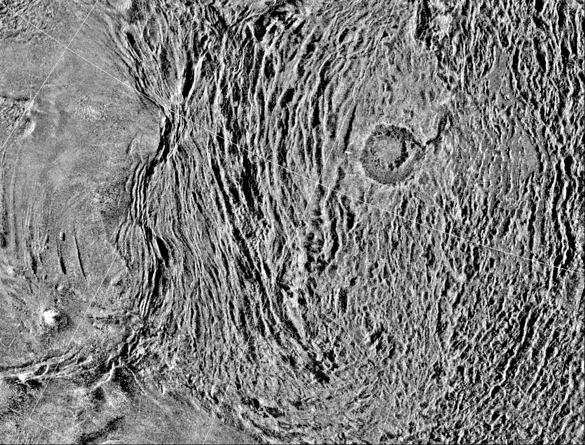
Venus keeps its surface under unbroken cloud, so in the early 1980s its geography was known only from radar, and only coarsely or in patches. From 1975 to 1977 the 300 m Arecibo dish in Puerto Rico resolved features of 10 to 20 km, but only on the hemisphere that faces Earth when the two planets are closest, according to NPO Lavochkin's 2013 history. The poles were out of reach from the ground. The American Pioneer Venus Orbiter covered 93 percent of the planet with its radar altimeter from 1978, but as a spinning craft it could resolve nothing finer than about 30 km.
The Soviet answer began at the Academy of Sciences' Institute of Radio Engineering and Electronics (IRE) in the autumn of 1972, where Yu. N. Aleksandrov, G. M. Petrov and O. N. Rzhiga developed the idea. NPO Lavochkin proposed a radar mapping satellite in December 1973, and after the Academy's president, M. V. Keldysh, received Rzhiga in November 1975, the experiment joined the national space programme, at first as a 1980 mission to map an equatorial belt at 400 to 800 m resolution. The radar went to the design bureau of the Moscow Power Engineering Institute (OKB MEI) under A. F. Bogomolov; IRE, headed by V. A. Kotelnikov, led the science and built the ground processing, with Rzhiga as scientific director. Because Arecibo had left the poles unseen, the target became the north polar region.
NPO Lavochkin built the pair, which it calls series 4V2, on the carrier bus that had delivered the landers of Venera 9 and 10 through Venera 13 and 14; Rzhiga names V. M. Kovtunenko as head of development. A pressurised ring-shaped container for the radar electronics took the place of the descent sphere. The tank block was lengthened by 1 m for orbit insertion and months of trimming, the solar panels grew by 70 percent to 7 square metres, and five extra spheres raised the attitude-control nitrogen from 36 kg to 114.2 kg, because daily imaging meant turning the whole craft on every pass. Venera 15 weighed 5,250 kg, including 2,443 kg of propellant, and Venera 16 5,300 kg, with 2,520 kg: almost a tonne more than the earlier Venus stations.
Polyus-V, as the radar was called, joined two instruments in one set. A single transmitter and receiver switched every 0.3 s between a synthetic aperture radar looking 10 degrees to the side of the ground track and an altimeter looking straight down. The transmitter was a flight-proven continuous-wave tube from the Molniya-1 communications satellite, 80 W on average, its phase flipped by a code so that echoes could be sorted by delay. The 8 cm wavelength was a compromise: shorter waves resolve more from a given antenna, but below about 10 cm the echo weakens sharply as the atmosphere of Venus absorbs it, NPO Lavochkin explains. The imaging antenna, a parabolic cylinder 6 m long and 1.4 m wide, flew folded and then opened, in Rzhiga's words, like the wings of a butterfly. NPO Lavochkin's 2013 history likens it to a watermelon rind and credits its design to the bureau, while Rzhiga names B. A. Poperechenko of OKB MEI as leader of the antenna work. Processing on Earth gave the resolving power of an antenna 70 m long.
Each 16-minute pass gathered about 3,200 bursts of echoes, stored on tape recorders that held up to 100 Mbit. To empty them before the next pass, a new 5 cm radio link carried 100 kbit/s through a 2.6 m dish, about 30 times faster than the old decimetre link. On the ground the 70 m P-2500 antenna near Yevpatoria in Crimea and OKB MEI's 64 m TNA-1500 at Medvezhi Ozera near Moscow recorded the data. Tapes from Crimea went to Moscow by courier, and the NPO Lavochkin history says the Medvezhi Ozera copies were used more often.
Three more experiments shared the ride. Omega-V, a four-channel polarisation radiometer, listened at 10 to 20 cm to the planet's own radio emission for the density, dielectric constant and temperature of the upper few metres of ground. A second transmitter let the pair sound the ionosphere and the plasma near the Sun at two frequencies. The Space Research Institute (IKI) added FS-1/4, an infrared Fourier spectrometer designed and built in the German Democratic Republic, on the reasoning that whichever craft was not mapping on a given day could use it; a German history of the country's spaceflight calls it the East German Academy's first deep space experiment. A proton counter from Moscow State University was the only science instrument at work during cruise, apart from test runs of the others.
Two faults that could have crippled the mission surfaced before launch. Astron, an astrophysical observatory built on the same design and launched on 23 March 1983, began to oscillate while holding attitude, venting nitrogen, because its added solar panels made the structure less rigid than the control model assumed. Its centimetre transmitter also came through 30 dB weaker than designed, the result of a wiring error in its antenna switch. Both Venus craft, already in final tests at the cosmodrome, shared the faults. New cables, new gas nozzles and a delay line in the attitude loop cured them; without the fix, the NPO Lavochkin history says, the orbiters would have vented all their nitrogen in their first month at Venus.
A Proton-K lifted Venera 15 from Baikonur on 2 June 1983 at 02:38:39 UT, and Venera 16 followed on 7 June. The second launch time is disputed: NPO Lavochkin gives 5 h 49 min 47.5 s Moscow time, which is 02:49:47.5 UT on the three-hour offset that matches its Venera 15 figure, while NSSDCA, Siddiqi and McDowell's GCAT catalogue give 02:32 UT. Both took a transfer arc of more than 180 degrees, longer but cheaper in propellant. In early July each radar beamed its probing signal at Earth, and the Medvezhi Ozera antenna measured it at the expected level. In September and October Venera 15 began dropping the marks of its onboard timer, which also started critical sessions such as braking and imaging, a fault that would decide its role in orbit.
After 130 days Venera 15 fired its engine for 269.6 s on 10 October 1983, braking by 1,144.5 m/s, and settled into an orbit of 904.5 by 64,687 km at 87.5 degrees. Venera 16 arrived on 14 October and needed a harder burn, 1,216.7 m/s, into 977.3 by 67,078 km. NSSDCA and Siddiqi time the insertions at 03:05 and 06:22 UT. Only shortly before braking did the team find that, through a mismatch between the ballistics specialists and the authors of the flight software, the chosen inclination did not suit the way the craft would swing its radar, so a standard pass would miss the pole itself.
Venera 15 made the first radar pass on 16 October and Venera 16 on 20 October. Venera 15's timer marks kept dropping out, so Venera 16 became the main mapper and Venera 15 its understudy, covering gaps and doing infrared and radio work in between. Corrections gave Venera 15 a working orbit of 873 by about 65,000 km, its plane turned about 4 degrees 27 minutes from its twin's, and Venera 16 one of 944 by 65,336 km, both with periods just under 24 hours and periapsis near 62 N. Venera 16 reached periapsis about three hours after Venera 15, so that their sessions would not interfere, and Venera 15 crossed the same ground three days after Venera 16, which let it fill the monthly three-day breaks for ground-station maintenance. After an unscheduled Venera 16 survey of the Metis region from 1 to 5 November, regular mapping began on 11 November 1983.
Every day for eight months the same routine followed. Near periapsis, 1,000 to 2,000 km up, the radar ran for 16 minutes, starting at 80 degrees latitude beyond the north pole, passing close to it and running roughly down a meridian to 30 N. Each pass left a strip about 7,500 km long and 120 km wide (the Soviet yearbooks printed other sizes). Venus turns 1.5 degrees beneath the orbit each day, so each strip overlapped the last. Solar gravity slowly raised the periapsis toward its 1,250 km limit, so from January 1984 the engines fired three more times on Venera 15 and twice on Venera 16, with both craft imaging before each burn so no strip was lost.
Geometry solved the pole problem. From January 1984 Venera 15 flew passes with its X axis turned 20 degrees out of the orbit plane, so that the radar swath crossed the pole; the strip came out badly curved, but only a small piece of it was needed. On 25 November 1983 Venera 15 had also imaged the area where the Venera 9 lander came down in 1975, a part of northern Beta Regio that Rzhiga later described as a system of scarps and valleys recalling rift zones on Earth.
Other troubles were small. In January 1984, as the angle between Sun and Earth seen from Venus narrowed, each craft released a spring to swing its high-gain dish 60 degrees into a new locked position, so that the solar panels could keep facing the Sun. Venera 16's dish moved cleanly; Venera 15's stopped 6 degrees short until an orbit correction on 9 April 1984 jolted it home. The only computer failure to cost a pass, on 1 April 1984, was covered by Venera 15.
By 10 March 1984, the formal end of the plan, only about half the northern hemisphere, some 60 million square kilometres, had been imaged, and with both craft healthy the mapping was extended by four months. The hardest stretch was Venus's passage behind the Sun. From early May the decimetre signal smeared and by late May it was lost in solar noise, while the 5 cm link carried telemetry as well as radar data. Both craft imaged from 10 to 13 June, then waited in Sun-pointing mode while the ground stations paused with Venus 260 million km away. NPO Lavochkin's text dates the conjunction to 15 June 1984 and its flight diagram to 16 June; the astronomy-engine library puts it at 21:59 UTC on 15 June, already 16 June in Moscow. On 17 June there was no answer. On 18 June the Yevpatoria transmitter was pushed to 80 kW, and IRE's equipment, including its signal-accumulating Kolibri apparatus, picked up a clear reply about 30 minutes later. A 450 m/s burn on 21 June swung Venera 16's orbit plane back by 18 degrees (about 20 in NSSDCA and Rzhiga), returning its track to where it had been 12 days earlier to refill the gap. Mapping ended on 10 July 1984.
Turning echoes into maps was a project of its own. IRE built a processing centre around an SM-4 minicomputer and a specialised Fourier processor that ran 50 times faster than a BESM-6 mainframe. Rzhiga credits this centre with the daily strips and height profiles; the NPO Lavochkin history assigns quick-look processing to OKB MEI and the full mosaicking to the Academy's Institute for Information Transmission Problems. Drawing the maps by hand would have taken at least ten years, so IRE and the geodesy institute TsNIIGAiK built them digitally, which Rzhiga describes as the first time every step of making a map was done by computer. The survey was cut into 27 map sheets. Orbits refined by E. L. Akim's team at the Institute of Applied Mathematics, about ten times more precise than those used in flight, removed the doubling where strips overlapped, and altimeter heights corrected perspective shifts of up to 60 km in the Maxwell mountains.
The pictures gave Venus a geology. Geologists at the Vernadsky Institute under A. T. Basilevsky analysed them from the first days and compiled a geological map of the whole survey. At Maxwell Montes the images showed the double crater Cleopatra, an outer rim 95 km across around a 55 km inner one, 1.5 km and then a further 1 km deep. To its west run parallel ridges hundreds of kilometres long, squeezed against the plateau of Lakshmi Planum, 5 to 6 km high in NPO Lavochkin's account and 2.5 to 5 km in Rzhiga's. On Lakshmi lay caldera-like basins such as Colette, 100 by 75 km, trailing radial lava flows; elsewhere the team found a lava flow 300 km long and volcanic cones that Rzhiga counts as ten times more common than on Earth. Two kinds of terrain, which Rzhiga describes as found on no other planet, received new names. Ring structures on the plains, 150 to 600 km across and called ovoids in NPO Lavochkin's account, appear in Rzhiga's 1988 book, at 200 to 600 km, named 'crown' (today's coronae), and areas of intersecting ridges, called 'parquet' by NPO Lavochkin, appear there as tessera, from the Greek for tile. From crater counts compared with the Moon, Rzhiga dates some craters to 300 to 600 million years. The Soviet accounts split on Cleopatra: NPO Lavochkin's page calls the smoothed ground around it apparently ejecta from the impact that made it, while Rzhiga wrote in 1988 that specialists had not agreed whether it was volcanic or an impact scar. Working from the Venera data in 1990, Basilevsky and Ivanov summed up the dispute: a strange caldera if volcanic, a strange crater if an impact. NASA's 1996 caption for a Magellan image calls it a double-ring impact basin about 100 km across and 2.5 km deep, and Campbell and Whitten (2022) propose that its fine-grained ejecta mantles much of Maxwell Montes.
Heights measured along each track were gridded into a topographic map, whose headline figure is the summit of Maxwell Montes, crossed by Venera 16 on 14 January 1984: 11.5 km above a sphere of 6,051 km, at 65.9 N, 2.3 E according to Rzhiga, or 66 N, 3 E in the 1985 Soviet encyclopedia yearbook. Rzhiga notes that Pioneer Venus had put the highest point 220 km further south, at 63.8 N, 2.2 E, and 11.1 km high. The altimetry table served by PDS Geosciences gives yet another figure: its highest value, 11.15 km above the same sphere (radius 6,062.15 km), appears twice, at 65.0 N, 2.5 E on the Venera 16 pass of 14 January 1984 and at 64.2 N, 4.2 E on 15 January, while samples within 5 km of Rzhiga's summit read 10.89 to 11.09 km (azmth reading of the table, 26 September 2026). No source explains the gap; the table's notes say that on most passes each measurement covered a footprint about 10 km along track and 25 to 50 km across. These heights count from 6,051 km (Rzhiga gives no reference for the Pioneer Venus figure); NSSDCA's mean radius of 6,051.8 km would lower each by 0.8 km. NASA's 1996 Magellan caption puts Maxwell almost 11 km above the mean planetary radius.
Shorter than planned, the infrared experiment still returned what NPO Lavochkin calls the first spectral measurement of the planet's heat radiation from orbit, earlier instruments having used filters. Venera 15 ran its spectrometer in 49 sessions until 14 December 1983, when the instrument lost its power supply; Venera 16 managed ten before its interferometer mirror drive broke. More than 1,500 spectra gave temperature profiles from about 60 to 90 km (65 to 90 km in the 2013 history), what the bureau calls the first recorded lines of the water vapour rotational band in the thermal spectrum of Venus, a possible sulfur dioxide band, and a latitude contrast: above 60 km, latitudes of 70 to 80 degrees were 5 to 20 K warmer than 50 degrees. Scientists were still reworking the spectra in 1999 and set them beside the Venus Express spectrometer in 2006; the wider story is in Atmosphere of Venus. Radio occultations traced the day and night ionosphere, and papers in 2009 and 2021 still drew on them. The Omega radiometer saw brightness temperatures fall from about 600 K to 400 K over Maxwell Montes, an effect American researchers, as Rzhiga reports, put down to highland rock with a very high dielectric constant, or else high electrical conductivity.
With the map finished, the pair went on to an optional programme of plasma sounding near the Sun and atmospheric occultations through October 1984. On 30 December 1984 Venera 15's attitude-control nitrogen was found to be exhausted; at the session of 5 January 1985 it was tumbling, with no charge and a nearly flat buffer battery, and on 7 January it did not answer. Venera 16 lasted until Vega 1 and 2 reached Venus. On 13 June 1985 Vega 1 lost its three-axis attitude, and controllers sent it a command to rebuild its orientation on the Sun and a star. Venera 16's command receiver worked on the same frequency and sat inside the beam of the ground antenna, so it obeyed as well and spent the last of its nitrogen in the attempt. With Vega 1 in a critical phase and Vega 2 about to arrive, the team let Venera 16 go; at the session set for 18 June it did not respond.
Both orbiters belong on the list of what we left at Venus: McDowell's GCAT catalogue, updated 24 September 2026, still lists them as circling Venus with no end date, though no observation since 1985 or orbit-lifetime study was found to confirm it. Rzhiga records that in November 1985 Mikhail Gorbachev, addressing Nobel peace laureates, set the experiment beside Sputnik, the first human spaceflight, the landing on the Moon and the landings of automatic stations on Venus and Mars, and NPO Lavochkin's 2013 anniversary article calls it the most successful uncrewed mission of the 1970s and 1980s anywhere, a claim Siddiqi reports as the journal's. Magellan, designed to resolve 120 to 300 m, later mapped 98 percent of the planet, according to Siddiqi, and PDS Geosciences still serves the Venera altimetry and radiometry tables. Mapping Venus tells the wider story of those surveys.
Mission facts
Organisations
NPO Lavochkin and the USSR Academy of Sciences (Soviet Union)
Series and serial numbers
NPO Lavochkin calls the pair its series 4V2. Siddiqi and Jonathan McDowell's GCAT catalogue give the serials as 4V-2 No. 860 (Venera 15) and No. 861 (Venera 16). COSPAR IDs 1983-053A and 1983-054A.
Venera 15: launch
2 June 1983 at 02:38:39 UT (Siddiqi; 02:38:40 in GCAT, updated 24 September 2026), Proton-K 321-01 from Site 200/39 at Baikonur. NPO Lavochkin gives 5 h 38 min 39.88 s Moscow time, three hours later on the clock.
Venera 16: launch time (disputed)
7 June 1983 on Proton-K 321-02 from Site 200/40. NSSDCA and Siddiqi give 02:32 UT and GCAT 02:32:51. NPO Lavochkin gives 5 h 49 min 47.5 s Moscow time, which on the same three-hour offset as its Venera 15 time is 02:49:47.5 UT. The sources were not reconciled.
Mass and upper stage
Venera 15: 5,250 kg including 2,443 kg of propellant; Venera 16: 5,300 kg including 2,520 kg (NPO Lavochkin; NSSDCA's summary boxes print 4,000 kg for each). NPO Lavochkin names the Blok DM, whose second firing added 3,725.6 m/s (Venera 15) and 3,695.6 m/s (Venera 16); Siddiqi calls it a Blok D-1, 11S824M Nos. 8L and 9L.
Changes from earlier Venera orbiters
Descent craft replaced by a pressurised toroidal container for the radar; tank block lengthened by 1 m; solar panels enlarged 70 percent to 7 square metres; attitude nitrogen raised from 36 kg to 114.2 kg with five extra spheres (NPO Lavochkin, 2013).
Radar (Polyus-V)
8 cm synthetic aperture radar and radio altimeter sharing one transmitter and receiver, switching every 0.3 s. Continuous-wave travelling-wave tube from the Molniya-1 satellite, 80 W; phase-coded pulses of 1.54 microseconds; 6 by 1.4 m imaging antenna looking 10 degrees off vertical; 1 m altimeter dish (Rzhiga). Mass 298.6 kg (NPO Lavochkin).
Other instruments
Omega-V four-channel polarisation radiometer (10 to 20 cm; 22.95 kg per NPO Lavochkin); FS-1/4 infrared Fourier spectrometer, designed and built in the German Democratic Republic and added at IKI's proposal; two-frequency radio occultation; KS-18-6V proton detector from Moscow State University's nuclear physics institute.
Venera 15: orbit insertion
10 October 1983 after 130 days: 269.6 s burn, 1,144.5 m/s, 1,667.67 kg of propellant, into 904.5 by 64,687 km at 87.5 degrees, period 23 h 26 min 49.6 s (NPO Lavochkin). NSSDCA and Siddiqi time it at 03:05 UT.
Venera 16: orbit insertion
14 October 1983 after 129 days: 1,216.7 m/s using 1,754.3 kg, into 977.3 by 67,078 km, period 24 h 34 min 16.8 s (NPO Lavochkin). NSSDCA and Siddiqi time it at 06:22 UT.
Working orbits
Venera 15: 873 by about 65,000 km, 23 h 57 min 26 s, after corrections on 17 October and 2 November 1983. Venera 16: 944 by 65,336 km, 23 h 57 min 51 s, after one correction on 22 October. Periapsis near 62 N; planes about 4 degrees 27 minutes apart. Inclination is 87.5 degrees in NPO Lavochkin's texts and 92.5 degrees to the equator in Rzhiga's; the two add up to 180.
Imaging pass
16 minutes near periapsis from heights of 1,000 to 2,000 km, from 80 degrees beyond the pole to 30 N. Strip about 7,500 by 120 km (NPO Lavochkin, Rzhiga, NSSDCA); 7,000 by 100 km (Soviet encyclopedia yearbook 1984); about 8,000 by 160 km (yearbook 1985). The plan was about 9,000 by 70 to 100 km in NPO Lavochkin's 2013 history and 7,000 to 8,000 km long on its project page.
Coverage and resolution
115 million square km, 25 percent of Venus, from the pole to about 30 N (NPO Lavochkin, Rzhiga); Mitchell writes about 25 degrees, and the archived altimetry table reaches 22.9 N. Resolution 0.9 to 2.5 km depending on height; 3 to 4 km in the quick images made from onboard data (yearbook 1985).
Start of mapping (sources differ)
First radar passes 16 October (Venera 15) and 20 October 1983 (Venera 16); unscheduled Venera 16 survey of the Metis region 1 to 5 November; regular mapping from 11 November (NPO Lavochkin). NSSDCA's radar page instead says the first Venera 15 images came on 11 November and the mapping sequence began on 23 November, the date the Venera 15 passes begin in the archived altimetry table.
Data link and ground stations
New 5 cm link at 100 kbit/s through a 2.6 m two-position dish, about 30 times faster than the decimetre link; up to 100 Mbit a day. Received by the 70 m P-2500 near Yevpatoria and OKB MEI's 64 m TNA-1500 at Medvezhi Ozera near Moscow.
Highest point measured
11.5 km above a 6,051 km sphere, recorded by Venera 16 on 14 January 1984, at 65.9 N, 2.3 E (Rzhiga) or 66 N, 3 E (yearbook 1985). Rzhiga cites Pioneer Venus at 11.1 km, 63.8 N, 2.2 E. The archived altimetry table peaks at 6,062.15 km (11.15 km) twice, at 65.0 N, 2.5 E on 14 January and 64.2 N, 4.2 E on 15 January 1984, and reads 6,061.89 to 6,062.09 km within 5 km of Rzhiga's summit position (azmth reading of the table, 26 September 2026).
Infrared spectrometer
49 sessions on Venera 15 to 14 December 1983, 10 on Venera 16; more than 1,500 spectra at about 280 to 1,600 per cm, resolution 5 or 7.5 per cm, footprint about 60 km (NPO Lavochkin). NSSDCA lists 250 to 1,600 per cm for Venera 15 and 400 to 1,600 for Venera 16; principal investigator V. I. Moroz.
Maps and atlas
27 map sheets, built entirely by computer at IRE with TsNIIGAiK (Rzhiga). IRE's history (Gulyaev, 2018) dates the Atlas of the Surface of Venus, chief editor V. A. Kotelnikov, to 1989 (Moscow, MIIGAiK). Siddiqi describes an 'Atlas of Venus' album published in 1988 by the Main Directorate of Geodesy and Cartography and does not say whether it is the same work.
Venera 15: end
Nitrogen exhausted 30 December 1984; found tumbling with no charge and a nearly empty buffer battery on 5 January 1985; no answer on 7 January (NPO Lavochkin). NSSDCA and Siddiqi date last contact to 5 January 1985.
Venera 16: end
On 13 June 1985 a command sent to Vega 1 also reached Venera 16, which shared its command receiver frequency; it used its last nitrogen trying to reorient and did not answer at the session set for 18 June (NPO Lavochkin).
Present state (as of 26 September 2026)
McDowell's GCAT Lunar and Planetary Register, updated 24 September 2026, gives both orbiters status O, which GCAT defines as still in orbit, with no end date: Venera 15 at 1,000 by 65,000 km and 87.5 degrees, Venera 16 at 1,000 by 60,000 km and 87.0 degrees (elements of October 1983). No observation since 1985 or orbit-lifetime study was found.
Mission timeline
- 1972 to 1975The idea of a radar mapping satellite arises at IRE in autumn 1972; NPO Lavochkin proposes one in December 1973; the Venus programme approved in late 1975 plans an equatorial map from a 1980 launch.
- 23 Mar 1983Astron, built on the same bus, is launched; in its first days it shows attitude oscillations, and a wiring error in the antenna switch of its centimetre transmitter follows. Both Venus craft share the faults and are fixed at the launch site.
- 2 Jun 1983Venera 15 lifts off from Baikonur on a Proton-K at 02:38:39 UT.
- 7 Jun 1983Venera 16 follows; the launch time is 02:32 UT in NSSDCA and Siddiqi and 02:49:47.5 UT by NPO Lavochkin's Moscow time.
- 2 to 7 Jul 1983In cruise, each radar beams its probing signal at Earth and the Medvezhi Ozera antenna confirms the expected level.
- 10 Oct 1983Venera 15 brakes into orbit around Venus: 904.5 by 64,687 km, 87.5 degrees.
- 14 Oct 1983Venera 16 enters orbit: 977.3 by 67,078 km.
- 16 and 20 Oct 1983First radar passes by Venera 15 and then Venera 16.
- 11 Nov 1983Regular mapping begins, with Venera 16 as the main mapper and Venera 15 as its backup.
- 14 Dec 1983Venera 15's infrared spectrometer completes its 49th and last measuring session before losing power; ten later sessions on Venera 16 end when its mirror drive fails.
- 14 Jan 1984Venera 16's altimeter crosses the summit of Maxwell Montes, 11.5 km above the 6,051 km reference sphere in Soviet accounts.
- 10 Mar 1984The planned programme formally ends with about half the northern hemisphere mapped; mapping is extended by four months.
- 15 to 18 Jun 1984Venus passes behind the Sun at 260 million km; after a pause, contact is regained on 18 June with an 80 kW uplink.
- 21 Jun 1984A 450 m/s burn turns Venera 16's orbit plane back 18 degrees to refill the gap left by the conjunction.
- 10 Jul 1984Mapping of the north from the pole to 30 N is complete: 115 million square km.
- 5 to 7 Jan 1985Venera 15, out of nitrogen since 30 December, is found tumbling on 5 January and does not answer on 7 January.
- 13 to 18 Jun 1985A command meant for Vega 1 sets Venera 16 hunting for a star; it spends its last nitrogen and misses the session of 18 June.
- 1988 to 1989IRE's history dates the Atlas of the Surface of Venus, edited by V. A. Kotelnikov, to 1989; Siddiqi dates an 'Atlas of Venus' album from the Main Directorate of Geodesy and Cartography to 1988.
A filled dot marks something that physically happened. A hollow one marks an announcement, a naming or a target.
In pictures
Tap a photo to enlarge.
Translated from the original sources
Passages from the Russian and German sources this page draws on, in azmth's translation. Tap Show original to read the original wording.
NPO Lavochkin, project page Venera-15, Venera-16
Russian · 18 passages
“On 10 October 1983, 130 days after launch, the engine was started and, after running for 269.6 seconds, put the Venera-15 spacecraft into orbit as an artificial satellite of Venus with these parameters: pericentre height 904.5 km, apocentre 64,687 km, inclination 87.5 degrees, period 23 hours 26 minutes 49.6 seconds.”
azmth's translation · Show originalHide original
Russian: «10 октября 1983 года, спустя 130 суток после старта, включен двигатель, который, проработав 269,6 секунды, обеспечил выход КА «Венера-15» на орбиту искусственного спутника Венеры со следующими параметрами: высота в перицентре 904,5 км, в апоцентре 64687 км, наклонение 87,5°, период обращения 23 часа 26 минут 49,6 секунды.»
“129 days after launch, on 14 October 1983, the Venera-16 spacecraft entered orbit as an artificial satellite of the planet.”
azmth's translation · Show originalHide original
Russian: «Спустя 129 суток после старта, 14 октября 1983 года КА «Венера-16» вышел на орбиту искусственного спутника планеты.»
“It should be noted that, because of a lack of coordination between the ballistics specialists and the developers of the software for the control system's onboard computer, an orbital inclination was chosen that did not suit the direction of the spacecraft's programmed swing during the imaging session.”
azmth's translation · Show originalHide original
Russian: «Следует отметить, что из-за несогласованности баллистиков и разработчиков программного обеспечения БЦВМ САУ было выбрано наклонение орбиты, не адекватное направлению программного склонения КА в сеансе съемки.»
“In particular, Venera-15 made it possible to close the blank spot on the map”
azmth's translation · Show originalHide original
Russian: «В частности с помощью «Венеры-15» удалось закрыть белое пятно на карте»
“In addition, on 25 November 1983 Venera-15 imaged the landing area of the Venera-9 station.”
azmth's translation · Show originalHide original
Russian: «Кроме того, 25 ноября 1983 года «Венера-15» провела съемку района посадки станции «Венера-9».»
“On the basis of the payload checkout runs and the state of the onboard equipment, Venera-16 was chosen as the main spacecraft for mapping Venus and given the leading role in the mapping.”
azmth's translation · Show originalHide original
Russian: «Исходя из результатов проверочных включений полезной нагрузки и состояния бортовой аппаратуры, основным аппаратом для картографирования Венеры выбрана «Венера-16», которой была отведена главная роль по проведению картографирования Венеры.»
“With the planet turning 1.5 degrees a day relative to the orbit plane, Venera-15 passed over the same areas of the planet three days later than Venera-16.”
azmth's translation · Show originalHide original
Russian: «При суточном вращении планеты относительно плоскости орбиты 1,5° «Венера-15» на трое суток позже «Венеры-16» проходила над теми же районами планеты.»
“Formally, the planned imaging programme was completed on 10 March 1984.”
azmth's translation · Show originalHide original
Russian: «Формально запланированная программа съемки была завершена 10 марта 1984 года.»
“Therefore, on 21 June 1984 a trajectory correction of Venera-16 was made, with which the orbit plane was turned back by 18 degrees”
azmth's translation · Show originalHide original
Russian: «Поэтому 21 июня 1984 года проведена коррекция траектории полета «Венеры-16», с помощью которой плоскость орбиты развернули назад на 18°»
“This point was recorded by the profiler of the Venera-16 spacecraft on 14 January 1984.”
azmth's translation · Show originalHide original
Russian: «Эта точка была зафиксирована профилографом аппарата «Венера-16» 14 января 1984 года.»
“A specific type of Venusian terrain, called 'parquet', was also discovered, along with much else that was unexpected and interesting.”
azmth's translation · Show originalHide original
Russian: «Обнаружен также специфический тип венерианской местности, названный «паркет», и еще много неожиданного и интересного.»
“For the first time, lines of the H2O rotational band, lying in the 280 to 475 per cm region, were recorded in the thermal emission spectrum of Venus.”
azmth's translation · Show originalHide original
Russian: «Впервые в спектре теплового излучения Венеры были зафиксированы линии вращательной полосы Н2О, расположенные в области 280-475 см -1.»
“On 30 December complete exhaustion of the working fluid (nitrogen) of the attitude control system was recorded on Venera-15.”
azmth's translation · Show originalHide original
Russian: «30 декабря на «Венере-15» зафиксировано полное израсходование рабочего тела (азота) системы ориентации.»
“Because the working frequencies of the command receivers coincided, the star-search mode also switched on at the same time on Venera-16, which happened to be within the beam of the ground transmitting antenna.”
azmth's translation · Show originalHide original
Russian: «Из-за совпадения рабочих частот командных приемников одновременно включился режим поиска звезды и на «Венере-16», которая оказалась в пределах диаграммы направленности наземной передающей антенны.»
“A communication session with the Venera-16 spacecraft was scheduled for 18 June, but the craft did not come on the line.”
azmth's translation · Show originalHide original
Russian: «Сеанс связи с КА «Венера-16» был назначен на 18 июня, однако аппарат на связь не вышел.»
“On the other hand, at wavelengths shorter than 10 cm the power of the reflected signals drops sharply because the electromagnetic radiation is absorbed in the atmosphere of Venus, through which the radio waves probing the surface pass.”
azmth's translation · Show originalHide original
Russian: «С другой стороны, на длинах волн короче 10 см резко падает мощность отраженных сигналов вследствие поглощения электромагнитного излучения в атмосфере Венеры, через которую проходят радиоволны, зондирующие поверхность.»
“Immediately around the crater the relief is smoothed, apparently by material thrown out by the impact of the meteorite that formed the crater, and looks brighter.”
azmth's translation · Show originalHide original
Russian: «Непосредственно вокруг кратера рельеф сглажен, по-видимому, выбросом при ударе метеорита, образовавшего кратер, и выглядит более светлым.»
“With a spectral instrument, the planet's thermal emission was measured from the orbit of an artificial satellite for the first time. Earlier, the Soviet Venera 9 and 10 and the American Pioneer Venus used instruments with filters.”
azmth's translation · Show originalHide original
Russian: «С помощью спектрального прибора впервые с орбиты искусственного спутника измерено тепловое излучение планеты. Ранее на советских аппаратах «Венера-9,10» и американском «Пионер-Венера» использовались приборы с фильтрами.»
V. A. Molodtsov, Mapping of Venus: 30 years since the launch of Venera-15 and Venera-16, Vestnik NPO im. S. A. Lavochkina, 2013, no. 2
Russian · 9 passages
“The idea of the experiment arose at the Institute of Radio Engineering and Electronics of the USSR Academy of Sciences in the autumn of 1972.”
azmth's translation · Show originalHide original
Russian: «Идея эксперимента возникла в ИРЭ АН СССР осенью 1972 года.»
“Outwardly the side-looking radar antenna resembled a watermelon rind.”
azmth's translation · Show originalHide original
Russian: «Внешне антенна РЛБО напоминала арбузную корку.»
“the nitrogen supply of the attitude control actuators was increased from 36 kg to 114.2 kg by fitting five additional spherical nitrogen bottles.”
azmth's translation · Show originalHide original
Russian: «запас азота в системе исполнительных органов системы ориентации был увеличен с 36 кг до 114,2 кг за счет установки 5 дополнительных шаробаллонов с азотом.»
“This instrument, designed and manufactured in the German Democratic Republic, made it possible to obtain data on the chemical composition and physical characteristics of the atmosphere of Venus.”
azmth's translation · Show originalHide original
Russian: «Этот прибор, разработанный и изготовленный в Германской Демократической Республике, позволял получать данные о химическом составе и физических характеристиках атмосферы Венеры.»
“Otherwise the stations would have vented all their nitrogen in the first month of work in orbit.”
azmth's translation · Show originalHide original
Russian: «В противном случае АМС стравили бы весь азот в первый месяц работы на орбите.»
“About 30 minutes after the command to start the communication session was sent, it was IRE's equipment that recorded a clear signal from the interplanetary station.”
azmth's translation · Show originalHide original
Russian: «Спустя ~30 минут после выдачи команды на включение сеанса связи именно на средствах ИРЭ был зафиксирован четкий сигнал с межпланетной станции.»
“The mission of the Venera-15 and Venera-16 stations became the most successful in the history of uncrewed spaceflight of the 1970s and 1980s, not only in our country but in the world.”
azmth's translation · Show originalHide original
Russian: «Миссия АМС «Венера-15» и «Венера-16» стала наиболее успешной в истории непилотируемой космонавтики 70-80-х годов, не только отечественной, но и мировой.»
“In addition, equipment of the IRE laboratory was brought in, including the Kolibri apparatus, which can accumulate the signal.”
azmth's translation · Show originalHide original
Russian: «Кроме того, были привлечены средства лаборатории ИРЭ, в том числе аппаратура «Колибри», позволяющая накапливать сигнал.»
“From spectra of the thermal emission of Venus at wavelengths of 5 to 30 micrometres it was possible to determine the vertical temperature profile at the little-studied heights of 65 to 90 km above the planet's surface.”
azmth's translation · Show originalHide original
Russian: «По спектрам теплового излучения Венеры в диапазоне волн 5-30 мкм удалось определить вертикальный профиль температуры на малоисследованных высотах от 65 до 90 км над поверхностью планеты.»
O. N. Rzhiga, A New Era in the Study of Venus
Russian · 2 passages
O. N. Rzhiga, A New Era in the Study of Venus (Znanie, Moscow, 1988), chapter on the radar system
Open the source“a continuous-wave transmitter proven in spaceflight, taken from the Molniya-1 communications satellite and built around a travelling-wave tube with an average power of 80 W, was used.”
azmth's translation · Show originalHide original
Russian: «применен проверенный в условиях космического полета передатчик непрерывного излучения от спутника связи «Молния-1» на лампе бегущей волны со средней мощностью 80 Вт.»
“B. A. Poperechenko led the development of the antennas at OKB MEI.”
azmth's translation · Show originalHide original
Russian: «Руководил разработкой антенн в ОКБ МЭИ Б.А. Попереченко.»
O. N. Rzhiga
Russian · 1 passage
O. N. Rzhiga (1988), chapter on the spacecraft
Open the source“During launch from Earth and injection onto the path to Venus the reflector of this antenna lay folded under a protective fairing, and after the fairing was jettisoned it opened like the wings of a butterfly.”
azmth's translation · Show originalHide original
Russian: «При старте, с Земли и выводе на трассу перелета к Венере зеркало этой антенны находилось под защитным обтекателем в сложенном положении, а после его сброса раскрылось, как крылья у бабочки.»
O. N. Rzhiga
Russian · 1 passage
O. N. Rzhiga (1988), chapter on the orbits
Open the source“The inclination of the orbital plane to the equator of Venus is 92.5 degrees.”
azmth's translation · Show originalHide original
Russian: «Наклонение плоскости орбиты к экватору Венеры 92,5°.»
O. N. Rzhiga
Russian · 3 passages
O. N. Rzhiga (1988), chapter on the structure of Ishtar Terra
Open the source“In the northern part of the oval, 200 km west of the centre of Cleopatra crater (longitude 2.3 degrees, latitude 65.9 degrees), lies the highest point, 11.5 km.”
azmth's translation · Show originalHide original
Russian: «В северной части овала в 200 км к западу от центра кратера Клеопатры (долгота 2,3°, широта 65,9°) находится наивысшая точка 11,5 км*.»
“(For comparison, according to the radio altimeter of the Pioneer Venus spacecraft, the highest point of Maxwell Montes lies 220 km further south (longitude 2.2 degrees, latitude 63.8 degrees) and has a height of 11.1 km.)”
azmth's translation · Show originalHide original
Russian: «(* Для сравнения укажем, что, по данным радиовысотомера космического аппарата «Пионер-Венера», наивысшая точка Гор Максвелла находится на 220 км южнее (долгота 2,2°, широта 63,8°) и имеет выcоту 11,1 км.)»
“The high plateau of Lakshmi Planum, about 1,500 km from north to south and 2,000 km from west to east, has a height of 2.5 to 5 km.”
azmth's translation · Show originalHide original
Russian: «Высокогорное Плато Лакшми протяженностью около 1500 км с севера на юг и 2000 км с запада на восток имеет высоту от 2,5 до 5 км.»
O. N. Rzhiga
Russian · 3 passages
O. N. Rzhiga (1988), chapter on geology
Open the source“These zones, which have a distinctive surface pattern and are not found on other planets, received the name 'tessera' ('tile' from the Greek).”
azmth's translation · Show originalHide original
Russian: «Эти зоны, имеющие специфический рисунок поверхности и не встречающиеся на других планетах, получили наименование «Тессера» («черепица» с греческого).»
“These formations, not found on other planets, received the name 'venets' (crown).”
azmth's translation · Show originalHide original
Russian: «Эти образования, невстречающиеся на других планетах, получили наименование «Венец».»
“On the plains west and east of Ishtar Terra unusual ring formations 200 km to 600 km across were found.”
azmth's translation · Show originalHide original
Russian: «На равнинах к западу и востоку от Земли Иштар обнаружены необычные кольцевые образования поперечником от 200 км до 600 км.»
O. N. Rzhiga
Russian · 1 passage
O. N. Rzhiga (1988), conclusion
Open the source“this experiment was placed on a par with the launch of the first satellite, the first human flight into space, the landing on the Moon, and the landings of automatic stations on Venus and Mars.”
azmth's translation · Show originalHide original
Russian: «этот эксперимент поставлен в один ряд с запуском первого спутника, первым полетом человека в космос и высадкой на Луну, посадкой автоматических станций на Венеру и Марс.»
O. N. Rzhiga
Russian · 2 passages
O. N. Rzhiga (1988), chapter on making the photomaps and topographic maps
Open the source“drawing the maps by hand with relief shading would have taken at least 10 years.”
azmth's translation · Show originalHide original
Russian: «при рисовании карт вручную с отмывкой рельефа потребовалось бы не менее 10 лет.»
“For the first time, every operation in making the map, including synthesising the radar images and surface height profiles of Venus from the reflected signal, recasting them into a set map projection, removing perspective distortions, and adding the coordinate grid, contour lines and lettering, was done entirely by digital methods.”
azmth's translation · Show originalHide original
Russian: «Впервые все операции по созданию карты, включая синтез радиолокационных изображений и профилей высот поверхности Венеры по отраженному сигналу, перестроение их в определенную картографическую проекцию, устранение перспективных искажений, нанесение координатной сетки, горизонталей и надписей целиком выполнены цифровыми методами.»
Epizody kosmonavtiki, Venera-16
Russian · 1 passage
Epizody kosmonavtiki, Venera-16 (Soviet encyclopedia yearbook 1985), Wayback copy
Open the source“Roughly in the middle of this oval, 200 km west of Cleopatra Patera (longitude 3 degrees, latitude 66 degrees), lies a point 11.5 km high.”
azmth's translation · Show originalHide original
Russian: «Примерно в середине этого овала в 200 км к западу от Патеры Клеопатра (долгота 3°, широта 66°) находится точка высотой 11,5 км.»
Epizody kosmonavtiki, Venera-15
Russian · 1 passage
Epizody kosmonavtiki, Venera-15 (Soviet encyclopedia yearbooks 1984 and 1985), Wayback copy
Open the source“To study the planet's atmosphere, the Venera-15 and Venera-16 stations carry infrared Fourier spectrometers created jointly by specialists of the USSR and the GDR and manufactured in the GDR.”
azmth's translation · Show originalHide original
Russian: «Для изучения атмосферы планеты на борту АМС «Венера-15», «Венера-16» установлены инфракрасные фурье-спектрометры, созданные совместно специалистами СССР и ГДР и изготовленные в ГДР.»
Yu. V. Gulyaev, The Kotelnikov Institute of Radio Engineering and Electronics at 65, RENSIT 2018
Russian · 1 passage
Yu. V. Gulyaev, The Kotelnikov Institute of Radio Engineering and Electronics at 65, RENSIT 2018 (CyberLeninka)
Open the source“As a result of the analysis of these unique data the first Atlas of the Surface of Venus in the history of science was created and later published (Moscow, MIIGAiK, 1989), chief editor”
azmth's translation · Show originalHide original
Russian: «В результате анализа этих уникальных данных был создан и впоследствии опубликован первый в истории науки "Атлас поверхности Венеры" (М., МИИГАиК, 1989), главный редактор»
NPO Lavochkin, A day in history: 35 years of the first Venus cartographers
Russian · 1 passage
NPO Lavochkin, A day in history: 35 years of the first Venus cartographers (2018)
Open the source“The project was judged a success: for the first time, radar images were obtained of the north polar region of Venus, unstudied until then.”
azmth's translation · Show originalHide original
Russian: «Проект был признан удачным, впервые были получены радиолокационные изображения неизученной до того времени северной приполярной области Венеры.»
NPO Lavochkin, 40 years since the launch of Venera-15 and Venera-16
Russian · 1 passage
NPO Lavochkin, 40 years since the launch of Venera-15 and Venera-16 (2023)
Open the source“Both interplanetary stations were a modification of the previous Venus spacecraft”
azmth's translation · Show originalHide original
Russian: «Обе межпланетные станции были модификацией предыдущих венерианских аппаратов»
Funkzentrum in Media, Hammer und Zirkel im All: history of East German spaceflight
German · 2 passages
Funkzentrum in Media, Hammer und Zirkel im All: history of East German spaceflight (2009)
Open the source“For its first deep space experiment the Academy developed an infrared Fourier spectrometer that was used in 1983 on the Soviet probes Venera 15 and 16.”
azmth's translation · Show originalHide original
German: „Für das erste Tiefraumexperiment entwickelte die Akademie ein Infrarot-Fourier-Spektrometer, das 1983 auf den sowjetischen Sonden Venera 15 und 16 eingesetzt wurde.“
“The Institute for Space Research (IKF), the Central Institute for Optics and Spectroscopy (ZOS) and the Centre for Scientific Instrument Building (ZWG) subsequently developed a further infrared Fourier spectrometer: FS 1/4.”
azmth's translation · Show originalHide original
German: „Das Institut für Kosmosforschung (IKF), das Zentralinstitut für Optik und Spektroskopie (ZOS) sowie das Zentrum für den wissenschaftlichen Gerätebau (ZWG) entwickelten im Folgenden ein weiteres Infrarot-Fourier-Spektrometer: FS 1/4.“
O. N. Rzhiga
Russian · 1 passage
O. N. Rzhiga (1988), chapter on transmitting the radar data to Earth
Open the source“Compared with the earlier decimetre-band deep space radio link, the data rate rose 30 times.”
azmth's translation · Show originalHide original
Russian: «По сравнению с прежней радиолинией дальней космической связи дециметрового диапазона длин волн скорость передачи информации возросла в 30 раз.»
O. N. Rzhiga
Russian · 1 passage
O. N. Rzhiga (1988), chapter on the radar data processing centre
Open the source“With this device the Fourier transform is performed 50 times faster than, say, on the large general-purpose BESM-6 computer.”
azmth's translation · Show originalHide original
Russian: «С помощью этого устройства преобразование Фурье выполняется в 50 раз быстрее, чем, скажем, на большой универсальной ЭВМ БЭСМ-6.»
O. N. Rzhiga
Russian · 1 passage
O. N. Rzhiga (1988), chapter on some results of the radar survey
Open the source“It was recorded by the Venera-16 spacecraft on 14 January 1984 (fig. 20).”
azmth's translation · Show originalHide original
Russian: «Она была зафиксирована космическим аппаратом «Венера-16» 14 января 1984 г. (рис. 20).»
O. N. Rzhiga
Russian · 1 passage
O. N. Rzhiga (1988), chapter 'Planet of riddles' (radiometry, open questions)
Open the source“Over Maxwell Montes and other elevated regions the radio brightness temperature was seen to fall to 400 K, whereas the average for Venus is 600 K (see fig. 7).”
azmth's translation · Show originalHide original
Russian: «При прохождении Гор Максвелла и других возвышенных областей наблюдалось понижение радиояркостной температуры до 400 К, в то время как в средлем для Венеры она составляет 600 К (см. рис. 7).»
Sources
- NPO Lavochkin, project page Venera-15, Venera-16 · in Russian
- V. A. Molodtsov, Mapping of Venus: 30 years since the launch of Venera-15 and Venera-16, Vestnik NPO im. S. A. Lavochkina, 2013, no. 2 · in Russian
- NPO Lavochkin, 40 years since the launch of Venera-15 and Venera-16 (2023) · in Russian
- NPO Lavochkin, A day in history: 35 years of the first Venus cartographers (2018) · in Russian
- O. N. Rzhiga, A New Era in the Study of Venus (Znanie, Moscow, 1988), chapter on the radar system · in Russian
- O. N. Rzhiga (1988), chapter on the spacecraft · in Russian
- O. N. Rzhiga (1988), chapter on the orbits · in Russian
- O. N. Rzhiga (1988), chapter on the structure of Ishtar Terra · in Russian
- O. N. Rzhiga (1988), chapter on geology · in Russian
- Epizody kosmonavtiki, Venera-15 (Soviet encyclopedia yearbooks 1984 and 1985), Wayback copy · in Russian
- Epizody kosmonavtiki, Venera-16 (Soviet encyclopedia yearbook 1985), Wayback copy · in Russian
- Yu. V. Gulyaev, The Kotelnikov Institute of Radio Engineering and Electronics at 65, RENSIT 2018 (CyberLeninka) · in Russian
- Funkzentrum in Media, Hammer und Zirkel im All: history of East German spaceflight (2009) · in German
- NSSDCA, Venera 15 (Wayback copy)
- NSSDCA, Venera 16 (Wayback copy)
- NSSDCA, Venera 15 synthetic aperture radar
- NSSDCA, Venera 15 infrared Fourier spectrometer
- NSSDCA, Venera 16 radio occultation
- Asif Siddiqi, Beyond Earth: A Chronicle of Deep Space Exploration, 1958 to 2016 (NASA, 2018), entries 164 and 165
- Jonathan McDowell, GCAT launch list (updated 24 September 2026)
- PDS Geosciences Node, Venera data page
- PDS Geosciences, Venera altimetry description
- Don P. Mitchell, Catalog of Soviet Venus images
- NSSDCA, Venus fact sheet
- Zasova et al., Exploration of Venus with the Venera-15 IR Fourier spectrometer and the Venus Express planetary Fourier spectrometer, Cosmic Research 44 (2006)
- L. V. Zasova et al., Structure of the Venus middle atmosphere: Venera 15 Fourier spectrometry data revisited, Advances in Space Research (1999)
- O. N. Rzhiga (1988), chapter on transmitting the radar data to Earth · in Russian
- O. N. Rzhiga (1988), chapter on the radar data processing centre · in Russian
- O. N. Rzhiga (1988), chapter on some results of the radar survey · in Russian
- O. N. Rzhiga (1988), chapter on making the photomaps and topographic maps · in Russian
- O. N. Rzhiga (1988), chapter 'Planet of riddles' (radiometry, open questions) · in Russian
- O. N. Rzhiga (1988), chapter 'A little history' · in Russian
- O. N. Rzhiga (1988), conclusion · in Russian
- NSSDCA, Venera 16 infrared Fourier spectrometer (Wayback copy)
- NASA Photojournal, PIA00149: Venus, Maxwell Montes and Cleopatra Crater (Magellan, 1996)
- Jonathan McDowell, GCAT Lunar and Planetary Register, lprcat (updated 24 September 2026)
- Jonathan McDowell, GCAT definitions: Phases and Status values
- Basilevsky and Ivanov, Cleopatra Crater on Venus: Venera 15/16 data and impact/volcanic origin controversy, Geophysical Research Letters 17 (1990), 175-178
- Campbell and Whitten, Crater Ejecta Across Maxwell Montes, Venus, and Possible Effects on Future Rock Type Measurements, Geophysical Research Letters 49 (2022)
- Don P. Mitchell, About Copyright (terms for his Venera 15 and 16 images)
- JPL Horizons Lookup API, query 'Venera'
Facts on this page were verified on 26 September 2026. Where sources disagree, the disagreement is stated rather than resolved silently.
azmth is independent and is not affiliated with or endorsed by NASA, Roscosmos, NPO Lavochkin, ESA, JAXA, ISRO, CNSA, or any other space agency or company named on this page.