Mapping Venus
How radar mapped Venus through the clouds from 1961 to Magellan, why nearly all its 1,985 names honour women and goddesses, and why Skadi Mons was dropped.
TL;DR· 19 min read
Radar made the map of Venus, because clouds hide its surface from ordinary telescopes. Between 1961 and 1967, radar on Earth pinned down the distance from Earth to the Sun, showed that Venus spins slowly backwards and found the first surface features; Pioneer Venus, Venera 15 and 16 and Magellan then mapped almost the whole planet from orbit. The IAU's 1,985 names honour women and goddesses, apart from Maxwell, Alpha, Beta and the long valleys, which carry words for the planet itself. Zero longitude runs through the crater Ariadne, and the name Skadi Mons was dropped on 17 December 2025 because the mountain is not there.
How was the surface of Venus mapped?
Venus was mapped by radar, because its thick clouds hide the surface from ordinary telescopes. Radar dishes on Earth picked out its first surface features in the 1960s, and three orbital missions then mapped it from above: Pioneer Venus Orbiter measured heights from 1978, Venera 15 and 16 imaged the north in 1983 and 1984, and Magellan covered more than 98 percent of the planet between 1990 and 1992. Echoes caught in 1961 also fixed the scale of the solar system, and by 1963 radar had shown that Venus spins slowly backwards. The International Astronomical Union named what the maps showed almost entirely after women and goddesses, with three exceptions (Maxwell Montes, Alpha Regio and Beta Regio), while the longest valleys carry the word for Venus in dozens of languages.
- 1,985IAU-approved feature names on Venus, in the gazetteer file dated 3 November 2026
- 3exceptions written into the IAU's Venus theme table: one physicist (Maxwell) and two Greek letters (Alpha and Beta)
- 98 %of the surface imaged by Magellan's radar at about 100 m resolution, the basis of today's maps
Oleg Rzhiga of the Soviet Institute of Radio Engineering and Electronics (IRE) explained in 1988 why Venus had to be mapped by radar: in visible, infrared and ultraviolet light an observer sees the cloud tops 65 to 70 km up, while radio waves pass through the atmosphere and reflect from the solid surface. Telescope observers drew markings all the same. Francesco Bianchini's Hesperi et Phosphori nova phaenomena of 1728 showed dusky patches on the partly lit disc, markings that the Linda Hall Library calls illusory (the imagined Venus page follows that thread). The real map began with radar echoes in 1961 and was completed from orbit by Pioneer Venus Orbiter, Venera 15 and 16 and Magellan.
It opened with a wrong answer. MIT's Lincoln Laboratory announced radar echoes from Venus in 1958, and Jodrell Bank said in September 1959 that it had validated them; both implied an astronomical unit, the mean distance from Earth to the Sun, of 149,467,000 km, and Lincoln could not repeat its own result. JPL pointed its Goldstone radars at Venus on 10 March 1961, and that July W. K. Victor and R. Stevens announced in Science a value of 149,599,000 km, give or take 1,500 km, more than 100,000 km larger. Andrew Butrica's NASA history of planetary radar, To See the Unseen, calls this the first unambiguous detection, while noting that Lincoln later found an echo of 6 March 1961 on its own tapes; Lincoln, Jodrell Bank and an RCA group all published 1961 values within a few thousand kilometres of JPL's. MIT's obituary of Gordon Pettengill, who aimed Lincoln's Millstone radar at Venus in 1961, says the recalibrated unit proved instrumental in navigating Mariner 2 in 1962.
Vladimir Kotelnikov, IRE's director, led the Soviet attempt from the deep space communications centre near Yevpatoria in Crimea, using, Rzhiga wrote, the centre's transmitting antenna built to command spacecraft. The team observed Venus from 18 to 26 April 1961, and on 12 May Pravda and Izvestia printed a preliminary astronomical unit that Butrica gives as 149,457,000 km. IRE's full analysis, published in Radiotekhnika i elektronika in 1962, gave 149,599,300 km with a maximum error of 2,000 km, and a footnote explained the slip: the first reports had resolved an ambiguity with older astronomical values that had proved wrong, 'therefore the value of the astronomical unit given in the newspapers is also wrong'.
Radar also showed how Venus turns. The Soviet 1962 paper found a narrow spike in the echo plus a broad component up to 400 Hz wide, and offered two readings: a day of about 11 Earth days if the broad part came from the whole rotating surface, or more than 100 days if Venus scattered like the Moon and the broad part came from something else. Butrica reads the group as having persistently favoured about 11 days until its 1962 data pointed to a retrograde period of 200 to 300 days, by which time JPL and Lincoln had found the backward spin. Lincoln's William B. Smith found retrograde motion in echoes from 1961, but his supervisor had him tone it down, and his abstract of February 1963 said only 'very slow or possibly retrograde'. At Goldstone, Roland Carpenter suggested a retrograde period of about 150 days in an internal report of 1 May 1962; near-daily observations late that year then showed an echo detail that persisted and drifted, which he attributed to 'an actual physiographic feature on the surface of Venus', and he and Goldstein stated the retrograde spin in Science on 8 March 1963. The modern figures are on the Venus time page.
The Yevpatoria radar also sent words. IRE's account says three of its scientists, Morozov, Rzhiga and Vladimir Dubrovin, beamed Morse code at Venus to test and demonstrate the new planetary radar: MIR (peace, or world) on 19 November 1962, and LENIN and SSSR on 24 November, at 769 MHz. IRE calls the transmission a forerunner of interstellar radio messages. Butrica and the Soviet 1962 paper both give 700 MHz for the 1961 radar; no source consulted says whether that figure is rounded or the equipment changed by 1962.
The first surface features came out of the echo spectra in 1964. JPL's Richard Goldstein found two spots drifting with the rotation and named them Alpha, in the south, and Beta, in the north. At Arecibo the Cornell student Raymond Jurgens, urged by Tommy Gold, named features after pioneers of electromagnetism: Gauss, Hertz, Faraday and Maxwell. The first three matched Goldstein's regions, but Maxwell, seen in Arecibo images of 4 September 1967, matched nothing recorded before. Soviet observers saw the same kind of detail: Rzhiga reproduces 39 cm spectra from the conjunctions of June 1964 and January 1966 in which radio-bright regions move with the spin.
Earth-based radar had a blind side. At each inferior conjunction, Rzhiga explained, Venus turns nearly the same hemisphere towards Earth; the other hemisphere comes round three months later, when the planet is three times farther away and the echo almost a hundred times weaker, and the poles cannot be seen at all. Rzhiga credits Arecibo's 300 m dish at 13 cm with images at 10 to 20 km resolution in 1975 to 1977 showing Lakshmi, Maxwell, Beta and Alpha, and Butrica says Donald Campbell's images reached 1 to 3 km in 1983 and 1.5 km in 1988, then stopped because Magellan's radar frequency was close to Arecibo's. Arecibo's 305 m telescope collapsed on 1 December 2020, according to the US National Science Foundation.
Pioneer Venus Orbiter, in orbit from the end of 1978, carried a 17 cm radar altimeter that, Rzhiga explains, took a height about every 120 km along the track, with tracks 150 to 160 km apart at the equator. Its 1980 topographic map covered 65 degrees south to 75 degrees north and showed continents; ridges, craters and rifts were too small to register. MIT's obituary of Pettengill, the radar's principal investigator, calls it 'the first near-global topographic map of any planet'. The June 1980 edition already carries names: Ishtar and Aphrodite Terrae, Maxwell, Sappho, Lise Meitner and, inside Alpha Regio beside the zero meridian, a spot marked Eve.
Names were being chosen alongside. The IAU's Working Group for Planetary System Nomenclature, formed in 1973, gave Venus a task group chaired by Pettengill, with Goldstein, the USGS geologist Harold Masursky and the Soviet scientist M. Ya. Marov, Butrica records. At its Moscow meeting of 14 to 18 July 1975 the working group set two themes: the 'feminine mystique long associated with Venus', which put the goddesses of love Ishtar and Aphrodite on the highland continents, and deceased radio, radar and space scientists. Alpha was admitted as an exception for helping to define the origin of the official longitude system, and by August 1979 Beta and Maxwell had been approved too. The gazetteer's entry for Maxwell cites a 'list of radar scientists provided by G. H. Pettengill'.
Venera 15 and 16 turned orbital radar into cartography. Rzhiga, the experiment's scientific leader, dates the idea to IRE in the autumn of 1972 and the first survey to 16 October 1983. By 1984 the pair had imaged the north from the pole to 30 degrees north, a quarter of the planet. Drawing the maps by hand would have taken at least ten years, so IRE and the cartographic institute TsNIIGAiK built all 27 sheets by computer, which Rzhiga describes as the first time every step of making a map had been done digitally. IRE's institutional history calls the resulting Atlas of the Surface of Venus (1989, chief editor Kotelnikov) the first in the history of science. Data crossed the Cold War line both ways: Soviet tapes went to the Americans through the Interkosmos council, and the Soviet side received all of Pioneer Venus's radar data.
The survey also wrote words onto Venus. Rzhiga records that its nomenclature, more than 250 names prepared with Soviet specialists, was approved by the IAU General Assembly in Delhi in November 1985, with Russian women's names and women's names from the peoples of the USSR and socialist countries widely represented; the first printed sheet, Lakshmi Planum, carried craters for Yekaterina Dashkova, Anna Akhmatova, Polina Osipenko and Eugénie Cotton. All four are in today's gazetteer, which dates 224 names to 1985, a gap with Rzhiga's count that neither source explains. Two terms came from the same images: tessera, from the word for tile (Greek in Rzhiga's account, Latin in a 1990 NASA caption), and 'crown' for ring structures 200 to 600 km across; a NASA Magellan caption later said that coronae were first identified in Soviet radar images. In 1988 Rzhiga also wrote that nobody knew whether Cleopatra, the double crater on Maxwell's eastern slopes, came from an eruption or an impact; the Magellan caption calls it a double-ring impact basin about 100 km across (95 km for the outer ring in Rzhiga, 105 km in the gazetteer).
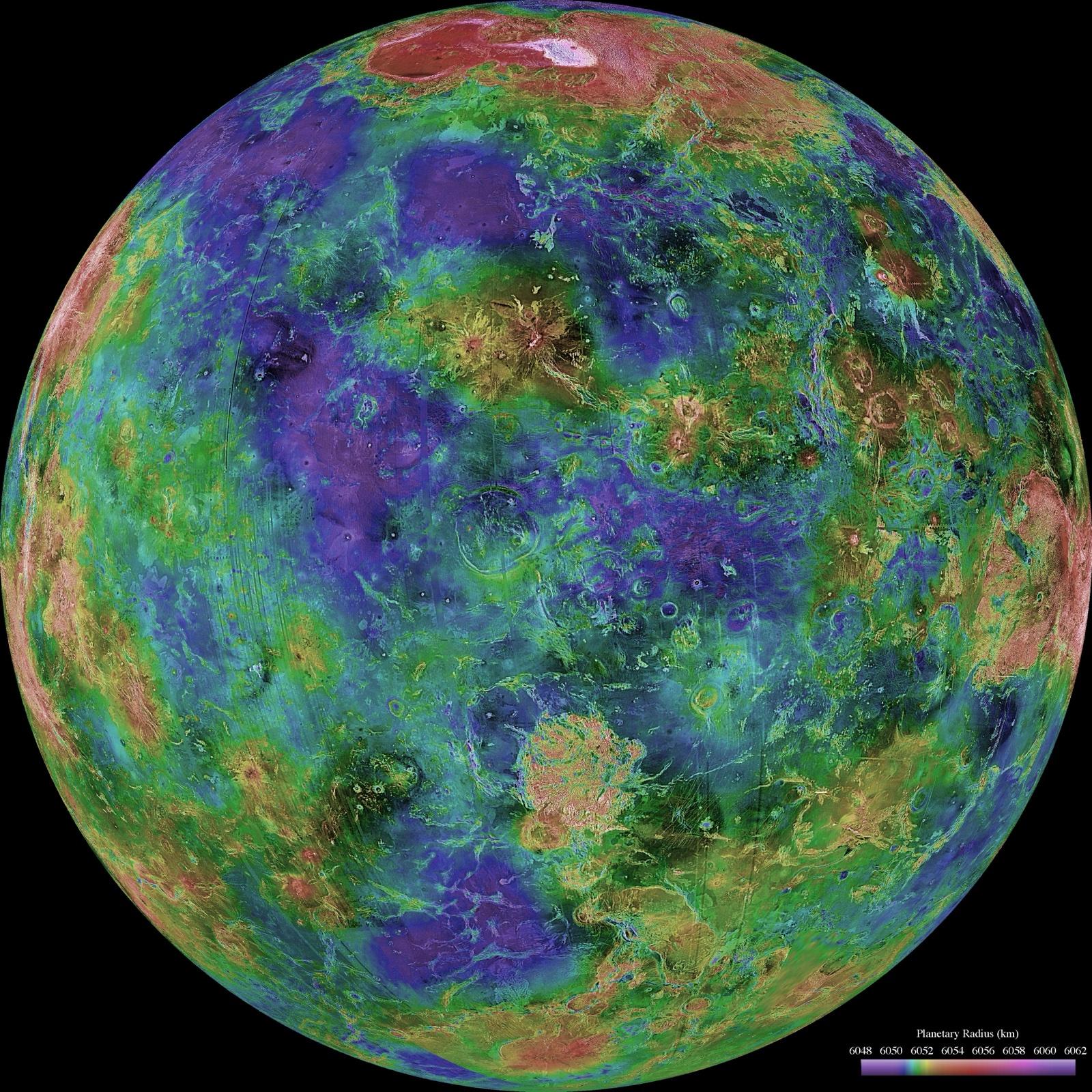
Magellan finished the job, imaging more than 98 percent of Venus at about 100 m resolution in radar passes between 1990 and 1992. The familiar globe is a composite, and NASA's caption for the hemisphere centred on 0 degrees says how: Magellan mosaics as the base, gaps filled with Arecibo images near 0 degrees latitude and longitude and with a neutral tone near the south pole, missing heights filled from Venera and Pioneer Venus altimetry, and colour for elevation. Names followed the images. The gazetteer dates 491 approvals to 1994 and 760 to 1997, then a trickle; the latest ten were approved on 5 May 2023.
The rules sit in the IAU's table of themes. Craters over 20 km honour women who made outstanding or fundamental contributions to their field, and smaller ones take common female first names; coronae are fertility and earth goddesses, chasmata goddesses of hunt and the Moon, terrae goddesses of love, tesserae goddesses of fate and fortune, planitiae mythological heroines, farra (pancake-like structures) water goddesses. Two rows carry caveats: montes are 'goddesses, miscellaneous (also one physicist)', who is Maxwell, and regiones 'giantesses and Titanesses (also two Greek alphanumeric)', Alpha and Beta. The IAU's general rules add that names must avoid political, military or religious significance (political figures before the 19th century excepted), that nobody is commemorated until dead for at least three years, and that selection should be equitable across ethnic groups, countries and gender. Mead, 270 km across and named for the anthropologist Margaret Mead, is the gazetteer's widest crater.
The long valleys are the planet naming itself: channels 400 km or longer carry the word for Venus in a world language, and shorter ones river goddesses. In the current file 38 of the 72 valles are named this way, from Baltis Vallis, the Syrian word and at 6,000 km the longest valley in the gazetteer, through Citlalpul (Aztec), Utrenitsa (Old Russian), Kinsei (Japanese) and Ikhwezi (Zulu). The edges are loose: Kinsei Vallis is listed at 375 km, below the threshold, while Saga and Sinann Valles, above it, carry river goddess names.
Zero longitude has moved with the maps. Goldstein put his zero on Alpha, and in 1988 Rzhiga still wrote that meridians on Venus are counted from Alpha. Today the gazetteer fixes zero at the central peak of Ariadne, a 23.6 km crater at 43.9 degrees north; the feature once called Eve (crater) is now Eve Corona, 330 km across. The rotation model in NASA's NAIF planetary constants kernel matches a sidereal period of 243.0185 days, fitted to Magellan images by Merton Davies and colleagues in 1992 (Rzhiga had quoted an IAU-adopted 243.01 days). In 2012 ESA reported that Venus Express had found surface features up to 20 km from where that period put them, as if the day averaged 6.5 minutes longer, and a 2021 study led by Jean-Luc Margot, with Campbell among its authors, used Earth-based radar speckle observations to measure an average of 243.0226 days for 2006 to 2020, with the length of day varying by about 20 minutes.
The summit has had several addresses. Rzhiga gives the highest point from the January 1984 Venera survey as 11.5 km above a 6,051 km sphere at 65.9 degrees north, 2.3 degrees east, and Pioneer Venus's as 11.1 km some 220 km farther south; NASA's Magellan caption puts Maxwell almost 11 km above the mean radius, and the top value in Magellan's 1997 topography is 11,687 m above 6,051.0 km. The reference spheres and sampling differ, so the figures need not agree. From 1994 the gazetteer also carried Skadi Mons at 64.0 degrees north, 4.0 degrees east inside Maxwell Montes, and Guinness World Records listed it as the tallest mountain on Venus. On 17 December 2025 the name was dropped 'because topographic data analysis has shown there is no mons feature at this location'. Guinness, checked on 4 November 2026, credits an unnamed cluster of peaks in Maxwell, provisionally called the Western Pinnacles by the researcher Jim Singh, at 10,690 m above the mean radius, and notes that a strip of missing Magellan data crosses it; that name has no IAU standing.
Ishtar Terra in the north, named for the Babylonian goddess of love, holds Lakshmi Planum, a plateau 2.5 to 5 km high (Rzhiga) named for the Indian goddess of love and war and ringed by Maxwell, Akna and Freyja Montes and the scarp of Vesta Rupes. Most of Maxwell returns radar strongly; NASA's Magellan caption suggests a reflective mineral such as pyrite, stable only within a band of altitude. Along the equator, Aphrodite Terra runs 10,000 km, with Ovda Regio, named for a Marijian Titaness, in its western part, and Diana Chasma, one of the steep-sided troughs the IAU calls chasmata, to the east. Artemis Corona, 2,600 km across and the widest corona in the gazetteer, takes its name from Artemis Chasma. In the far south Lada Terra, named in 1982 for the Slavic goddess of love, holds Quetzalpetlatl Corona, named for an Aztec fertility goddess. Addams, 87 km across at 56.2 degrees south, honours the social reformer Jane Addams.
Alpha Regio is the planned descent target of DAVINCI (NASA mission page, updated 14 July 2026). Beta Regio holds the landing areas of Venera 9 and 10 in its north-eastern and south-eastern parts, according to geological mapping by A. M. Abdrakhimov of the Vernadsky Institute, who places Venera 13 and 14 on Navka Planitia east of Phoebe Regio and Vega 1 and 2 in Rusalka Planitia, named for a Russian mermaid.
In Atla Regio, Robert Herrick and Scott Hensley reported in Science in 2023 a vent of about 2.2 square kilometres associated with Maat Mons that changed shape between February and October 1991. The rift across Atla is officially Ganis Chasma, for a western Lapp forest maiden; ESA's 2015 material on Venus Express hot spots calls it Ganiki Chasma, a name absent from the gazetteer, where Ganiki is a plain. In Eistla Regio stands Sif Mons. In 2024 Davide Sulcanese, Giuseppe Mitri and Marco Mastrogiuseppe read radar changes on Sif's western flank and in western Niobe Planitia as new lava flows; on 22 April 2026 Nature Astronomy published a comment by Bhiravarasu and colleagues arguing that differing viewing geometry explains the changes, with a reply in which the original authors hold that geometry alone cannot, so the question is open. Farther south, Idunn Mons in Imdr Regio was mapped in 2017 by Piero D'Incecco and colleagues as a site of 'recently active lava flows', and Themis Regio was studied in 2016 by Ellen Stofan and colleagues for recent volcanism in Venus Express VIRTIS data. The newest find is underground: on 9 February 2026 Leonardo Carrer, Elena Diana and Lorenzo Bruzzone of the University of Trento reported in Nature Communications a conduit beside a skylight in the Nyx Mons region, which they hypothesise is a lava tube about 1 km across; they traced it at least 300 m from the skylight and infer from aligned pits that it runs 45 km or more. The volcanoes on Venus page has the detail.
The next remapping has not flown. India's Venus Orbiter Mission is to carry a mapping radar, and the Trento release notes that VERITAS and EnVision are both to carry imaging radars; none had launched by 4 November 2026, and their pages give their status. Until one of them arrives, the 1,985 names sit on a map built almost entirely from data gathered before 1995, and each new study of old Magellan data, from Skadi Mons to Nyx Mons, still edits it.
What we know
Radar race: the false value
Lincoln Laboratory's 1958 detection, which Jodrell Bank said in 1959 it had validated, gave an astronomical unit of 149,467,000 km that proved false; Lincoln could not repeat its own detection.
Radar race: JPL's value
Goldstone first pointed at Venus on 10 March 1961; after ranging runs from 18 April to 5 May, Victor and Stevens announced 149,599,000 km, give or take 1,500 km, in Science in July 1961. Butrica calls it the first unambiguous detection; Lincoln later found an echo of 6 March 1961 on its own tapes.
Soviet 1961 radar: two values
Observations 18 to 26 April 1961. Pravda and Izvestia printed a first value on 12 May 1961, which Butrica tabulates as 149,457,000 km; IRE's full analysis gave 149,598,000 km (r.m.s. error 3,300 km) from the Doppler shift and 149,599,300 km (maximum error 2,000 km) overall, and said the newspaper value was wrong.
Soviet 1961 radar: rotation (two readings)
About 11 days (9 with a tilted axis) if the broad echo came from the whole surface, or more than 100 days if Venus scattered like the Moon. After the 1962 observations the group settled on a retrograde period of 200 to 300 days (Butrica).
Retrograde spin
Roland Carpenter's JPL report of 1 May 1962 suggested a retrograde period of about 150 days; Goldstone's near-daily observations of 1 October to 17 December 1962 at 12.6 cm (13 kW) followed a persistent surface feature, and Carpenter and Goldstein stated the retrograde spin in Science on 8 March 1963. Lincoln's William B. Smith saw it in 1961 data, but his February 1963 abstract said only 'very slow or possibly retrograde' (Butrica).
MIR, LENIN, SSSR (Yevpatoria)
Morse code sent at Venus on 19 November (MIR) and 24 November 1962 (LENIN, SSSR) at 769 MHz (39 cm), 50 kW, 10 s dots and 30 s dashes, through the ADU-1000 array of eight 16 m dishes (IRE). Butrica describes the 1961 Soviet radar as a 700 MHz (43 cm) pulse system.
First named features
Alpha and Beta from Goldstein's 1964 spectra at JPL; Maxwell from Jurgens's Arecibo images of 4 September 1967, named at Tommy Gold's urging with Gauss, Hertz and Faraday.
Naming themes set in 1975
At its Moscow meeting of 14 to 18 July 1975 the IAU working group chose the 'feminine mystique long associated with Venus' and the names of deceased radio, radar and space scientists, with Alpha admitted as an exception; Beta and Maxwell were approved by 1979.
Pioneer Venus altimeter
17 cm radar altimeter; one height every 12 s, about 120 km along track, tracks 150 to 160 km apart at the equator; the 1980 topographic map covers 65 degrees south to 75 degrees north (Rzhiga).
Venera 15 and 16 survey
First radar survey 16 October 1983; pole to 30 degrees north, 115 million square km, a quarter of the planet, in 1983 and 1984; 27 map sheets built entirely by computer at IRE with TsNIIGAiK, all complete by mid-1987 (Rzhiga).
1985 names (two counts)
Approved by the IAU General Assembly in Delhi in November 1985: more than 250 names according to Rzhiga; the gazetteer dates 224 names to 1985.
Magellan coverage
More than 98 percent of Venus at about 100 m resolution (published figures run from better than 100 m in NSSDCA's catalogue to better than 300 m on average in JPL's 1994 summary; the Magellan page lists them); in NASA's 1998 hemispheric view, gaps are filled with Arecibo images, a neutral tone and Venera and Pioneer Venus altimetry (NASA caption).
Gazetteer totals
1,985 approved names in the file dated 3 November 2026: 881 craters, 341 coronae, 118 montes, 99 dorsa, 73 paterae, 72 valles, 65 tesserae, 63 chasmata, 62 tholi, 54 fluctus, 41 planitiae and smaller groups. Biggest approval years: 1994 (491) and 1997 (760); the latest ten were approved on 5 May 2023.
The three exceptions
Montes: 'goddesses, miscellaneous (also one physicist)', that is Maxwell. Regiones: 'giantesses and Titanesses (also two Greek alphanumeric)', that is Alpha and Beta.
Craters
Over 20 km: women with outstanding or fundamental contributions to their field; under 20 km: common female first names. 335 craters are 20 km or wider and 546 smaller; Mead is the widest at 270 km.
Valles named for the planet
Valleys 400 km or longer take the word for Venus in world languages: 38 of 72 valles, led by Baltis Vallis (Syrian, 6,000 km). Kinsei Vallis (Japanese) is listed at 375 km.
Prime meridian
Defined by the central peak of the crater Ariadne, 23.6 km across at 43.9 degrees north, approved 1985. The feature once called Eve (crater) is now Eve Corona.
Rotation period (three readings)
243.0185 plus or minus 0.0001 days from Magellan images (Davies and others, 1992), matching the rotation rate in NASA's NAIF planetary constants kernel; about 6.5 minutes longer on average from Venus Express (ESA, 2012); 243.0226 plus or minus 0.0013 days averaged over 2006 to 2020, varying by about 20 minutes (Margot and others, 2021).
What happened, and when
- 1728Francesco Bianchini publishes a book of telescopic drawings showing markings on Venus that later proved illusory.
- 1958 to 1959Lincoln Laboratory, then Jodrell Bank, announce radar echoes from Venus and an astronomical unit of 149,467,000 km; the value is later shown to be false.
- 10 March 1961JPL's Goldstone radars are pointed at Venus and record what Butrica calls the first unambiguous echoes.
- 18 to 26 April 1961Kotelnikov's IRE team observes Venus by radar from Yevpatoria.
- 12 May 1961Pravda and Izvestia print the Soviet preliminary astronomical unit, which the team's own 1962 paper later called wrong.
- 1 October to 17 December 1962Goldstone observes Venus almost daily; Carpenter tracks a persistent surface feature and confirms the retrograde spin.
- 19 and 24 November 1962The Yevpatoria radar transmits MIR, then LENIN and SSSR, in Morse code at Venus.
- 1964Goldstein picks out Alpha and Beta in Goldstone echo spectra, the first surface features identified on Venus in Butrica's account.
- 4 September 1967Arecibo range-Doppler images in which Jurgens finds a new feature, Maxwell.
- 14 to 18 July 1975The IAU working group, meeting in Moscow, sets the themes for Venus names.
- 1979First 13 Venus names approved, including Maxwell Montes, Alpha Regio, Beta Regio, Ishtar Terra and Aphrodite Terra.
- June 1980Map of Venus from Pioneer Venus radar altimetry issued by NASA Ames, the USGS and MIT, with early feature names.
- 16 October 1983Venera 15 carries out its first radar-imaging survey of Venus, according to Rzhiga.
- November 1985The IAU General Assembly in Delhi approves the Venera 15 and 16 nomenclature.
- 1990 to 1992Magellan's synthetic-aperture radar maps the surface of Venus.
- 1 December 2020Arecibo Observatory's 305 m telescope collapses.
- 17 December 2025The IAU drops the name Skadi Mons: topographic analysis shows no mountain at its location.
- 9 February 2026Leonardo Carrer, Elena Diana and Lorenzo Bruzzone (University of Trento) report in Nature Communications a possible lava tube beside a skylight in the Nyx Mons region, found in Magellan radar data.
In pictures
Tap a photo to enlarge.
Translated from the original sources
Passages from the Russian and Italian sources this page draws on, in azmth's translation. Tap Show original to read the original wording.
O. N. Rzhiga, A New Era in the Study of Venus
Russian · 2 passages
O. N. Rzhiga, A New Era in the Study of Venus (Znanie, Moscow, 1988): role of radio methods
Open the source“In the Soviet Union these observations used the transmitting antenna of the Deep Space Communications Centre, which was intended for controlling spacecraft.”
azmth's translation · Show originalHide original
Russian: «В Советском Союзе для этих наблюдений использовалась передающая антенна Центра дальней космической связи, предназначенная для управления космическими аппаратами.»
“The International Astronomical Union has adopted a rotation period for Venus of 243.01 days, with the north pole at right ascension 272.8 degrees and declination 67.2 degrees.”
azmth's translation · Show originalHide original
Russian: «Международным астрономическим союзом период вращения Венеры принят равным 243,01 сут, координаты северного полюса: прямое восхождение 272,8°, склонение 67,2°.»
O. N. Rzhiga
Russian · 2 passages
O. N. Rzhiga (1988): radar images of Venus obtained from Earth
Open the source“The planet turns its opposite hemisphere towards Earth three months later, when the distance between it and Earth has grown threefold and the power of the reflected signals has fallen almost a hundredfold.”
azmth's translation · Show originalHide original
Russian: «Противоположным полушарием планета поворачивается к Земле спустя 3 месяца, когда расстояние между нею и Землей возрастает в 3 раза и мощность отраженных сигналов уменьшается почти в 100 раз.»
“In the southern hemisphere lies Alpha Regio, from which meridians on Venus are counted.”
azmth's translation · Show originalHide original
Russian: «В южном полушарии лежит Область Альфа, от которой ведется отсчет меридианов на Венере.»
O. N. Rzhiga
Russian · 2 passages
O. N. Rzhiga (1988): the Pioneer Venus topographic map
Open the source“At the end of 1978 the American spacecraft Pioneer Venus was put into orbit around Venus; among its other scientific instruments it carried a small radio altimeter working at a wavelength of 17 cm.”
azmth's translation · Show originalHide original
Russian: «В конце 1978 г. на орбиту спутника Венеры был выведен американский космический аппарат «Пионер-Венера», на борту которого среди другой научной аппаратуры был установлен небольшой радиовысотомер, работавший на длине волны 17 см.»
“The map covers its surface between 65 degrees south latitude and 75 degrees north latitude.”
azmth's translation · Show originalHide original
Russian: «Карта охватывает ее поверхность между 65° южной широты и 75° северной широты.»
O. N. Rzhiga
Russian · 2 passages
O. N. Rzhiga (1988): making photomaps and topographic maps of Venus
Open the source“But the volume of material gathered showed that this work could not be done in an acceptable time: drawing the maps by hand with relief shading would have taken at least 10 years.”
azmth's translation · Show originalHide original
Russian: «Однако объем снятого материала показал нереальность выполнения этой работы в приемлемые сроки: при рисовании карт вручную с отмывкой рельефа потребовалось бы не менее 10 лет.»
“For the first time every operation in making a map, including synthesising the radar images and height profiles of the Venus surface from the reflected signal, transforming them into a given map projection, removing perspective distortions, and drawing the coordinate grid, contours and lettering, was carried out entirely by digital methods.”
azmth's translation · Show originalHide original
Russian: «Впервые все операции по созданию карты, включая синтез радиолокационных изображений и профилей высот поверхности Венеры по отраженному сигналу, перестроение их в определенную картографическую проекцию, устранение перспективных искажений, нанесение координатной сетки, горизонталей и надписей целиком выполнены цифровыми методами.»
O. N. Rzhiga
Russian · 3 passages
O. N. Rzhiga (1988): the structure of Ishtar Terra
Open the source“But whether the crater [Cleopatra] formed by an eruption of magma or by the impact of a very large meteorite is unknown (specialists have not yet reached agreement).”
azmth's translation · Show originalHide original
Russian: «Однако образовался ли кратер в результате извержения магмы или удара очень крупного метеорита - неизвестно (специалисты пока не пришли к единому мнению).»
“In the northern part of the oval, 200 km west of the centre of Cleopatra crater (longitude 2.3 degrees, latitude 65.9 degrees), lies the highest point, 11.5 km.”
azmth's translation · Show originalHide original
Russian: «В северной части овала в 200 км к западу от центра кратера Клеопатры (долгота 2,3°, широта 65,9°) находится наивысшая точка 11,5 км*.»
“The high Lakshmi Planum, about 1,500 km from north to south and 2,000 km from west to east, has a height of 2.5 to 5 km.”
azmth's translation · Show originalHide original
Russian: «Высокогорное Плато Лакшми протяженностью около 1500 км с севера на юг и 2000 км с запада на восток имеет высоту от 2,5 до 5 км.»
O. N. Rzhiga
Russian · 2 passages
O. N. Rzhiga (1988): the surface as a mirror of geological history
Open the source“These zones, which have a distinctive surface pattern and are not found on other planets, received the name 'tessera' ('tile', from the Greek).”
azmth's translation · Show originalHide original
Russian: «Эти зоны, имеющие специфический рисунок поверхности и не встречающиеся на других планетах, получили наименование «Тессера» («черепица» с греческого).»
“These formations, not found on other planets, received the name 'venets' (crown).”
azmth's translation · Show originalHide original
Russian: «Эти образования, невстречающиеся на других планетах, получили наименование «Венец».»
O. N. Rzhiga
Russian · 6 passages
O. N. Rzhiga (1988): a little history
Open the source“The idea of the experiment arose at IRE of the USSR Academy of Sciences in the autumn of 1972.”
azmth's translation · Show originalHide original
Russian: «Идея эксперимента возникла в ИРЭ АН СССР осенью 1972 г.»
“By the middle of 1987 all 27 maps of the surveyed territory of Venus had been built, in four versions.”
azmth's translation · Show originalHide original
Russian: «К середине 1987 г. для снятой территории Венеры построены все 27 карт в четырех вариантах.»
“On 16 October 1983 the Venera 15 spacecraft carried out a radar survey of the planet Venus for the first time.”
azmth's translation · Show originalHide original
Russian: «16 октября 1983 г. космический аппарат «Венера-15» впервые осуществил радиолокационную съемку планеты Венера.»
“The nomenclature of surface features of Venus for the maps being published was approved by the 19th General Assembly of the International Astronomical Union, held in Delhi in November 1985.”
azmth's translation · Show originalHide original
Russian: «Номенклатура деталей поверхности Венеры для издаваемых карт утверждена XIX Генеральной ассамблеей Международного астрономического союза, состоявшейся в ноябре 1985 г. в Дели.»
“The nomenclature contains more than 250 names.”
azmth's translation · Show originalHide original
Russian: «Номенклатура содержит свыше 250 наименований.»
“Thus on the first published map, 'Lakshmi Planum', we see craters named after Yekaterina Dashkova, Anna Akhmatova, Polina Osipenko and Eugenie Cotton.”
azmth's translation · Show originalHide original
Russian: «Так, на первой изданной карте «Плато Лакшми» мы видим кратеры имени Екатерины Дашковой, Анны Ахматовой, Полины Осипенко, Эжени Коттон.»
O. N. Rzhiga
Russian · 1 passage
O. N. Rzhiga (1988): conclusion
Open the source“The area surveyed is 115 million square kilometres, a quarter of the total surface area of Venus.”
azmth's translation · Show originalHide original
Russian: «Площадь снятой территории 115 млн. км2, что составляет четвертую часть от общей площади поверхности Венеры.»
V. A. Kotelnikov and others, 'Results of radar observation of Venus in 1961', Radiotekhnika i elektronika 7
Russian · 3 passages
V. A. Kotelnikov and others, 'Results of radar observation of Venus in 1961', Radiotekhnika i elektronika 7 (11), 1962 (transcription on a private website; journal not consulted)
Open the source“Therefore the value of the astronomical unit given in the newspapers is also wrong.”
azmth's translation · Show originalHide original
Russian: «Поэтому указанное в газетах значение астрономической единицы также ошибочно.»
“The astronomical unit equals 149,599,300 km with a maximum error of plus or minus 2,000 km.”
azmth's translation · Show originalHide original
Russian: «Астрономическая единица равна 149 599 300 км с максимальной ошибкой ±2000 км.»
“On this assumption, for the lines to be smeared by plus or minus 200 Hz the rotation period of Venus must be about 11 days, if its rotation axis is perpendicular to the direction to Earth and the whole surface reflects.”
azmth's translation · Show originalHide original
Russian: «При данном предположении для размытия линий на ±200 гц период вращения Венеры должен составлять примерно 11 суток, если её ось вращения перпендикулярна направлению на Землю и отражает вся поверхность.»
Kotelnikov Institute of Radio Engineering and Electronics, RAS: 65 years
Russian · 1 passage
Kotelnikov Institute of Radio Engineering and Electronics, RAS: 65 years (institutional history, 2018)
Open the source“Analysis of these unique data produced, and later published, the first 'Atlas of the Surface of Venus' in the history of science (Moscow, MIIGAiK, 1989).”
azmth's translation · Show originalHide original
Russian: «В результате анализа этих уникальных данных был создан и впоследствии опубликован первый в истории науки "Атлас поверхности Венеры" (М., МИИГАиК, 1989)»
Universita di Trento: Anche Venere ha i suoi tunnel
Italian · 4 passages
Universita di Trento: Anche Venere ha i suoi tunnel (9 February 2026)
Open the source“Between 1990 and 1992 a synthetic aperture radar, an instrument aboard NASA's Magellan spacecraft, mapped the surface of Venus.”
azmth's translation · Show originalHide original
Italian: “Tra il 1990 e il 1992, un radar ad apertura sintetica (Synthetic Aperture Radar), strumento a bordo della sonda spaziale Magellan della Nasa, ha mappato la superficie venusiana.”
“Both spacecraft [EnVision and VERITAS] will carry radar imaging systems able to improve the identification and study of skylights.”
azmth's translation · Show originalHide original
Italian: “Entrambe le navicelle saranno dotate di sistemi di imaging radar in grado di migliorare l’identificazione e lo studio dei lucernari.”
“Our analyses revealed the existence of a large underground conduit in the Nyx Mons region, the geological feature named after the Greek goddess of Night.”
azmth's translation · Show originalHide original
Italian: “Le nostre analisi hanno rivelato l'esistenza di un grande condotto sotterraneo nella regione di Nyx Mons, il rilievo geologico che prende il nome dalla dea greca della Notte.”
“We interpret the structure as a possible lava tube, with an estimated diameter of about one kilometre, a roof at least 150 metres thick, extending underground to a depth of at least 375 metres.”
azmth's translation · Show originalHide original
Italian: “Interpretiamo la struttura come un possibile tubo di lava (pirodotto), con un diametro stimato di circa un chilometro, uno spessore del tetto di almeno 150 metri e che si estende nel sottosuolo per una profondità di almeno 375 metri”
Sources
- A. J. Butrica, To See the Unseen: A History of Planetary Radar Astronomy, NASA SP-4218 (1996)
- IAU/USGS Gazetteer of Planetary Nomenclature, Venus centre points (bulk file dated 3 November 2026)
- IAU/USGS Gazetteer: categories (themes) for naming features
- IAU/USGS Gazetteer: IAU rules and conventions
- IAU/USGS Gazetteer: descriptor terms
- IAU/USGS Gazetteer: history of planetary nomenclature
- IAU/USGS Gazetteer: Skadi Mons (dropped 17 December 2025)
- IAU/USGS Gazetteer: Maxwell Montes
- IAU/USGS Gazetteer: Ariadne
- IAU/USGS Gazetteer: Eve Corona
- IAU/USGS Gazetteer: Ganis Chasma
- O. N. Rzhiga, A New Era in the Study of Venus (Znanie, Moscow, 1988): role of radio methods · in Russian
- O. N. Rzhiga (1988): radar images of Venus obtained from Earth · in Russian
- O. N. Rzhiga (1988): the Pioneer Venus topographic map · in Russian
- O. N. Rzhiga (1988): making photomaps and topographic maps of Venus · in Russian
- O. N. Rzhiga (1988): the structure of Ishtar Terra · in Russian
- O. N. Rzhiga (1988): the surface as a mirror of geological history · in Russian
- O. N. Rzhiga (1988): a little history · in Russian
- O. N. Rzhiga (1988): conclusion · in Russian
- V. A. Kotelnikov and others, 'Results of radar observation of Venus in 1961', Radiotekhnika i elektronika 7 (11), 1962 (transcription on a private website; journal not consulted) · in Russian
- IRE RAS: 'MIR, LENIN, SSSR'
- Kotelnikov Institute of Radio Engineering and Electronics, RAS: 65 years (institutional history, 2018) · in Russian
- MIT News: Gordon Pettengill obituary (1 June 2021)
- Linda Hall Library: Scientist of the Day, Francesco Bianchini
- NASA Photojournal PIA00157: hemispheric view of Venus centred at 0 degrees east
- NASA Photojournal PIA00149: Maxwell Montes and Cleopatra crater
- NASA Photojournal PIA00104: computer-simulated global view centred at 180 degrees east
- NASA Image Library ARC-1990-A90-3002: Magellan and Arecibo comparison
- NASA Image Library ARC-1980-AC78-9135: Pioneer Venus map, June 1980
- NASA Image Library PIA00461: Bahet and Onatah Coronae
- NASA Image Library PIA00148: Mead crater
- NASA Image Library PIA00101: Artemis Chasma
- USGS Astrogeology: Venus Magellan Global Topography 4641 m (GTDR version 2, 1997)
- M. E. Davies and others, 'The rotation period, direction of the north pole, and geodetic control network of Venus', JGR 97 (1992), abstract via Crossref
- NAIF generic planetary constants kernel pck00011
- ESA: Could Venus be shifting gear? (10 February 2012)
- J.-L. Margot and others, 'Spin state and moment of inertia of Venus', Nature Astronomy (29 April 2021)
- US National Science Foundation: Arecibo media toolkit (updated 15 January 2026)
- Guinness World Records: Tallest mountain on Venus
- JPL: NASA's Magellan data reveals volcanic activity on Venus (15 March 2023)
- D. Sulcanese, G. Mitri and M. Mastrogiuseppe, Nature Astronomy (27 May 2024)
- Bhiravarasu and others, 'Challenges to detecting present-day volcanism on Venus', Nature Astronomy (22 April 2026)
- P. D'Incecco and others, 'Idunn Mons on Venus: location and extent of recently active lava flows', Planetary and Space Science (2017)
- E. R. Stofan and others, 'Themis Regio, Venus: evidence for recent (?) volcanism from VIRTIS data', Icarus (2016)
- ESA: Brightness changes in Ganiki Chasma (18 June 2015)
- Universita di Trento: Anche Venere ha i suoi tunnel (9 February 2026) · in Italian
- A. M. Abdrakhimov, Geologic mapping of Venera 9 landing site region, LPSC XXXII (2001)
- A. M. Abdrakhimov, Geologic mapping of Venera 13 landing site region, LPSC XXXII (2001)
- A. M. Abdrakhimov, Geologic mapping of Vega 1 landing site region, LPSC XXXII (2001)
- A. M. Abdrakhimov, Geologic mapping of Venera 10 landing site region, LPSC XXXII (2001)
- A. M. Abdrakhimov, Geologic mapping of Venera 14 landing site region, LPSC XXXII (2001)
- A. M. Abdrakhimov, Geologic mapping of Vega 2 landing site region, LPSC XXXII (2001)
- R. R. Herrick and S. Hensley, 'Surface changes observed on a Venusian volcano during the Magellan mission', Science (2023), abstract via Crossref
- L. Carrer, E. Diana and L. Bruzzone, 'Radar-based observation of a lava tube on Venus', Nature Communications 17, 1147 (9 February 2026)
- D. Sulcanese, G. Mitri and M. Mastrogiuseppe, 'Reply to: Challenges to detecting present-day volcanism on Venus', Nature Astronomy (22 April 2026)
- NASA: DAVINCI mission page (last updated 14 July 2026)
- ISRO: Venus Orbiter Mission configuration and scientific objectives (VSAR radar for global mapping; launch planned for March 2028; read 4 November 2026)
Checked on 4 November 2026. Where the science is unsettled this page says so rather than picking a winner.
azmth is independent and is not affiliated with or endorsed by NASA, Roscosmos, NPO Lavochkin, ESA, JAXA, ISRO, CNSA, or any other space agency or company named on this page.