Magellan
NASA and JPL · United States · Orbiter · 1990 · Radar, and the return Success
Ended. Contact was lost on 12 October 1994 during a planned last plunge into the upper atmosphere, and the orbiter is presumed to have burned up soon after. Its radar images still feed new research, including a 2026 study of a lava tube and a published debate over fresh lava flows.
TL;DR· 16 min read
Magellan was a NASA orbiter whose single instrument, a radar, mapped 98 percent of Venus through its clouds between 1990 and 1992 and then helped measure the planet's gravity. Its maps showed a surface shaped by volcanoes. It was the cheaper successor of the cancelled VOIR project and was carried into space by the Space Shuttle Atlantis in 1989. In 1993 it dipped into the atmosphere to round off its orbit, and in October 1994 controllers sent it deeper until it fell silent.
What did the Magellan spacecraft do at Venus?
Magellan was the NASA orbiter that mapped Venus by radar. From September 1990 to September 1992 it imaged 98 percent of the surface through the planet's permanent clouds, then spent two more years measuring its gravity field, 95 percent of it at high resolution. The Space Shuttle Atlantis carried it into Earth orbit on 4 May 1989, and it reached Venus on 10 August 1990. It was the cheaper successor of VOIR, a larger radar mission that NASA gave up in 1981. Its maps showed a world shaped by volcanoes, with lava flows over at least 85 percent of the surface. In 1993 it rounded off its orbit by skimming the upper atmosphere for 70 days, a technique called aerobraking, and in October 1994 controllers sent it deeper for a final experiment. Its last signal arrived on 12 October 1994.
Facts as of 26 September 2026, from the sources listed below.
- 98 percentof the surface imaged by radar at better than 300 m average resolution (JPL, October 1994)
- 95 percentof the planet covered by the high-resolution gravity map (JPL)
- 730 orbitsof aerobraking in 1993 that cut the orbit's high point from about 8,500 km to 541 km (JPL engineers)
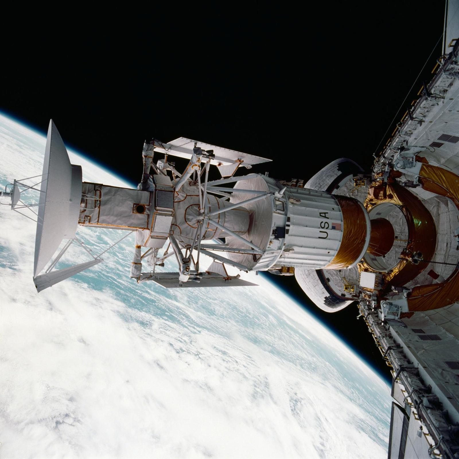
Magellan carried one instrument to Venus: a radar that used the spacecraft's 3.7 m communications dish as its antenna. Between September 1990 and September 1992 it imaged 98 percent of the surface through the permanent cloud, according to the Jet Propulsion Laboratory's closing status report, and two further years of radio tracking produced a gravity map covering 95 percent of the planet. Its archive was still yielding new studies in 2026.
The mission grew out of a bigger one. In the early 1970s NASA's Ames Research Center and JPL studied Venus radar orbiters separately, and Louis Friedman and Al Laderman named JPL's project the Venus Orbiting Imaging Radar, VOIR, after the French verb voir, to see, according to Andrew Butrica's NASA history of planetary radar, To See the Unseen (1996). By 1978 its plan drew on parts from Mariner 10, Voyager and Pioneer Venus, with a radar derived from the Seasat satellite's. R. Stephen Saunders, a JPL geologist, was principal study scientist of the VOIR group and later Magellan's project scientist.
VOIR never flew. Congress had already voted it a new start when Ronald Reagan took office in January 1981, Butrica writes, but budget director David Stockman pressed NASA to give up a major project to signal spending cuts, and NASA chose VOIR, priced at 680 million dollars. One risk JPL had listed in 1978 for a late launch, that the Soviet Union would get radar images of Venus first, then came true: Venera 15 and 16 reached the planet in October 1983 and mapped its northern quarter by radar.
Its replacement was cheaper by design. Gordon Pettengill of MIT, later the radar's principal investigator, told Butrica that staff were promised their mission if they could cut its cost in half. The Venus Radar Mapper, VRM, aimed at 200 to 300 million dollars, dropped the four experiments that did not use the radar and became a NASA new start in 1984. An elliptical orbit spared it the aerobraking VOIR's circular orbit would have needed after arrival. In December 1985 NASA Headquarters told JPL the project would be called Magellan, after the Portuguese navigator (Butrica); JPL's 1990 Explorer's Guide dates the official renaming to 1986.
Meanwhile the project's scientists studied the Soviet maps that had beaten them to the planet. Between November 1985 and August 1986 Soviet scientists handed over tapes of digital Venera images, for planning only, and received Viking data of Mars and Phobos in return, according to Butrica.
Challenger was lost on 28 January 1986 while Magellan was on schedule and under budget, Butrica writes, with launch approved for April 1988 (May 1988 in JPL's 1990 Explorer's Guide). After the Shuttle/Centaur upper stage meant to launch it was cancelled in June, NASA settled in October on the shuttle, a two-stage Inertial Upper Stage and an April 1989 slot, which forced a lighter spacecraft and new load tests; Butrica puts the cost of the delay at about 150 million dollars. As loaded into Atlantis it weighed 3,453 kg by the Explorer's Guide, 3,445 kg by Siddiqi.
One radar did three jobs on each pass, according to NSSDCA: side-looking synthetic aperture imaging through the big dish, altimetry from a smaller antenna, and measurement of the microwave heat given off by the ground. Each pass imaged a strip about 20 to 25 km wide and 17,000 km long. The images are greyscale, so any colour has been added: NASA's captions describe the familiar orange globes as simulated colour.
A first countdown stopped 31 seconds before launch on 28 April 1989 over a faulty hydrogen pump and a leaking hydrogen line. On 4 May Atlantis lifted off at 18:46:59 UT (NASA's STS-30 page; Siddiqi rounds it to 18:47:00), and the crew released Magellan at 01:01 UT on 5 May. Butrica and NASA both describe it as the first planetary spacecraft launched by a space shuttle.
The route was long. The October 1989 window first set aside for Magellan went to Galileo, which needed a gravity boost from Venus, so Magellan looped more than one and a half times around the Sun over 15 months instead, according to the Explorer's Guide. It braked into orbit on 10 August 1990 behind Venus as seen from Earth, so the burn could only be confirmed about 30 minutes later. NSSDCA gives the first orbit as 294 by 8,540 km; Siddiqi gives 297 by 8,463 km, and neither explains the difference.
Within a week the mission nearly ended. On 16 August 1990, during a radar test, the spacecraft lost its internal heartbeat signal, protected itself and dropped out of contact for about 15 hours; a second silence of 17 hours followed on 21 August, after which controllers uploaded software to reset the craft in such events (Siddiqi; Butrica).
Mapping began on 15 September and ran in cycles of 243 days, the time Venus takes to turn once beneath an orbit that stays fixed in space. Cycle 1 covered 83.7 percent of the planet according to NSSDCA's cycle page and Siddiqi (84 percent in NSSDCA's catalogue record and on the PDS Magellan page), ending on 15 May 1991 (14 May on the cycle page). Cycles 2 and 3, looking west and then adding stereo views, completed the 98 percent by September 1992. Siddiqi puts the data return at 1,200 gigabits, against 900 gigabits from all NASA planetary missions combined at the time.
What the radar revealed was a volcanic world. NSSDCA's summary counts at least 85 percent of the surface as volcanic flows and the rest as highly deformed mountain belts, with no evidence of Earth-like plate tectonics. Gerald Schaber of the US Geological Survey compiled the project's inventory of 921 impact craters as of 30 July 1993: scattered at random, mostly pristine, and only 4 percent embayed by lava. His group read that as a planet-wide resurfacing about 300 million years ago followed by a steep decline in activity, while Roger Phillips and colleagues proposed a steady equilibrium resurfacing (Magellan Final Science Reports, 1993). NSSDCA gives a mean surface age of about 500 million years, and its mission page, last updated in 2005, lists sudden against gradual resurfacing as a major unanswered question. Later work on the same images has been read as evidence of eruptions during the mission itself, a reading that is disputed (see below); Volcanoes on Venus and the surface of Venus take it further.
With imaging complete, Cycle 4 (14 September 1992 to 23 May 1993) turned the dish toward Earth, and Doppler shifts in its radio signal traced the mass beneath mountains and basins (NSSDCA). From an elliptical orbit, though, the field blurred toward the poles, since resolution degrades quickly with altitude.
Aerobraking was the answer. The propellant aboard was at least an order of magnitude too small to round off the orbit with thrusters, Douglas Griffith, Saunders and Daniel Lyons wrote, so from late May 1993 the team dipped the low point into the upper atmosphere and let drag do the work on a spacecraft never designed for atmospheric flight. Over 70 days and 730 orbits the high point shrank from 8,467 km to 541 km. JPL called it a first-of-a-kind manoeuvre in 1994, and David Doody describes Magellan as the first spacecraft to use aerobraking to change the shape of its orbit significantly at another planet.
That qualifier matters. Japan's Hiten had already skimmed Earth's upper atmosphere on 19 March 1991, and Siddiqi's chronicle lists it as the first spacecraft to use aerobraking to reduce velocity; the Institute of Space and Astronautical Science describes the experiment as a success.
From the new orbit, Cycle 5 (3 August 1993 to 29 August 1994) mapped gravity at high resolution over about 95 percent of the planet. NSSDCA sums up the outcome: gravity on Venus follows its topography closely, a sign that the planet holds up its highlands differently from Earth, possibly through processes deep in the interior.
By August 1994 thermal stress had degraded the solar panels' cell connections, JPL said, and the project chose to spend the last weeks on experiments. In the windmill experiment, under way by 7 September, the panels were turned in opposite directions like windmill sails, and the torque needed to stop the spacecraft spinning gave a measure of the drag of the upper atmosphere. Betsy Beyer, the program manager at NASA Headquarters, called it "a race to the finish", since the power might fail before the planned final experiment.
The termination experiment began on 11 October 1994. JPL's status report of 12 October counts four thruster sequences, the project's weekly report the next day five orbit trim manoeuvres; together they took the low point to 139.7 km, a little above the 136 km planned in September. With power running low the team set up a last windmill run and expected two more orbits. Magellan managed three, and at 10:02 UT on 12 October, on orbit 15032, its signal was lost just as it was about to pass behind Venus as seen from Earth.
No one saw the end. The project's weekly report expected Magellan to land on Venus by 20:00 UT on 13 October, JPL's press texts said it would burn up, NSSDCA's cycle page allows that some parts may have reached the surface, and NSSDCA's catalogue says it presumably burned up on 13 or 14 October. Jonathan McDowell's catalogue of landings and impacts puts its fall at 18:00 UT on 12 October. NASA's current mission page and Siddiqi put the loss of contact a day later than JPL's reports of the time, after 10:05 UT on 13 October, with burn-up about ten hours later. None of these sources gives an entry or impact point. JPL's mission page calls it the first time an operating planetary spacecraft had been intentionally crashed; what we left at Venus gathers the other hardware.
The final bill, by NSSDCA's count, came to roughly 680 million dollars: 551 million to 29 October 1991 plus about 130 million to the end. That matches the headline price Butrica gives for VOIR in 1981, although the two figures come from different years and neither source states a price year.
Thirty years on, researchers are still mining the data, now online through the Planetary Data System. In March 2023 Robert Herrick of the University of Alaska Fairbanks and Scott Hensley of JPL reported in Science that a vent on Maat Mons, under 2.2 square km in February 1991, had doubled in size and appeared filled to the rim with lava eight months later. In May 2024, in Nature Astronomy, Davide Sulcanese, Giuseppe Mitri and Marco Mastrogiuseppe read radar brightness changes between cycles on the flank of Sif Mons and in western Niobe Planitia as new lava flows; Mitri told the Italian agency ANSA that the team now had certainty of activity. In April 2026 the same journal published a challenge by S. S. Bhiravarasu and colleagues, who argue the changes fit different viewing geometries, alongside a reply maintaining that geometry alone cannot produce the patterns. Neither side conceded in that April 2026 exchange, so the question stays open.
Magellan's gravity data have a second life too. In May 2025 Gael Cascioli of NASA's Goddard Space Flight Center and colleagues compared models of coronae with Magellan gravity and topography in Science Advances and, as INAF's news service reported, found signs of recent and perhaps continuing upwelling beneath 52 of 75 coronae. In February 2026 Leonardo Carrer, Elena Diana and Lorenzo Bruzzone of the University of Trento reported in Nature Communications an open conduit in the Nyx Mons region, which they interpret as a lava tube about 1 km across with a void at least 375 m high (a depth of at least 375 m in the university's Italian release). Radar confirms the conduit for at least 300 m; aligned openings suggest it may run for 45 km or more, a hypothesis that, Bruzzone said in the university's release, needs sharper radar data from missions such as ESA's EnVision and NASA's VERITAS.
Mission facts
Organisations
NASA and the Jet Propulsion Laboratory; spacecraft by Martin Marietta (Denver), radar by Hughes Aircraft
Magellan: names and numbers
Flown as Magellan; earlier the Venus Radar Mapper (VRM). COSPAR 1989-033B, catalogue number 19969 (NSSDCA).
Magellan: who built it
Managed by JPL for NASA; spacecraft built by Martin Marietta in Denver and radar by Hughes Aircraft in Los Angeles (JPL, 12 October 1994). Hughes signed the definitive radar contract on 24 January 1984 (Butrica).
Magellan: mass (three readings)
3,453 kg as loaded in Atlantis, including the Star 48B braking motor (2,146 kg, of which 2,014 kg propellant) and 132.5 kg of hydrazine (JPL Explorer's Guide, 1990). Siddiqi gives 3,445 kg. NSSDCA's catalogue gives 1,035 kg without saying what it includes.
Magellan: size
About 6.4 m long and 9.2 m across with its two 2.5 m square solar panels deployed (NSSDCA); JPL's 1990 Explorer's Guide gives 10 m from tip to tip of the panels; a 3.7 m dish at the front served both for communications and as the radar antenna.
Magellan: the radar
One instrument for imaging, altimetry and radiometry, at 12.6 cm wavelength (2.385 GHz), using the big dish for imaging and a smaller fan-beam antenna for altimetry. Principal investigator Gordon Pettengill (MIT).
Magellan: launch
4 May 1989 at 18:46:59 UT (NASA STS-30 page; 18:47:00 in Siddiqi) on Atlantis, STS-30, from Launch Complex 39B. Deployed 6 h 14 min into the flight (NASA), at 01:01 UT on 5 May; a two-stage Inertial Upper Stage fired about an hour later (Siddiqi).
Magellan: first orbit (two readings)
294 by 8,540 km, period 3 h 15 min, low point near 9.5 N (NSSDCA); 297 by 8,463 km at 85.5 degrees inclination (Siddiqi).
Magellan: radar coverage (two readings)
98 percent after three cycles (JPL, NSSDCA cycle table, Siddiqi, PDS). NSSDCA's catalogue record says over 99 percent and its radar experiment page approximately 99 percent, and NASA's mission page says the entire surface.
Magellan: resolution (several readings)
Better than 300 m on average (JPL, 1994); better than 100 m (NSSDCA mission page); about 150 m in radar mode (NSSDCA radar page); 100 to 150 m (NASA caption PIA18175); about 100 m (PDS). The design goal was 120 to 300 m (Siddiqi); image pixels are 75 m.
Magellan: data returned
1,200 gigabits, against 900 gigabits from all NASA planetary missions combined at the time (Siddiqi). NSSDCA counts 4,225 usable imaging orbits.
Magellan: cost
551 million dollars to 29 October 1991 (287 million spacecraft, 120 million radar, 49 million launch and first 30 days, 95 million operations and analysis) plus about 130 million to the end: roughly 680 million (NSSDCA).
VOIR: plan and price
JPL's Venus Orbiting Imaging Radar, named for the French verb voir (to see). The 1978 plan: shuttle launch May to June 1983, five months in orbit. Price 680 million dollars; NASA gave it up early in 1981 under budget pressure (Butrica).
Venus Radar Mapper: the descope
Every non-radar experiment dropped, target cost 200 to 300 million dollars, elliptical orbit and digital radar processing; a NASA new start in fiscal 1984; NASA told JPL of the new name Magellan in December 1985 (Butrica), while JPL's 1990 Explorer's Guide says it was officially renamed in 1986.
Aerobraking: numbers
70 days ending 3 August 1993, apoapsis cut from 8,467 km to 541 km (Griffith, Saunders and Lyons); 730 consecutive orbits, at most 2 m/s per pass, 1,200 m/s in all (Lyons and colleagues). Final orbit 180 by 540 km, 94 min (NSSDCA) or 197 by 541 km (Griffith and colleagues).
Aerobraking: why
The propellant aboard was at least an order of magnitude too small to circularise the orbit with thrusters, and gravity mapping near the poles needed a low, round orbit (Griffith, Saunders and Lyons).
Windmill experiment
Under way by 7 September 1994 and scheduled to 14 September: the solar panels were turned in opposite directions and the torque needed to stop the spacecraft spinning measured the drag of the upper atmosphere (JPL). NSSDCA's mission page dates it from 30 August.
Termination experiment
11 October 1994: four thruster sequences (JPL status report) or five orbit trim manoeuvres (project report) lowered the low point to 139.7 km, against the 136 km JPL had planned on 7 September; panels reached 126 °C and bus voltage fell to 20.4 V.
End of contact (two readings)
10:02 UT on 12 October 1994, orbit 15032 (JPL status report, NSSDCA; McDowell's catalogue gives the same time, and 18:00 UT that day for the fall). NASA's mission page and Siddiqi give after 10:05 UT on 13 October, with burn-up about 10 hours later.
Mission timeline
- 1978VOIR's plan calls for a shuttle launch in May or June 1983, arrival that November and five months in orbit; in October NASA asks for experiment proposals.
- Early 1981Under pressure from budget director David Stockman to give up a major project, NASA chooses VOIR.
- 1984The descoped Venus Radar Mapper becomes a NASA new start; Hughes signs the definitive radar contract on 24 January (contracts with Hughes and Martin Marietta date from 1983).
- Dec 1985NASA Headquarters tells JPL the Venus Radar Mapper will be called Magellan (Butrica); JPL's 1990 Explorer's Guide dates the official renaming to 1986.
- Jan to Oct 1986Challenger is lost on 28 January; the Shuttle/Centaur stage is cancelled in June; in October NASA moves Magellan to a shuttle with an Inertial Upper Stage in April 1989.
- 4 May 1989Atlantis lifts off at 18:46:59 UT with Magellan, six days after a countdown stopped at T minus 31 seconds.
- 5 May 1989Released from the payload bay at 01:01 UT; the Inertial Upper Stage fires about an hour later toward Venus.
- 10 Aug 1990The Star 48B motor puts Magellan into a near-polar orbit around Venus.
- 16 to 21 Aug 1990Two losses of contact, of 15 and 17 hours; controllers upload new software to reset the craft in such events.
- 15 Sep 1990Radar mapping begins (Cycle 1, looking east of the track).
- 15 May 1991Cycle 1 ends with 83.7 percent of the planet imaged (NASA; 84 percent in NSSDCA's catalogue record, and 14 May on NSSDCA's cycle page).
- Sep 1992Cycle 3, for stereo, ends with cumulative coverage at 98 percent.
- 24 May to 3 Aug 1993Aerobraking: 70 days of passes through the upper atmosphere round the orbit off to about 180 by 540 km (end date 2 or 3 August depending on source).
- 29 Aug 1994Gravity mapping from the low orbit ends with about 95 percent of the planet covered.
- 30 Aug to 14 Sep 1994The windmill experiment: solar panels turned like windmill sails to measure atmospheric drag. NSSDCA's mission page dates its start to 30 August; JPL announced it under way on 7 September and scheduled it to 14 September.
- 11 Oct 1994Thruster firings lower the orbit's low point to 139.7 km for the termination experiment.
- 12 Oct 1994Signal lost at 10:02 UT on orbit 15032 as the spacecraft, short of power, is about to pass behind Venus.
- 13 to 14 Oct 1994Magellan is presumed to have burned up in the atmosphere, unobserved.
A filled dot marks something that physically happened. A hollow one marks an announcement, a naming or a target.
In pictures
Tap a photo to enlarge.
Sources
- JPL status report, 12 October 1994, and Magellan project weekly report, 13 October 1994 (NSSDCA mirror)
- JPL news release on the windmill experiment, 7 September 1994 (NSSDCA mirror)
- NSSDCA Master Catalog: Magellan (archived copy of 15 August 2025; live record returned an error on 26 September 2026)
- NSSDCA: Magellan mission plan (cycles)
- NSSDCA: Magellan mission to Venus
- NSSDCA: Magellan Synthetic Aperture Radar experiment
- Asif Siddiqi, Beyond Earth: A Chronicle of Deep Space Exploration, 1958 to 2016 (NASA, 2018), entries 173 and 175
- Andrew Butrica, To See the Unseen: A History of Planetary Radar Astronomy, NASA SP-4218 (1996), chapter 7
- C. Young (ed.), The Magellan Venus Explorer's Guide, JPL Publication 90-24 (1990), chapters 2, 3, 4, 9 and 10 (archived copy; chapter 4 linked)
- NASA Science: Magellan
- JPL: Magellan mission page
- NASA: STS-30 mission page
- Griffith, Saunders and Lyons, The Magellan Venus Mapping Mission: Aerobraking Operations (NTRS)
- Lyons, Buescher, Esterl and Neuman, Measuring the Thermal Accommodation Coefficient while Aerobraking Magellan (NTRS)
- Doody, Aerobraking the Magellan Spacecraft in Venus Orbit (NTRS)
- Cestero and Tolson, Magellan Aerodynamic Characteristics During the Termination Experiment (NTRS)
- Lyons, Aerobraking at Venus and Mars: A Comparison of the Magellan and Mars Global Surveyor Aerobraking Phases (NTRS)
- Magellan Final Science Reports, JPL D-11092 (1993, NTRS)
- Saunders and others, Magellan mission summary, JGR Planets 97 (1992)
- Konopliv, Banerdt and Sjogren, Venus Gravity: 180th Degree and Order Model, Icarus (1999)
- PDS Geosciences Node: the Magellan mission to Venus
- NAIF: Magellan navigation SPK files, readme
- The Planetary Society: Steve Saunders
- Herrick and Hensley, Surface changes observed on a Venusian volcano during the Magellan mission, Science (2023)
- JPL news, NASA's Magellan Data Reveals Volcanic Activity on Venus (15 March 2023)
- Sulcanese, Mitri and Mastrogiuseppe, Evidence of ongoing volcanic activity on Venus revealed by Magellan radar, Nature Astronomy (2024)
- Bhiravarasu and others, Challenges to detecting present-day volcanism on Venus, Nature Astronomy (22 April 2026)
- Sulcanese, Mitri and Mastrogiuseppe, Reply to: Challenges to detecting present-day volcanism on Venus, Nature Astronomy (22 April 2026)
- Cascioli, Gülcher, Mazarico and Smrekar, A spectrum of tectonic processes at coronae on Venus revealed by gravity and topography, Science Advances (2025)
- Carrer, Diana and Bruzzone, Radar-based observation of a lava tube on Venus, Nature Communications (9 February 2026)
- University of Trento, Evidence of a subsurface lava tube on Venus (EurekAlert)
- Università di Trento, Anche Venere ha i suoi tunnel (press release) · in Italian
- INAF Media, lava flows on Venus in Magellan data (28 May 2024) · in Italian
- INAF Media, tectonic activity under Venus coronae (16 May 2025) · in Italian
- ISAS/JAXA: Hiten · in Japanese
- NSSDCA: Venus fact sheet
- NASA Photojournal, PIA18175: Magellan orbit, artist's concept (caption)
- The Magellan Venus Explorer's Guide, chapter 2 (archived copy)
- J. McDowell, GCAT lander and impact catalogue (landercat), updated 24 September 2026
Facts on this page were verified on 26 September 2026. Where sources disagree, the disagreement is stated rather than resolved silently.
azmth is independent and is not affiliated with or endorsed by NASA, Roscosmos, NPO Lavochkin, ESA, JAXA, ISRO, CNSA, or any other space agency or company named on this page.